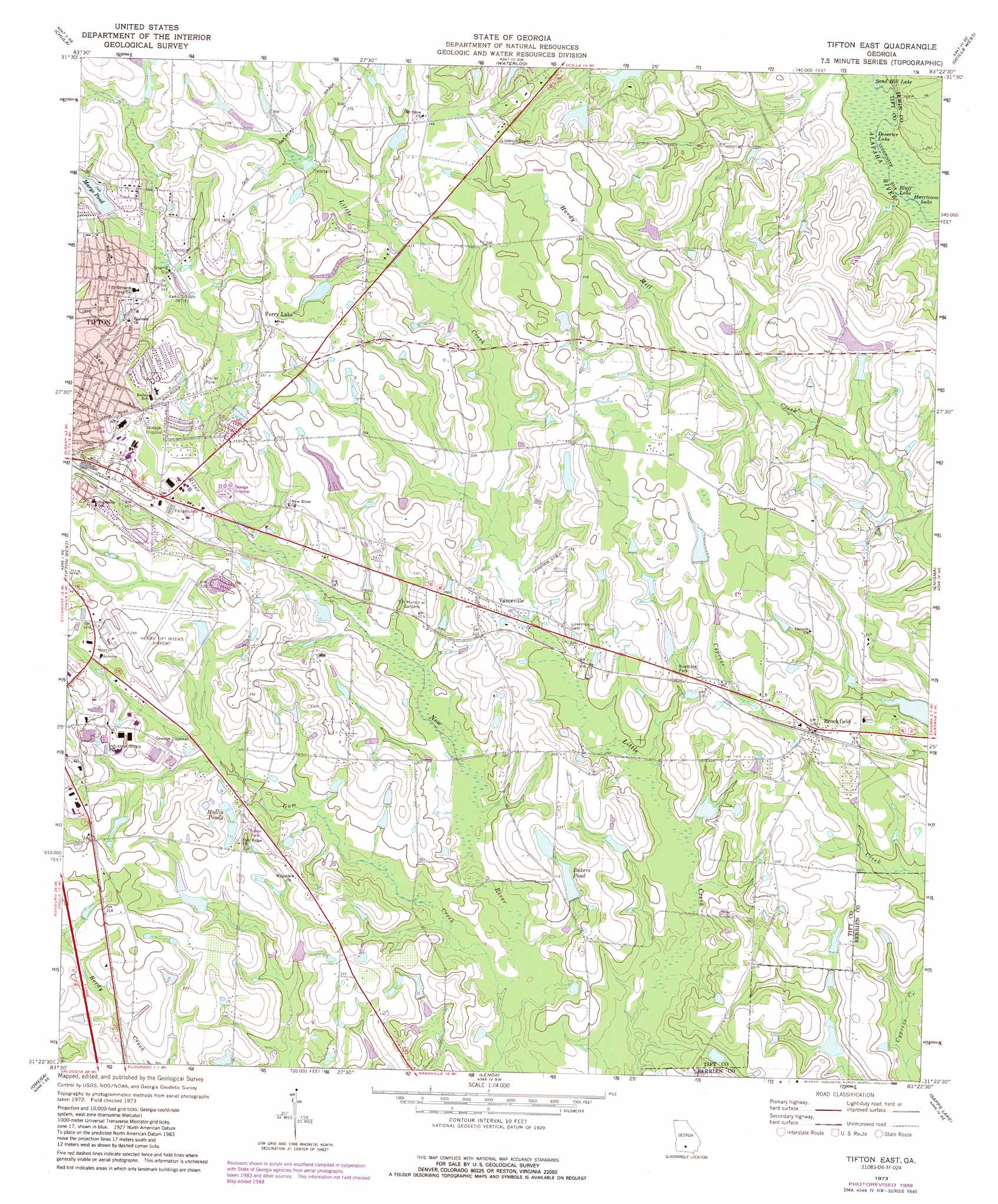
Tifton East Topo Map Georgia
To zoom in, hover over the map of Tifton East
USGS Topo Quad 31083d4 - 1:24,000 scale
| Topo Map Name: | Tifton East |
| USGS Topo Quad ID: | 31083d4 |
| Print Size: | ca. 21 1/4" wide x 27" high |
| Southeast Coordinates: | 31.375° N latitude / 83.375° W longitude |
| Map Center Coordinates: | 31.4375° N latitude / 83.4375° W longitude |
| U.S. State: | GA |
| Filename: | o31083d4.jpg |
| Download Map JPG Image: | Tifton East topo map 1:24,000 scale |
| Map Type: | Topographic |
| Topo Series: | 7.5´ |
| Map Scale: | 1:24,000 |
| Source of Map Images: | United States Geological Survey (USGS) |
| Alternate Map Versions: |
Tifton East GA 1973, updated 1976 Download PDF Buy paper map Tifton East GA 1973, updated 1988 Download PDF Buy paper map Tifton East GA 2011 Download PDF Buy paper map Tifton East GA 2014 Download PDF Buy paper map |
1:24,000 Topo Quads surrounding Tifton East
Ashburn |
Bethel |
Irwinville |
Fitzgerald West |
Fitzgerald East |
Sumner |
Chula |
Waterloo |
Ocilla West |
Ocilla East |
Ty Ty |
Tifton West |
Tifton East |
Enigma |
Alapaha |
Norman Park |
Omega |
Lenox |
Sapps Lake |
Tenmile Bay |
Pineboro |
Ellenton |
Adel |
Nashville West |
Nashville East |
> Back to 31083a1 at 1:100,000 scale
> Back to 31082a1 at 1:250,000 scale
> Back to U.S. Topo Maps home
Tifton East topo map: Gazetteer
Tifton East: Airports
Henry Tift Myers Airport elevation 106m 347′Tifton East: Dams
Bakers Pond Dam elevation 90m 295′Bany Lake Dam elevation 98m 321′
Bowen Lake Dam elevation 101m 331′
Brownlee Lake Dam elevation 97m 318′
Dillard Lake Dam elevation 94m 308′
Hawes Lake Dam elevation 99m 324′
Marys Pond Dam elevation 106m 347′
McAllister Lake Dam elevation 99m 324′
Stone Lake Dam elevation 88m 288′
Wilson Lake Dam elevation 95m 311′
Tifton East: Lakes
Bluff Lake elevation 76m 249′Deserter Lake elevation 76m 249′
Hurricane Lake elevation 76m 249′
Mullis Ponds elevation 97m 318′
Tifton East: Populated Places
Brookfield elevation 101m 331′Ferry Lake elevation 105m 344′
Linder elevation 105m 344′
Vanceville elevation 103m 337′
Tifton East: Reservoirs
Bakers Pond elevation 90m 295′Bany Lake elevation 98m 321′
Bowen Lake elevation 101m 331′
Brownlee Lake elevation 97m 318′
Dillard Lake elevation 94m 308′
Hawes Lake elevation 99m 324′
Marys Pond elevation 106m 347′
McAllister Lake elevation 99m 324′
Stone Lake elevation 88m 288′
Wilson Lake elevation 95m 311′
Tifton East: Streams
Gum Creek elevation 81m 265′Tifton East digital topo map on disk
Buy this Tifton East topo map showing relief, roads, GPS coordinates and other geographical features, as a high-resolution digital map file on DVD: