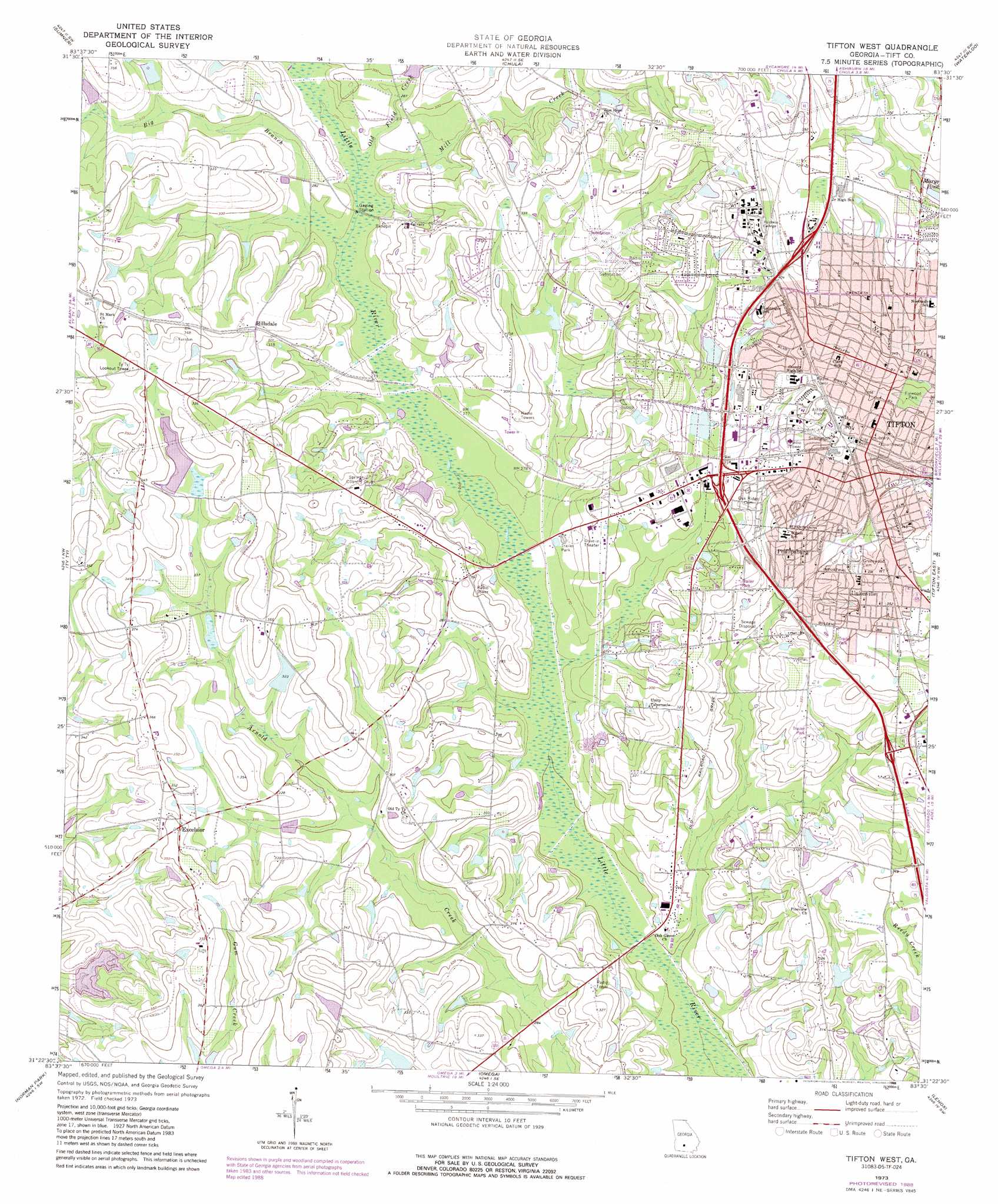
Tifton West Topo Map Georgia
To zoom in, hover over the map of Tifton West
USGS Topo Quad 31083d5 - 1:24,000 scale
| Topo Map Name: | Tifton West |
| USGS Topo Quad ID: | 31083d5 |
| Print Size: | ca. 21 1/4" wide x 27" high |
| Southeast Coordinates: | 31.375° N latitude / 83.5° W longitude |
| Map Center Coordinates: | 31.4375° N latitude / 83.5625° W longitude |
| U.S. State: | GA |
| Filename: | o31083d5.jpg |
| Download Map JPG Image: | Tifton West topo map 1:24,000 scale |
| Map Type: | Topographic |
| Topo Series: | 7.5´ |
| Map Scale: | 1:24,000 |
| Source of Map Images: | United States Geological Survey (USGS) |
| Alternate Map Versions: |
Tifton West GA 1973, updated 1976 Download PDF Buy paper map Tifton West GA 1973, updated 1988 Download PDF Buy paper map Tifton West GA 2011 Download PDF Buy paper map Tifton West GA 2014 Download PDF Buy paper map |
1:24,000 Topo Quads surrounding Tifton West
Cuffietown |
Ashburn |
Bethel |
Irwinville |
Fitzgerald West |
Sylvester |
Sumner |
Chula |
Waterloo |
Ocilla West |
Tempy |
Ty Ty |
Tifton West |
Tifton East |
Enigma |
Sigsbee |
Norman Park |
Omega |
Lenox |
Sapps Lake |
Moultrie |
Pineboro |
Ellenton |
Adel |
Nashville West |
> Back to 31083a1 at 1:100,000 scale
> Back to 31082a1 at 1:250,000 scale
> Back to U.S. Topo Maps home
Tifton West topo map: Gazetteer
Tifton West: Crossings
Exit 15 elevation 94m 308′Exit 16 elevation 100m 328′
Exit 17 elevation 97m 318′
Exit 18 elevation 98m 321′
Exit 19 elevation 100m 328′
Exit 20 elevation 100m 328′
Exit 21 elevation 113m 370′
Tifton West: Dams
Agrirama Lake Dam elevation 98m 321′Baldwin Lake Dam elevation 110m 360′
Bryan Lake Dam elevation 89m 291′
Fulwood Dam elevation 94m 308′
Jones Lake Dam elevation 100m 328′
Keen Lake Dam elevation 96m 314′
Marchant Lake Dam elevation 97m 318′
Moorman Lake Dam elevation 98m 321′
Ponder Lake Dam elevation 91m 298′
Spradley Lake Dam elevation 92m 301′
Tifton West: Parks
Fulwood Park elevation 103m 337′Tifton Commercial Historic District elevation 114m 374′
Tifton West: Populated Places
Excelsior elevation 107m 351′Hillsdale elevation 101m 331′
Iniss (historical) elevation 87m 285′
Kelltown elevation 80m 262′
Pebblebrook elevation 108m 354′
Phillipsburg elevation 96m 314′
Tifton elevation 107m 351′
Unionville elevation 107m 351′
Tifton West: Post Offices
Tifton Post Office elevation 113m 370′Tifton West: Reservoirs
Agrirama Lake elevation 98m 321′Baldwin Lake elevation 110m 360′
Bryan Lake elevation 89m 291′
Fullwood Lake elevation 94m 308′
Jones Lake elevation 100m 328′
Keen Lake elevation 96m 314′
Marchant Lake elevation 97m 318′
Moorman Lake elevation 98m 321′
Ponder Lake elevation 91m 298′
Spradley Lake elevation 92m 301′
Tifton West: Streams
Big Branch elevation 82m 269′Cow House Branch elevation 79m 259′
Mill Creek elevation 82m 269′
Old Field Creek elevation 82m 269′
Tifton West digital topo map on disk
Buy this Tifton West topo map showing relief, roads, GPS coordinates and other geographical features, as a high-resolution digital map file on DVD: