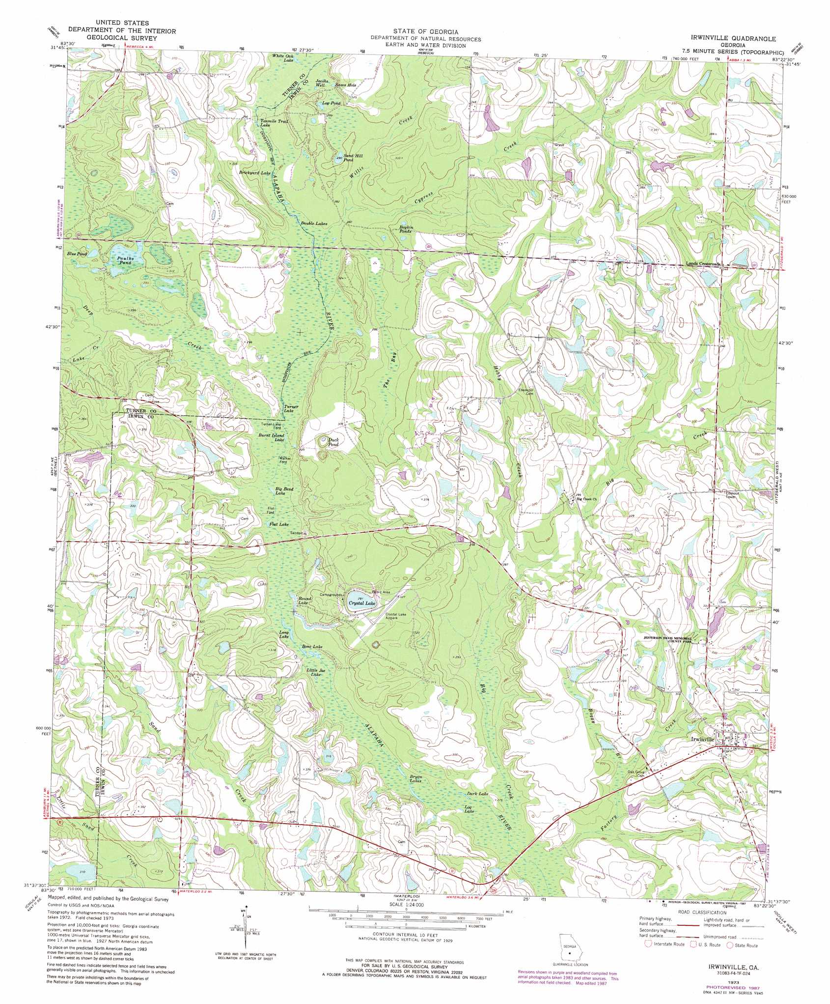
Irwinville Topo Map Georgia
To zoom in, hover over the map of Irwinville
USGS Topo Quad 31083f4 - 1:24,000 scale
| Topo Map Name: | Irwinville |
| USGS Topo Quad ID: | 31083f4 |
| Print Size: | ca. 21 1/4" wide x 27" high |
| Southeast Coordinates: | 31.625° N latitude / 83.375° W longitude |
| Map Center Coordinates: | 31.6875° N latitude / 83.4375° W longitude |
| U.S. State: | GA |
| Filename: | o31083f4.jpg |
| Download Map JPG Image: | Irwinville topo map 1:24,000 scale |
| Map Type: | Topographic |
| Topo Series: | 7.5´ |
| Map Scale: | 1:24,000 |
| Source of Map Images: | United States Geological Survey (USGS) |
| Alternate Map Versions: |
Irwinville GA 1973, updated 1975 Download PDF Buy paper map Irwinville GA 1973, updated 1987 Download PDF Buy paper map Irwinville GA 2011 Download PDF Buy paper map Irwinville GA 2014 Download PDF Buy paper map |
1:24,000 Topo Quads surrounding Irwinville
Penia |
Pitts |
Rochelle |
Abbeville South |
Rhine |
Arabi |
Amboy |
Rebecca |
Sibbie |
Queensland |
Ashburn |
Bethel |
Irwinville |
Fitzgerald West |
Fitzgerald East |
Sumner |
Chula |
Waterloo |
Ocilla West |
Ocilla East |
Ty Ty |
Tifton West |
Tifton East |
Enigma |
Alapaha |
> Back to 31083e1 at 1:100,000 scale
> Back to 31082a1 at 1:250,000 scale
> Back to U.S. Topo Maps home
Irwinville topo map: Gazetteer
Irwinville: Airports
Crystal Lake Airpark elevation 94m 308′Irwinville: Crossings
Flat Ford elevation 84m 275′Flat Ford elevation 85m 278′
Turner Lake Ford elevation 84m 275′
Walker Ford elevation 84m 275′
Irwinville: Dams
Bowen Lake Dam elevation 99m 324′Brown Lake Dam elevation 91m 298′
Clements Lake Dam elevation 100m 328′
Fletcher Lake Dam elevation 92m 301′
Fuller Lake Dam elevation 96m 314′
Land Lake Dam elevation 105m 344′
McIntyre Lake Dam elevation 97m 318′
Oneal Wynn Lake Dam elevation 101m 331′
Roberts Lake Dam elevation 105m 344′
Stripling Lake Dam elevation 99m 324′
Walker Lake Dam elevation 89m 291′
Irwinville: Lakes
Big Bend Lake elevation 84m 275′Blue Pond elevation 90m 295′
Bone Lake elevation 81m 265′
Boykin Ponds elevation 96m 314′
Brickyard Lake elevation 85m 278′
Bryan Lakes elevation 81m 265′
Burnt Island Lake elevation 84m 275′
Coleman Pond elevation 84m 275′
Crystal Lake elevation 89m 291′
Dark Lake elevation 81m 265′
Double Lakes elevation 85m 278′
Duck Pond elevation 87m 285′
Flat Lake elevation 84m 275′
Jacobs Well elevation 88m 288′
Little Joe Lake elevation 81m 265′
Log Lake elevation 81m 265′
Log Pond elevation 88m 288′
Long Lake elevation 82m 269′
Paulks Pond elevation 90m 295′
Ross Lake elevation 84m 275′
Round Lake elevation 84m 275′
Sams Hole elevation 98m 321′
Sand Hill Pond elevation 91m 298′
Tenmile Trail Lake elevation 85m 278′
Turner Lake elevation 84m 275′
White Oak Lake elevation 87m 285′
Irwinville: Parks
Jefferson Davis Memorial State Park elevation 96m 314′Irwinville: Populated Places
Irwinville elevation 102m 334′Lands Crossroads elevation 106m 347′
Irwinville: Post Offices
Irwinville Post Office elevation 102m 334′Irwinville: Reservoirs
Bowen Lake elevation 99m 324′Brown Lake elevation 91m 298′
Clements Lake elevation 100m 328′
Fletcher Lake elevation 92m 301′
Fuller Lake elevation 96m 314′
Land Lake elevation 105m 344′
McIntyre Lake elevation 97m 318′
Oneal Wynn Lake elevation 101m 331′
Roberts Lake elevation 105m 344′
Stripling Lake elevation 99m 324′
Walker Lake elevation 89m 291′
Irwinville: Streams
Big Creek elevation 81m 265′Boggy Branch elevation 85m 278′
Cypress Creek elevation 84m 275′
Deep Creek elevation 85m 278′
Factory Creek elevation 81m 265′
Hobby Creek elevation 85m 278′
Lake Creek elevation 84m 275′
Willis Creek elevation 85m 278′
Irwinville: Swamps
The Bay elevation 86m 282′Irwinville digital topo map on disk
Buy this Irwinville topo map showing relief, roads, GPS coordinates and other geographical features, as a high-resolution digital map file on DVD: