Penia Topo Map Georgia
To zoom in, hover over the map of Penia
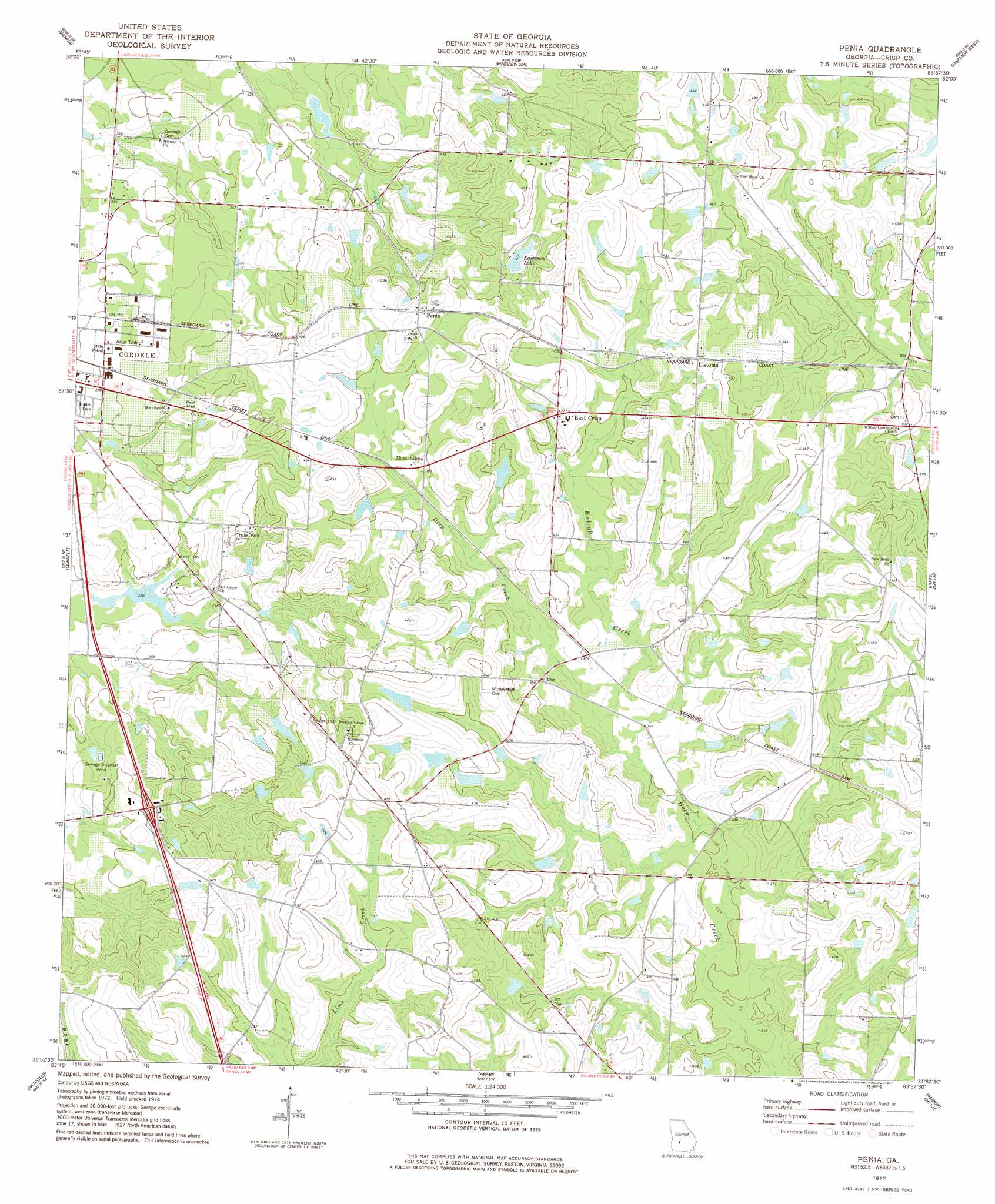
USGS Topo Quad 31083h6 - 1:24,000 scale
| Topo Map Name: | Penia |
| USGS Topo Quad ID: | 31083h6 |
| Print Size: | ca. 21 1/4" wide x 27" high |
| Southeast Coordinates: | 31.875° N latitude / 83.625° W longitude |
| Map Center Coordinates: | 31.9375° N latitude / 83.6875° W longitude |
| U.S. State: | GA |
| Filename: | o31083h6.jpg |
| Download Map JPG Image: | Penia topo map 1:24,000 scale |
| Map Type: | Topographic |
| Topo Series: | 7.5´ |
| Map Scale: | 1:24,000 |
| Source of Map Images: | United States Geological Survey (USGS) |
| Alternate Map Versions: |
Penia GA 1977, updated 1977 Download PDF Buy paper map Penia GA 2011 Download PDF Buy paper map Penia GA 2014 Download PDF Buy paper map |
1:24,000 Topo Quads surrounding Penia
Byromville |
Pinehurst |
Pineview Nw |
Finleyson West |
Finleyson East |
Drayton |
Vienna |
Pineview Sw |
Pineview West |
Pineview East |
Cobb |
Cordele |
Penia |
Pitts |
Rochelle |
Warwick |
Pateville |
Arabi |
Amboy |
Rebecca |
Doles |
Cuffietown |
Ashburn |
Bethel |
Irwinville |
> Back to 31083e1 at 1:100,000 scale
> Back to 31082a1 at 1:250,000 scale
> Back to U.S. Topo Maps home
Penia topo map: Gazetteer
Penia: Crossings
Exit 31 elevation 117m 383′Exit 32 elevation 110m 360′
Penia: Dams
Benefield Lake Dam elevation 133m 436′Carden Pond Dam elevation 113m 370′
Crane Lake Dam elevation 102m 334′
Eastwood Lake Dam elevation 124m 406′
Matthews Lake Dam elevation 111m 364′
Wells Lake Dam elevation 100m 328′
Williams Lake Dam One elevation 119m 390′
Williams Lake Dam Three elevation 129m 423′
Williams Lake Dam Two elevation 125m 410′
Penia: Populated Places
East Crisp elevation 129m 423′Listonia elevation 134m 439′
McKenzie elevation 113m 370′
Musselwhite elevation 119m 390′
Penia elevation 131m 429′
Williford (historical) elevation 114m 374′
Penia: Reservoirs
Carden Pond elevation 113m 370′Crane Lake elevation 102m 334′
Eastwood Lake elevation 124m 406′
Matthews Lake elevation 111m 364′
Williams Lake elevation 119m 390′
Williams Lake Three elevation 129m 423′
Williams Lake Two elevation 125m 410′
Penia: Streams
Redoak Creek elevation 108m 354′Penia digital topo map on disk
Buy this Penia topo map showing relief, roads, GPS coordinates and other geographical features, as a high-resolution digital map file on DVD: