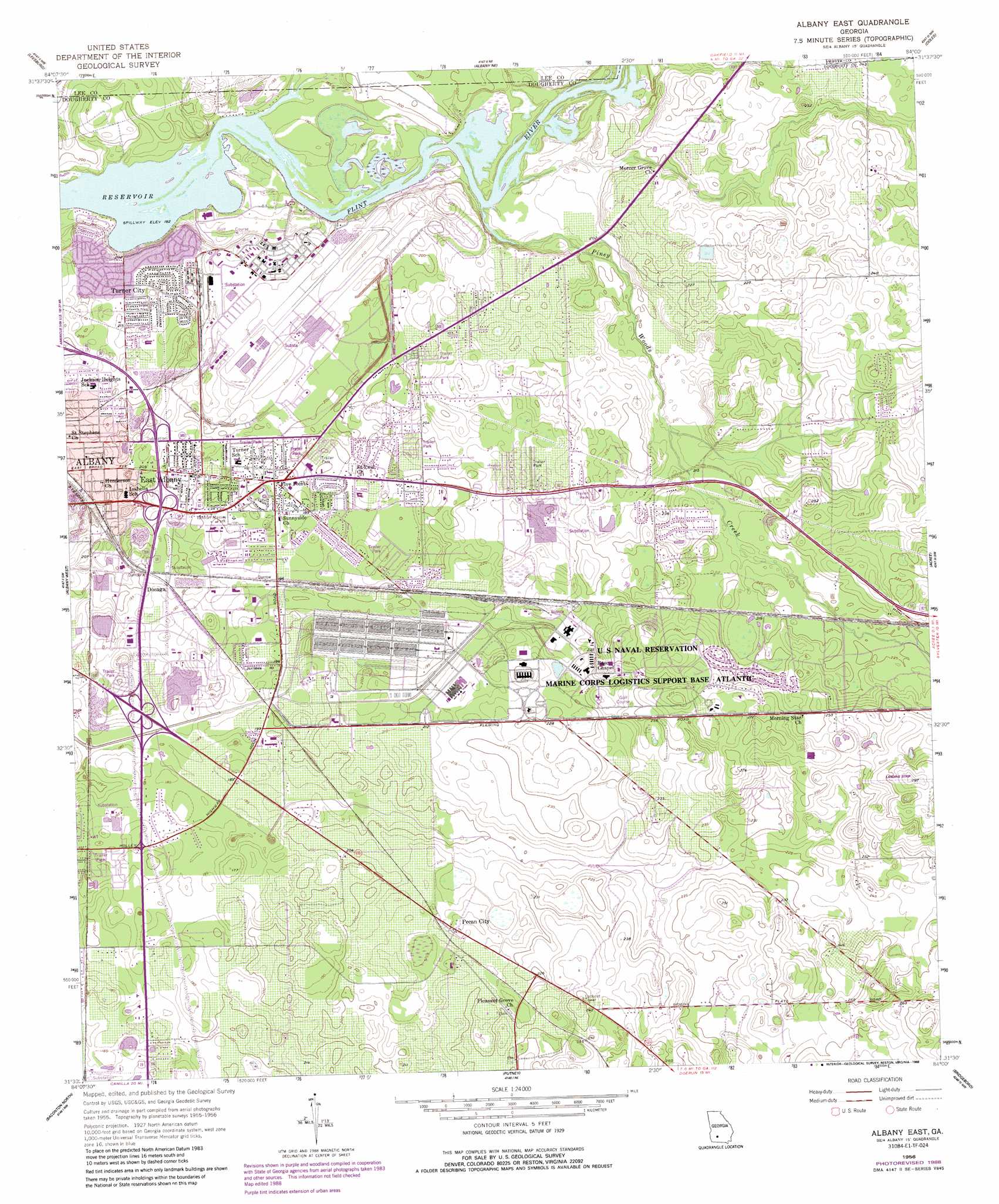
Albany East Topo Map Georgia
To zoom in, hover over the map of Albany East
USGS Topo Quad 31084e1 - 1:24,000 scale
| Topo Map Name: | Albany East |
| USGS Topo Quad ID: | 31084e1 |
| Print Size: | ca. 21 1/4" wide x 27" high |
| Southeast Coordinates: | 31.5° N latitude / 84° W longitude |
| Map Center Coordinates: | 31.5625° N latitude / 84.0625° W longitude |
| U.S. State: | GA |
| Filename: | o31084e1.jpg |
| Download Map JPG Image: | Albany East topo map 1:24,000 scale |
| Map Type: | Topographic |
| Topo Series: | 7.5´ |
| Map Scale: | 1:24,000 |
| Source of Map Images: | United States Geological Survey (USGS) |
| Alternate Map Versions: |
Albany East GA 1956, updated 1957 Download PDF Buy paper map Albany East GA 1956, updated 1965 Download PDF Buy paper map Albany East GA 1956, updated 1973 Download PDF Buy paper map Albany East GA 1956, updated 1988 Download PDF Buy paper map Albany East GA 2011 Download PDF Buy paper map Albany East GA 2014 Download PDF Buy paper map |
1:24,000 Topo Quads surrounding Albany East
Bronwood |
Neyami |
Leslie Se |
Warwick |
Pateville |
Sasser |
Leesburg |
Albany Ne |
Doles |
Cuffietown |
Pretoria |
Albany West |
Albany East |
Acree |
Sylvester |
Red Store Crossroads |
Baconton North |
Putney |
Bridgeboro |
Tempy |
Newton |
Baconton South |
Sale City |
Doerun |
Sigsbee |
> Back to 31084e1 at 1:100,000 scale
> Back to 31084a1 at 1:250,000 scale
> Back to U.S. Topo Maps home
Albany East topo map: Gazetteer
Albany East: Airports
Double 'O' Farm Airport elevation 89m 291′Albany East: Parks
Piney Woods Park elevation 68m 223′Tallulah Massey Park elevation 60m 196′
Albany East: Populated Places
Avert Acres elevation 57m 187′Baker Heights elevation 63m 206′
Brierwood elevation 59m 193′
Butler Subdivision elevation 57m 187′
Catalina Beach Estates elevation 64m 209′
Dosaga elevation 60m 196′
East Albany elevation 62m 203′
Eastgate elevation 60m 196′
Eleanor Village elevation 58m 190′
Five Points elevation 59m 193′
Grove Park elevation 59m 193′
Isabella Heights elevation 64m 209′
Jackson Heights elevation 63m 206′
Mayfair elevation 62m 203′
Oak Grove Estates Mobile Home Park elevation 53m 173′
Oakdale elevation 60m 196′
Paradise Village Mobile Home Park elevation 55m 180′
Pecan City elevation 67m 219′
Pecan Haven elevation 61m 200′
Pecan Terrace elevation 59m 193′
Pineview elevation 63m 206′
Powell Place elevation 59m 193′
Rolling Groves elevation 63m 206′
Ruark (historical) elevation 63m 206′
Sandalwood elevation 59m 193′
Stroms elevation 59m 193′
Sylvandale elevation 65m 213′
Tompkins Village elevation 59m 193′
Turner City elevation 64m 209′
Woodland Acres elevation 64m 209′
Albany East: Streams
Piney Woods Creek elevation 55m 180′Albany East digital topo map on disk
Buy this Albany East topo map showing relief, roads, GPS coordinates and other geographical features, as a high-resolution digital map file on DVD:
Gulf Coast (LA, MS, AL, FL) & Southwestern Georgia
Buy digital topo maps: Gulf Coast (LA, MS, AL, FL) & Southwestern Georgia
 & Southwestern Georgia map DVD")