Zetto Topo Map Georgia
To zoom in, hover over the map of Zetto
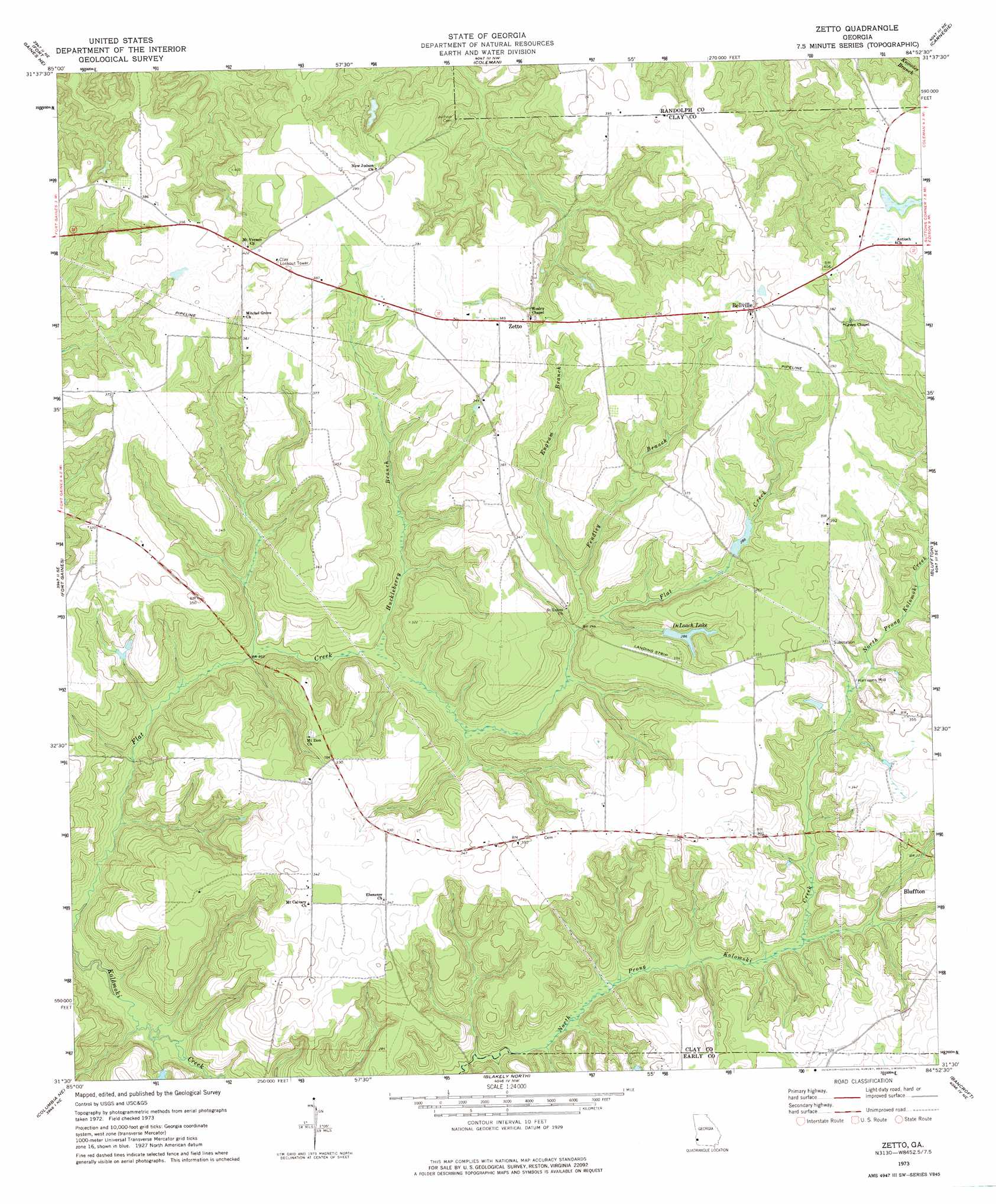
USGS Topo Quad 31084e8 - 1:24,000 scale
| Topo Map Name: | Zetto |
| USGS Topo Quad ID: | 31084e8 |
| Print Size: | ca. 21 1/4" wide x 27" high |
| Southeast Coordinates: | 31.5° N latitude / 84.875° W longitude |
| Map Center Coordinates: | 31.5625° N latitude / 84.9375° W longitude |
| U.S. State: | GA |
| Filename: | o31084e8.jpg |
| Download Map JPG Image: | Zetto topo map 1:24,000 scale |
| Map Type: | Topographic |
| Topo Series: | 7.5´ |
| Map Scale: | 1:24,000 |
| Source of Map Images: | United States Geological Survey (USGS) |
| Alternate Map Versions: |
Zetto GA 1973, updated 1975 Download PDF Buy paper map Zetto GA 2011 Download PDF Buy paper map Zetto GA 2014 Download PDF Buy paper map |
1:24,000 Topo Quads surrounding Zetto
Eufaula South |
Hatcher |
Morris |
Cuthbert |
Brooksville |
Fort Gaines Nw |
Fort Gaines Ne |
Coleman |
Carnegie |
Martins Crossroads |
Abbeville East |
Fort Gaines |
Zetto |
Bluffton |
Edison |
Haleburg |
Columbia Ne |
Blakely North |
Bancroft |
Arlington |
Sigma |
Columbia |
Blakely South |
Hentown |
Damascus |
> Back to 31084e1 at 1:100,000 scale
> Back to 31084a1 at 1:250,000 scale
> Back to U.S. Topo Maps home
Zetto topo map: Gazetteer
Zetto: Dams
Deloach Lake Dam elevation 102m 334′Fendley Lake Dam elevation 106m 347′
Fendley Lake Dam elevation 98m 321′
Mckemie Lake Dam elevation 84m 275′
Mckemie Lake North Dam elevation 85m 278′
Zetto: Populated Places
Bellville elevation 122m 400′Harrisons Mill elevation 83m 272′
Zetto elevation 117m 383′
Zetto: Reservoirs
DeLoach Lake elevation 82m 269′Fendley Lake elevation 98m 321′
Fendley Lake elevation 106m 347′
Mckemie Lake elevation 84m 275′
Mckenie Lake North elevation 85m 278′
Zetto: Streams
Engram Branch elevation 75m 246′Fendley Branch elevation 73m 239′
Huckleberry Branch elevation 59m 193′
Zetto digital topo map on disk
Buy this Zetto topo map showing relief, roads, GPS coordinates and other geographical features, as a high-resolution digital map file on DVD:
Gulf Coast (LA, MS, AL, FL) & Southwestern Georgia
Buy digital topo maps: Gulf Coast (LA, MS, AL, FL) & Southwestern Georgia
 & Southwestern Georgia map DVD")