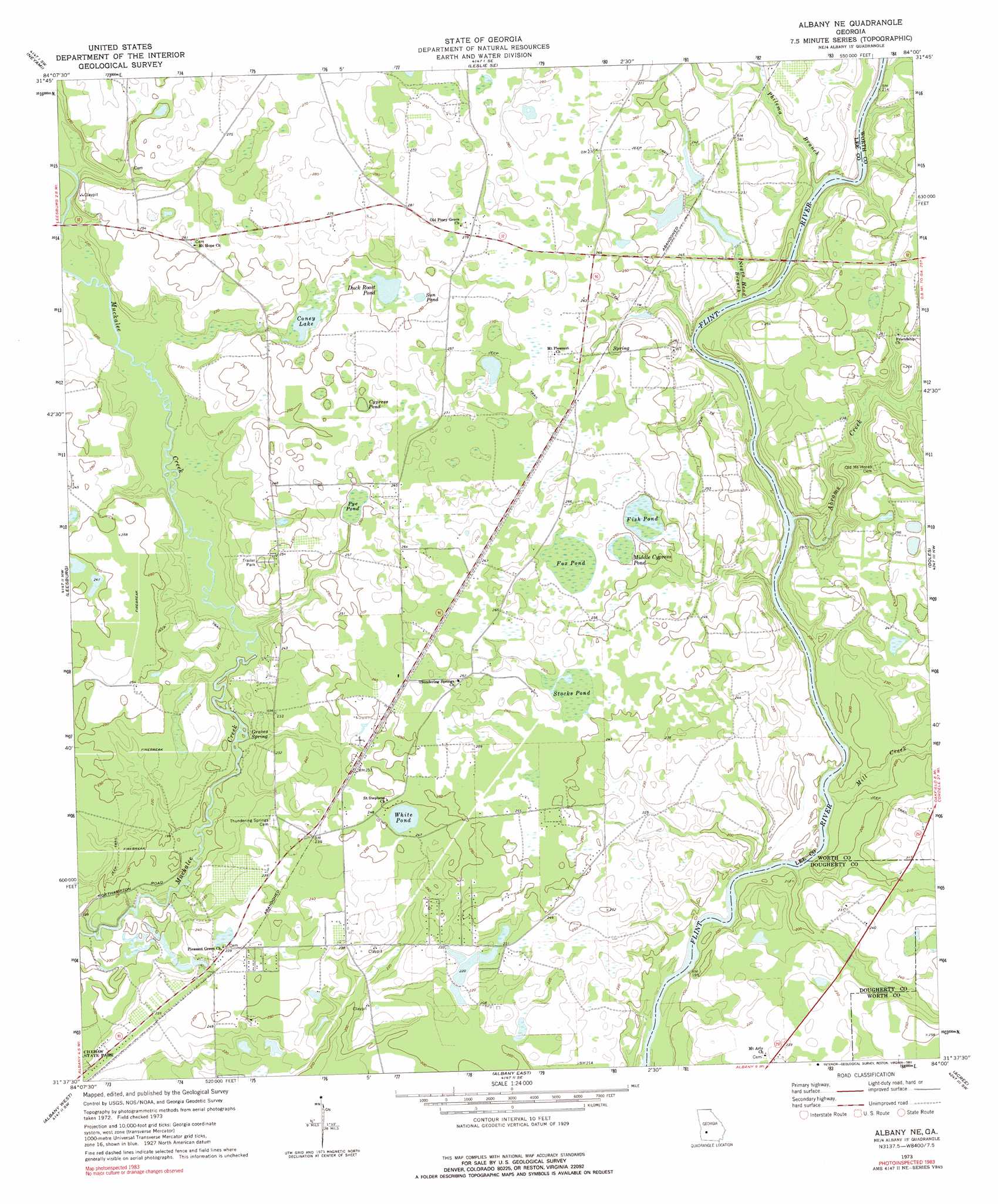
Albany Ne Topo Map Georgia
To zoom in, hover over the map of Albany Ne
USGS Topo Quad 31084f1 - 1:24,000 scale
| Topo Map Name: | Albany Ne |
| USGS Topo Quad ID: | 31084f1 |
| Print Size: | ca. 21 1/4" wide x 27" high |
| Southeast Coordinates: | 31.625° N latitude / 84° W longitude |
| Map Center Coordinates: | 31.6875° N latitude / 84.0625° W longitude |
| U.S. State: | GA |
| Filename: | o31084f1.jpg |
| Download Map JPG Image: | Albany Ne topo map 1:24,000 scale |
| Map Type: | Topographic |
| Topo Series: | 7.5´ |
| Map Scale: | 1:24,000 |
| Source of Map Images: | United States Geological Survey (USGS) |
| Alternate Map Versions: |
Albany NE GA 1973, updated 1975 Download PDF Buy paper map Albany NE GA 1973, updated 1991 Download PDF Buy paper map Albany NE GA 2011 Download PDF Buy paper map Albany NE GA 2014 Download PDF Buy paper map |
1:24,000 Topo Quads surrounding Albany Ne
Smithville West |
Smithville East |
Leslie |
Cobb |
Cordele |
Bronwood |
Neyami |
Leslie Se |
Warwick |
Pateville |
Sasser |
Leesburg |
Albany Ne |
Doles |
Cuffietown |
Pretoria |
Albany West |
Albany East |
Acree |
Sylvester |
Red Store Crossroads |
Baconton North |
Putney |
Bridgeboro |
Tempy |
> Back to 31084e1 at 1:100,000 scale
> Back to 31084a1 at 1:250,000 scale
> Back to U.S. Topo Maps home
Albany Ne topo map: Gazetteer
Albany Ne: Bridges
Forrester Bridge elevation 67m 219′Albany Ne: Lakes
Coney Lake elevation 71m 232′Cypress Pond elevation 76m 249′
Duck Roost Pond elevation 75m 246′
Fish Pond elevation 75m 246′
Fox Pond elevation 78m 255′
Middle Cypress Pond elevation 75m 246′
Pye Pond elevation 75m 246′
Stocks Pond elevation 78m 255′
Sun Pond elevation 76m 249′
White Pond elevation 75m 246′
Albany Ne: Populated Places
Beloit elevation 78m 255′Chehaw elevation 81m 265′
Nutview (historical) elevation 73m 239′
Stocks elevation 73m 239′
Stocks (historical) elevation 73m 239′
Albany Ne: Springs
Graves Spring elevation 61m 200′Thundering Spring elevation 67m 219′
Albany Ne: Streams
Abrams Creek elevation 58m 190′Gin Branch elevation 57m 187′
Mill Creek elevation 57m 187′
Negro Head Branch elevation 60m 196′
Philema Branch elevation 60m 196′
Albany Ne digital topo map on disk
Buy this Albany Ne topo map showing relief, roads, GPS coordinates and other geographical features, as a high-resolution digital map file on DVD:
Gulf Coast (LA, MS, AL, FL) & Southwestern Georgia
Buy digital topo maps: Gulf Coast (LA, MS, AL, FL) & Southwestern Georgia
 & Southwestern Georgia map DVD")