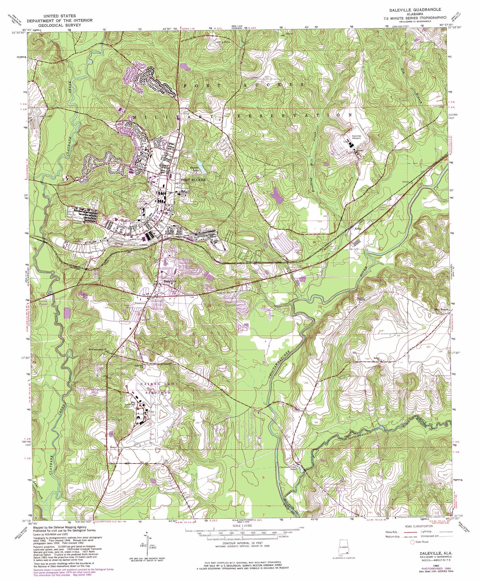
Daleville Topo Map Alabama
To zoom in, hover over the map of Daleville
USGS Topo Quad 31085c6 - 1:24,000 scale
| Topo Map Name: | Daleville |
| USGS Topo Quad ID: | 31085c6 |
| Print Size: | ca. 21 1/4" wide x 27" high |
| Southeast Coordinates: | 31.25° N latitude / 85.625° W longitude |
| Map Center Coordinates: | 31.3125° N latitude / 85.6875° W longitude |
| U.S. State: | AL |
| Filename: | o31085c6.jpg |
| Download Map JPG Image: | Daleville topo map 1:24,000 scale |
| Map Type: | Topographic |
| Topo Series: | 7.5´ |
| Map Scale: | 1:24,000 |
| Source of Map Images: | United States Geological Survey (USGS) |
| Alternate Map Versions: |
Daleville AL 1960, updated 1964 Download PDF Buy paper map Daleville AL 1960, updated 1977 Download PDF Buy paper map Daleville AL 1960, updated 1981 Download PDF Buy paper map Daleville AL 2011 Download PDF Buy paper map Daleville AL 2014 Download PDF Buy paper map |
1:24,000 Topo Quads surrounding Daleville
Victoria |
Brundidge Se |
Ariton |
Skipperville |
Clopton |
New Brockton |
Enterprise Ne |
Ozark |
Ewell |
Echo |
Goodman |
Enterprise |
Daleville |
Pinckard |
Midland City |
Coffee Springs |
Bellwood |
Clayhatchee |
Malvern |
Dothan West |
Geneva West |
Geneva East |
Hartford |
Slocomb |
Madrid |
> Back to 31085a1 at 1:100,000 scale
> Back to 31084a1 at 1:250,000 scale
> Back to U.S. Topo Maps home
Daleville topo map: Gazetteer
Daleville: Airports
Hanchey AHP Airport elevation 75m 246′Knox Heliport elevation 68m 223′
Lowe AHP Airport elevation 66m 216′
Daleville: Bridges
Burnt Mill Bridge elevation 37m 121′Golden Bridge elevation 44m 144′
Lower Iron Bridge elevation 40m 131′
Snell Bridge elevation 43m 141′
Daleville: Dams
Fort Rucker Dam elevation 70m 229′Daleville: Populated Places
Allen Heights elevation 111m 364′Bowden Terrace elevation 103m 337′
Daleville elevation 102m 334′
Five Points elevation 104m 341′
Kelly elevation 50m 164′
Munson Heights elevation 98m 321′
Daleville: Post Offices
Daleville Post Office elevation 102m 334′Fort Rucker Post Office elevation 108m 354′
Daleville: Reservoirs
Beaver Lake elevation 76m 249′Daleville: Streams
Brooking Mill Creek elevation 43m 141′Byrds Branch elevation 44m 144′
Cowpen Creek elevation 46m 150′
Four Mile Creek elevation 52m 170′
Harrand Creek elevation 46m 150′
Line Creek elevation 42m 137′
Little Choctawhatchee River elevation 35m 114′
Peters Branch elevation 35m 114′
Snell Mill Branch elevation 42m 137′
Steep Head Creek elevation 49m 160′
Daleville: Wells
Choctawhatchee Wells elevation 46m 150′Daleville digital topo map on disk
Buy this Daleville topo map showing relief, roads, GPS coordinates and other geographical features, as a high-resolution digital map file on DVD:
Gulf Coast (LA, MS, AL, FL) & Southwestern Georgia
Buy digital topo maps: Gulf Coast (LA, MS, AL, FL) & Southwestern Georgia
 & Southwestern Georgia map DVD")