Brundidge Se Topo Map Alabama
To zoom in, hover over the map of Brundidge Se
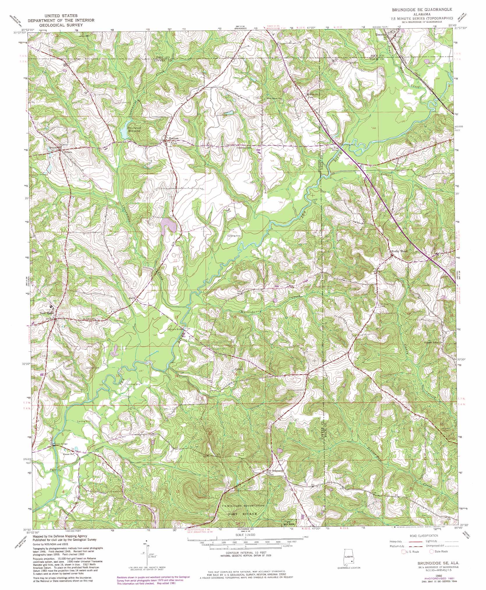
USGS Topo Quad 31085e7 - 1:24,000 scale
| Topo Map Name: | Brundidge Se |
| USGS Topo Quad ID: | 31085e7 |
| Print Size: | ca. 21 1/4" wide x 27" high |
| Southeast Coordinates: | 31.5° N latitude / 85.75° W longitude |
| Map Center Coordinates: | 31.5625° N latitude / 85.8125° W longitude |
| U.S. State: | AL |
| Filename: | o31085e7.jpg |
| Download Map JPG Image: | Brundidge Se topo map 1:24,000 scale |
| Map Type: | Topographic |
| Topo Series: | 7.5´ |
| Map Scale: | 1:24,000 |
| Source of Map Images: | United States Geological Survey (USGS) |
| Alternate Map Versions: |
Brundidge SE AL 1960, updated 1963 Download PDF Buy paper map Brundidge SE AL 1960, updated 1981 Download PDF Buy paper map Brundidge SE AL 2011 Download PDF Buy paper map Brundidge SE AL 2014 Download PDF Buy paper map |
1:24,000 Topo Quads surrounding Brundidge Se
Youngblood |
Troy |
Banks |
Josie |
Louisville |
Goshen |
Brundidge Nw |
Brundidge |
Elamville |
Clio |
Bluff Springs |
Victoria |
Brundidge Se |
Ariton |
Skipperville |
Elba |
New Brockton |
Enterprise Ne |
Ozark |
Ewell |
Ino |
Goodman |
Enterprise |
Daleville |
Pinckard |
> Back to 31085e1 at 1:100,000 scale
> Back to 31084a1 at 1:250,000 scale
> Back to U.S. Topo Maps home
Brundidge Se topo map: Gazetteer
Brundidge Se: Bridges
Coles Bridge elevation 70m 229′Johnsons Bridge elevation 73m 239′
Pea River Bridge elevation 79m 259′
Brundidge Se: Dams
Roeton Mill Pond Dam elevation 86m 282′Brundidge Se: Lakes
Prestwood Millpond elevation 86m 282′Brundidge Se: Populated Places
Frisco elevation 120m 393′Java elevation 90m 295′
New Hope elevation 112m 367′
Rocky Head elevation 144m 472′
Roeton elevation 122m 400′
Tennille elevation 93m 305′
Brundidge Se: Streams
Bowden Mill Creek elevation 79m 259′Butts Branch elevation 82m 269′
Camp Branch elevation 98m 321′
Clearwater Creek elevation 73m 239′
Gin Branch elevation 76m 249′
Halls Creek elevation 70m 229′
Huckleberry Creek elevation 73m 239′
Johnson Creek elevation 70m 229′
Kiser Mill Creek elevation 70m 229′
Kiser Mill Creek elevation 70m 229′
Lithco Creek elevation 76m 249′
Pitman Branch elevation 79m 259′
Roe Branch elevation 85m 278′
Tanyard Branch elevation 85m 278′
Taynard Branch elevation 76m 249′
West Clearwater Creek elevation 91m 298′
Brundidge Se digital topo map on disk
Buy this Brundidge Se topo map showing relief, roads, GPS coordinates and other geographical features, as a high-resolution digital map file on DVD:
Gulf Coast (LA, MS, AL, FL) & Southwestern Georgia
Buy digital topo maps: Gulf Coast (LA, MS, AL, FL) & Southwestern Georgia
 & Southwestern Georgia map DVD")