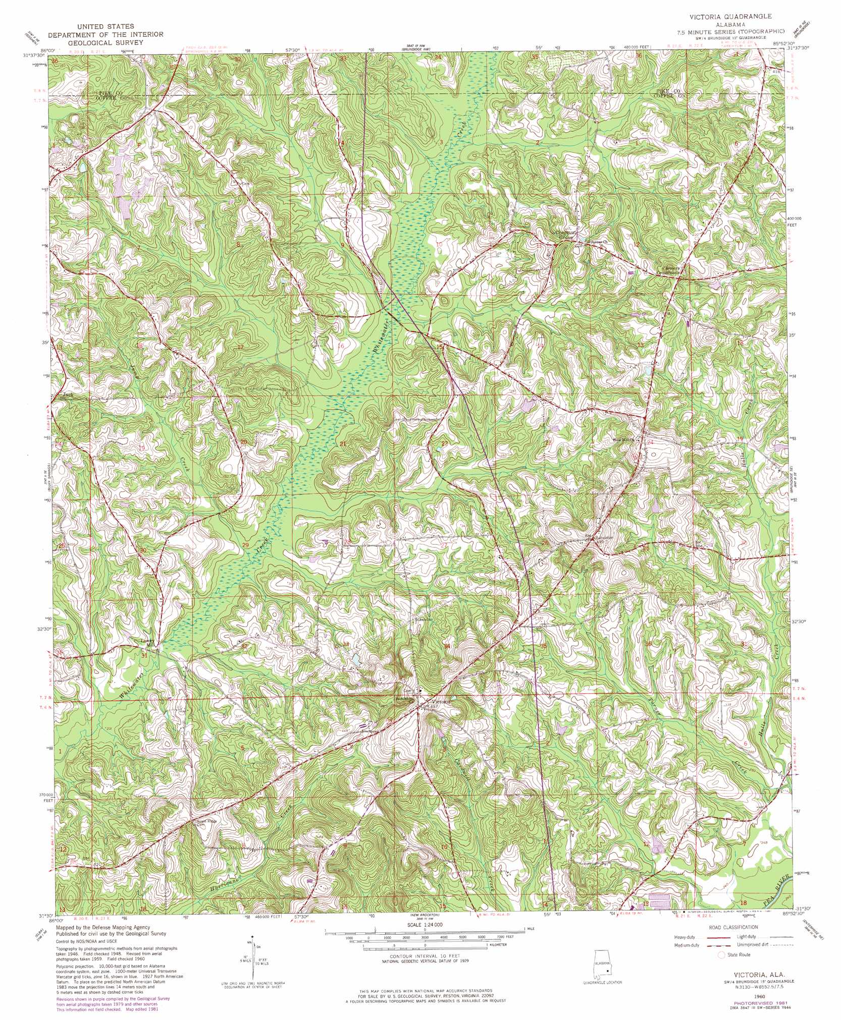
Victoria Topo Map Alabama
To zoom in, hover over the map of Victoria
USGS Topo Quad 31085e8 - 1:24,000 scale
| Topo Map Name: | Victoria |
| USGS Topo Quad ID: | 31085e8 |
| Print Size: | ca. 21 1/4" wide x 27" high |
| Southeast Coordinates: | 31.5° N latitude / 85.875° W longitude |
| Map Center Coordinates: | 31.5625° N latitude / 85.9375° W longitude |
| U.S. State: | AL |
| Filename: | o31085e8.jpg |
| Download Map JPG Image: | Victoria topo map 1:24,000 scale |
| Map Type: | Topographic |
| Topo Series: | 7.5´ |
| Map Scale: | 1:24,000 |
| Source of Map Images: | United States Geological Survey (USGS) |
| Alternate Map Versions: |
Victoria AL 1960, updated 1963 Download PDF Buy paper map Victoria AL 1960, updated 1981 Download PDF Buy paper map Victoria AL 2011 Download PDF Buy paper map Victoria AL 2014 Download PDF Buy paper map |
1:24,000 Topo Quads surrounding Victoria
Petrey |
Youngblood |
Troy |
Banks |
Josie |
Glenwood |
Goshen |
Brundidge Nw |
Brundidge |
Elamville |
Bullock |
Bluff Springs |
Victoria |
Brundidge Se |
Ariton |
Danleys Crossroads |
Elba |
New Brockton |
Enterprise Ne |
Ozark |
Opp East |
Ino |
Goodman |
Enterprise |
Daleville |
> Back to 31085e1 at 1:100,000 scale
> Back to 31084a1 at 1:250,000 scale
> Back to U.S. Topo Maps home
Victoria topo map: Gazetteer
Victoria: Parks
Victoria Ball Park elevation 156m 511′Victoria: Populated Places
Arcus elevation 136m 446′Chestnut Grove elevation 120m 393′
Clowers Crossroads elevation 125m 410′
Lowry Mill elevation 74m 242′
Victoria elevation 150m 492′
Wilkinstown elevation 127m 416′
Victoria: Post Offices
Busbyville Post Office (historical) elevation 123m 403′Indian Head Post Office (historical) elevation 153m 501′
Victoria: Streams
Cedar Creek elevation 80m 262′Chapman Creek elevation 77m 252′
Dry Creek elevation 82m 269′
Gin Branch elevation 78m 255′
Hog Creek elevation 80m 262′
Jump Creek elevation 71m 232′
Shoal Creek elevation 70m 229′
Turner Branch elevation 74m 242′
Turner Creek elevation 73m 239′
Wolf Creek elevation 81m 265′
Victoria digital topo map on disk
Buy this Victoria topo map showing relief, roads, GPS coordinates and other geographical features, as a high-resolution digital map file on DVD:
Gulf Coast (LA, MS, AL, FL) & Southwestern Georgia
Buy digital topo maps: Gulf Coast (LA, MS, AL, FL) & Southwestern Georgia
 & Southwestern Georgia map DVD")