Lawrenceville Topo Map Alabama
To zoom in, hover over the map of Lawrenceville
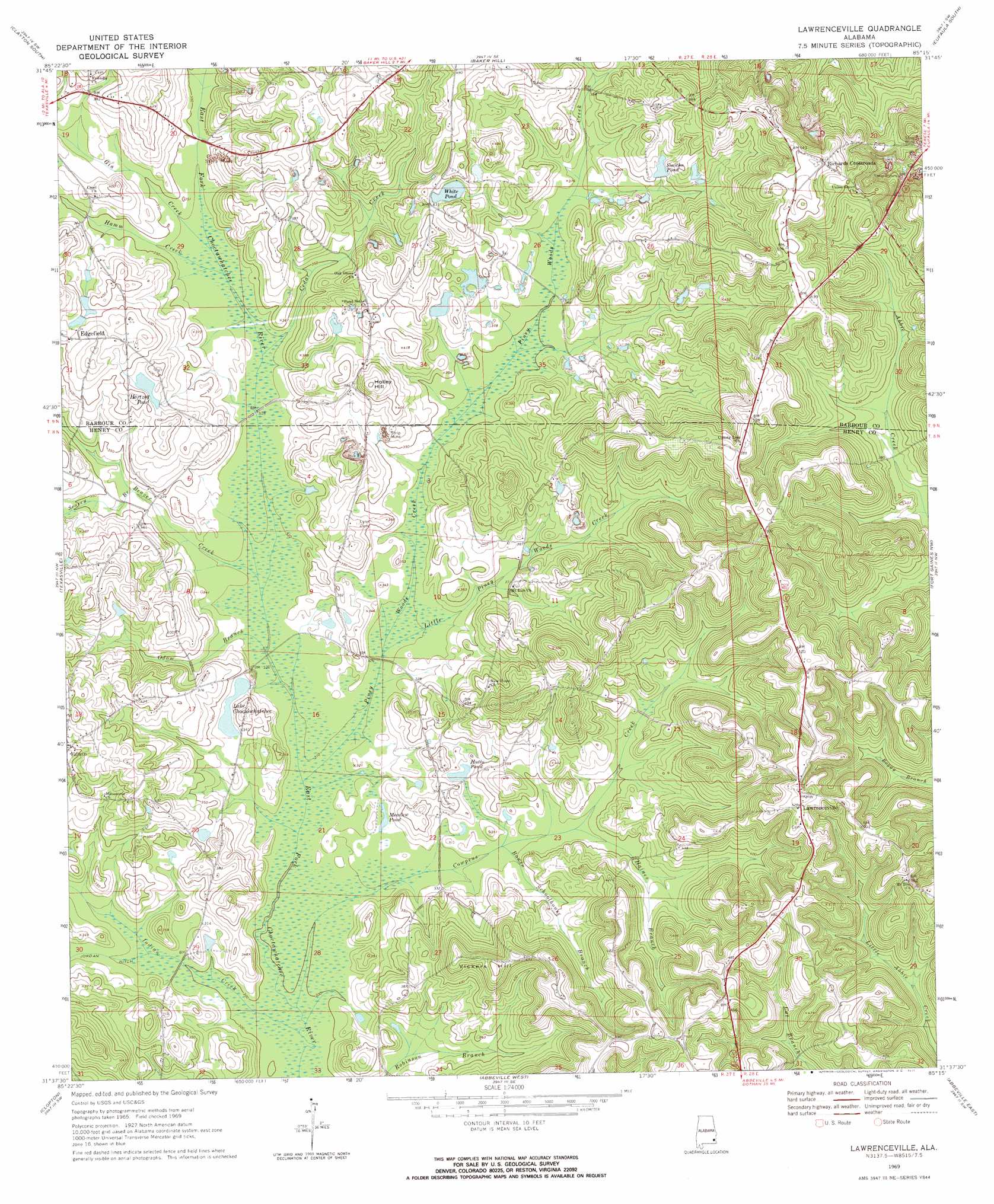
USGS Topo Quad 31085f3 - 1:24,000 scale
| Topo Map Name: | Lawrenceville |
| USGS Topo Quad ID: | 31085f3 |
| Print Size: | ca. 21 1/4" wide x 27" high |
| Southeast Coordinates: | 31.625° N latitude / 85.25° W longitude |
| Map Center Coordinates: | 31.6875° N latitude / 85.3125° W longitude |
| U.S. State: | AL |
| Filename: | o31085f3.jpg |
| Download Map JPG Image: | Lawrenceville topo map 1:24,000 scale |
| Map Type: | Topographic |
| Topo Series: | 7.5´ |
| Map Scale: | 1:24,000 |
| Source of Map Images: | United States Geological Survey (USGS) |
| Alternate Map Versions: |
Lawrenceville AL 1969, updated 1971 Download PDF Buy paper map Lawrenceville AL 2011 Download PDF Buy paper map Lawrenceville AL 2014 Download PDF Buy paper map |
1:24,000 Topo Quads surrounding Lawrenceville
Mount Andrew |
Clayton North |
White Oak |
Eufaula North |
Georgetown |
Louisville |
Clayton South |
Baker Hill |
Eufaula South |
Hatcher |
Clio |
Texasville |
Lawrenceville |
Fort Gaines Nw |
Fort Gaines Ne |
Skipperville |
Clopton |
Abbeville West |
Abbeville East |
Fort Gaines |
Ewell |
Echo |
Newville |
Haleburg |
Columbia Ne |
> Back to 31085e1 at 1:100,000 scale
> Back to 31084a1 at 1:250,000 scale
> Back to U.S. Topo Maps home
Lawrenceville topo map: Gazetteer
Lawrenceville: Dams
Choctawhatchee Number 1 Dam elevation 101m 331′Choctawhatchee Number 2 Dam elevation 104m 341′
Lawrenceville: Lakes
Lake Choctawhatchee elevation 101m 331′Meadow Pond elevation 97m 318′
White Pond elevation 130m 426′
Lawrenceville: Mines
Lynn Mine elevation 127m 416′Lawrenceville: Populated Places
Edgefield elevation 125m 410′Lawrenceville elevation 161m 528′
Richards Crossroads elevation 168m 551′
Lawrenceville: Reservoirs
Hartzog Pond elevation 116m 380′Hutto Pond elevation 101m 331′
Smiths Pond elevation 121m 396′
Lawrenceville: Ridges
Baker Hill Cuesta elevation 94m 308′Lawrenceville: Streams
Beaver Creek elevation 95m 311′Bowen Schoolhouse Branch elevation 98m 321′
Cedar Creek elevation 99m 324′
Cowpens Creek elevation 91m 298′
Gin Creek elevation 102m 334′
Haines Branch elevation 102m 334′
Hamm Creek elevation 101m 331′
Indian Creek elevation 91m 298′
Little Piney Woods Creek elevation 96m 314′
Odom Branch elevation 94m 308′
Piney Woods Creek elevation 93m 305′
Searcy Branch elevation 101m 331′
Lawrenceville: Summits
Holley Hill elevation 137m 449′Vickers Hill elevation 154m 505′
Lawrenceville digital topo map on disk
Buy this Lawrenceville topo map showing relief, roads, GPS coordinates and other geographical features, as a high-resolution digital map file on DVD:
Gulf Coast (LA, MS, AL, FL) & Southwestern Georgia
Buy digital topo maps: Gulf Coast (LA, MS, AL, FL) & Southwestern Georgia
 & Southwestern Georgia map DVD")