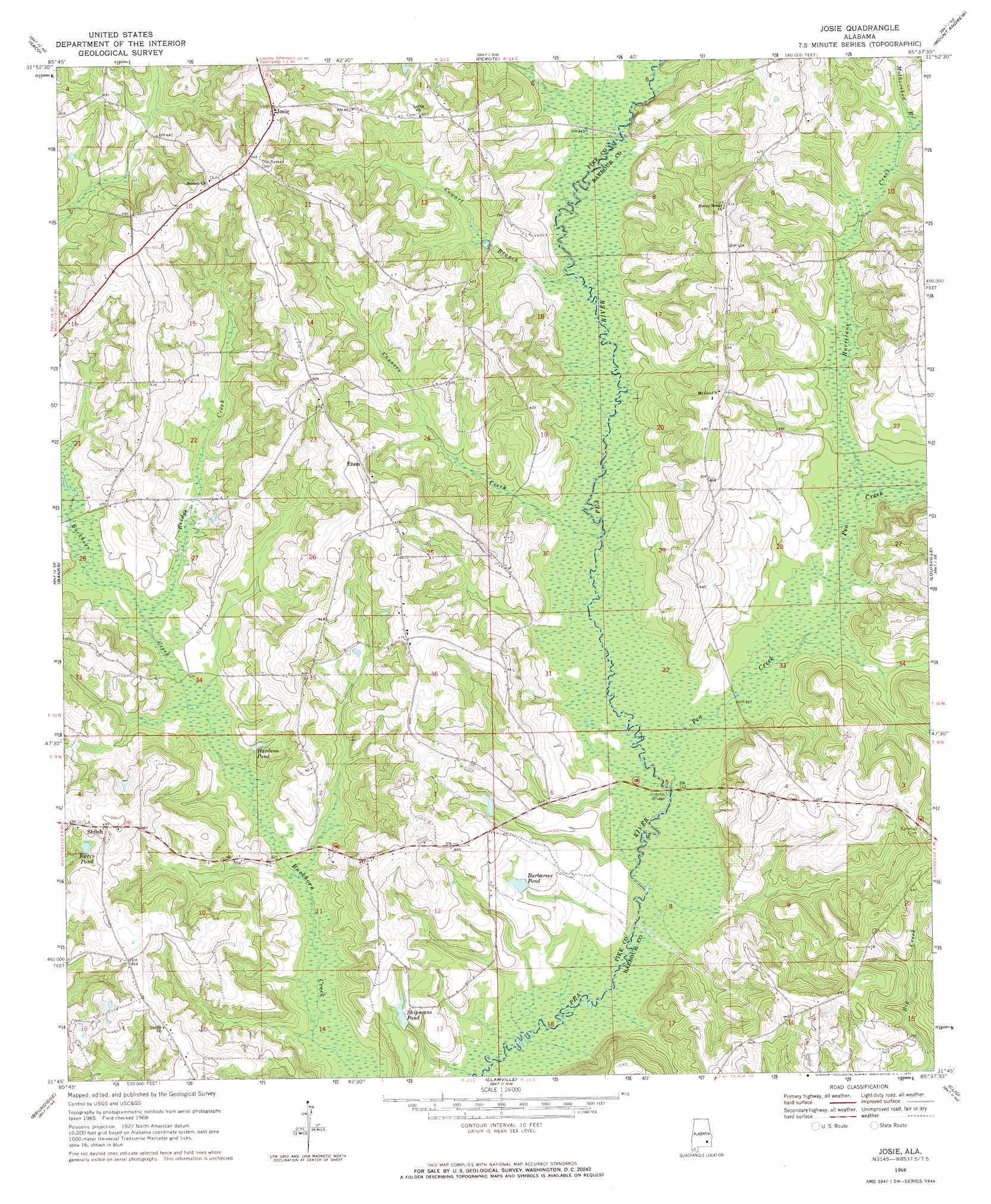
Josie Topo Map Alabama
To zoom in, hover over the map of Josie
USGS Topo Quad 31085g6 - 1:24,000 scale
| Topo Map Name: | Josie |
| USGS Topo Quad ID: | 31085g6 |
| Print Size: | ca. 21 1/4" wide x 27" high |
| Southeast Coordinates: | 31.75° N latitude / 85.625° W longitude |
| Map Center Coordinates: | 31.8125° N latitude / 85.6875° W longitude |
| U.S. State: | AL |
| Filename: | o31085g6.jpg |
| Download Map JPG Image: | Josie topo map 1:24,000 scale |
| Map Type: | Topographic |
| Topo Series: | 7.5´ |
| Map Scale: | 1:24,000 |
| Source of Map Images: | United States Geological Survey (USGS) |
| Alternate Map Versions: |
Josie AL 1968, updated 1971 Download PDF Buy paper map Josie AL 1968, updated 1971 Download PDF Buy paper map Josie AL 2011 Download PDF Buy paper map Josie AL 2014 Download PDF Buy paper map |
1:24,000 Topo Quads surrounding Josie
China Grove |
Almeria |
Aberfoil |
Midway |
Comer |
Needmore |
Saco |
Perote |
Mount Andrew |
Clayton North |
Troy |
Banks |
Josie |
Louisville |
Clayton South |
Brundidge Nw |
Brundidge |
Elamville |
Clio |
Texasville |
Victoria |
Brundidge Se |
Ariton |
Skipperville |
Clopton |
> Back to 31085e1 at 1:100,000 scale
> Back to 31084a1 at 1:250,000 scale
> Back to U.S. Topo Maps home
Josie topo map: Gazetteer
Josie: Airports
Louisville AHP Airport elevation 117m 383′Josie: Bridges
Hobdys Bridge elevation 94m 308′Lawsons Bridge (historical) elevation 101m 331′
Josie: Populated Places
Enon elevation 147m 482′Josie elevation 179m 587′
Shiloh elevation 148m 485′
Josie: Reservoirs
Barbarees Pond elevation 108m 354′Barrs Pond elevation 126m 413′
Hardens Pond elevation 102m 334′
Shipmans Pond elevation 107m 351′
Josie: Streams
Bridge Creek elevation 102m 334′Connors Creek elevation 97m 318′
Cowart Branch elevation 100m 328′
Hurricane Creek elevation 100m 328′
Mothershed Branch elevation 108m 354′
Pea Creek elevation 95m 311′
Sand Creek elevation 112m 367′
Josie digital topo map on disk
Buy this Josie topo map showing relief, roads, GPS coordinates and other geographical features, as a high-resolution digital map file on DVD:
Gulf Coast (LA, MS, AL, FL) & Southwestern Georgia
Buy digital topo maps: Gulf Coast (LA, MS, AL, FL) & Southwestern Georgia
 & Southwestern Georgia map DVD")