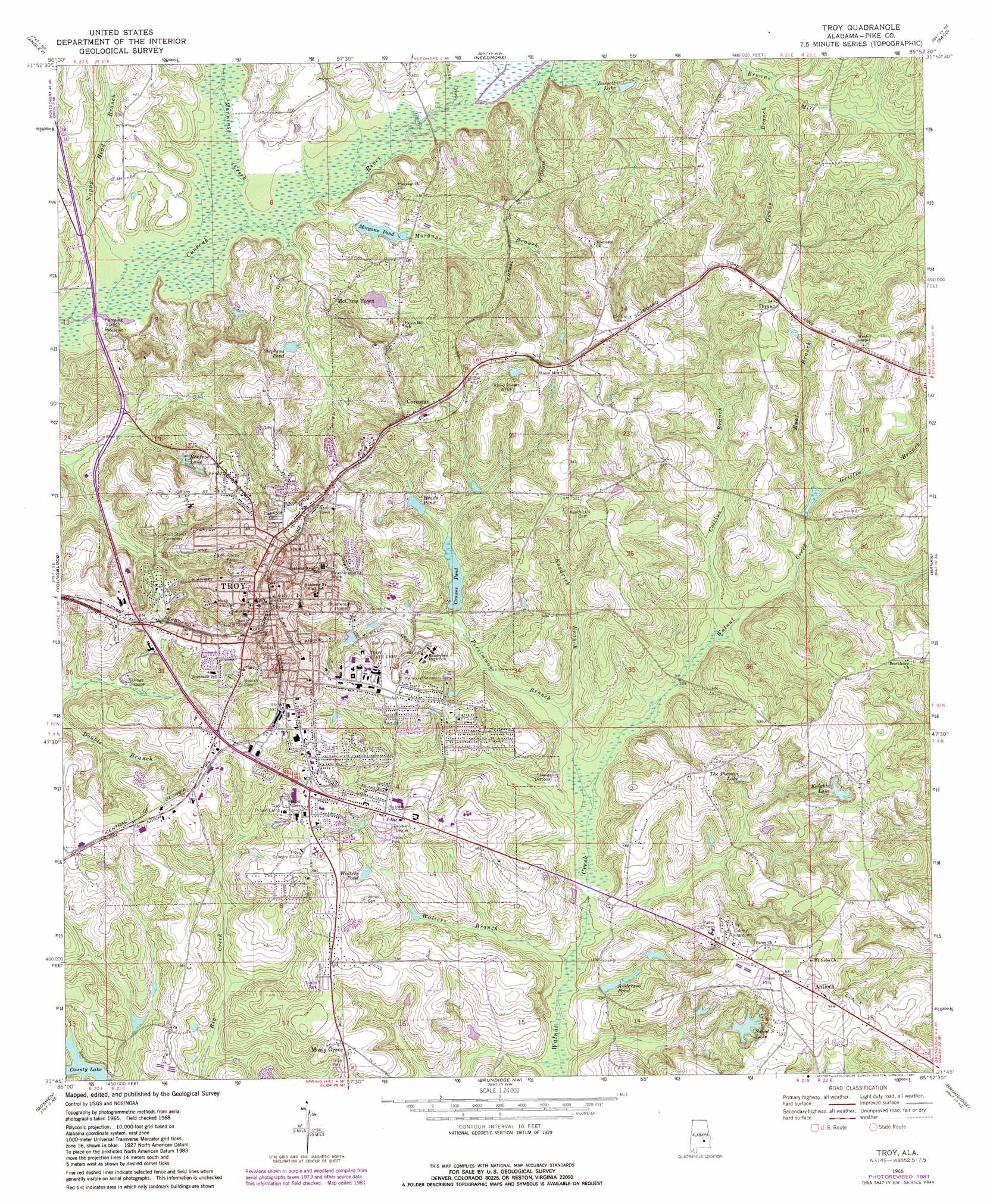
Troy Topo Map Alabama
To zoom in, hover over the map of Troy
USGS Topo Quad 31085g8 - 1:24,000 scale
| Topo Map Name: | Troy |
| USGS Topo Quad ID: | 31085g8 |
| Print Size: | ca. 21 1/4" wide x 27" high |
| Southeast Coordinates: | 31.75° N latitude / 85.875° W longitude |
| Map Center Coordinates: | 31.8125° N latitude / 85.9375° W longitude |
| U.S. State: | AL |
| Filename: | o31085g8.jpg |
| Download Map JPG Image: | Troy topo map 1:24,000 scale |
| Map Type: | Topographic |
| Topo Series: | 7.5´ |
| Map Scale: | 1:24,000 |
| Source of Map Images: | United States Geological Survey (USGS) |
| Alternate Map Versions: |
Troy AL 1968, updated 1971 Download PDF Buy paper map Troy AL 1968, updated 1981 Download PDF Buy paper map Troy AL 2011 Download PDF Buy paper map Troy AL 2014 Download PDF Buy paper map |
1:24,000 Topo Quads surrounding Troy
Ramer |
Pine Level |
China Grove |
Almeria |
Aberfoil |
Grady |
Ansley |
Needmore |
Saco |
Perote |
Petrey |
Youngblood |
Troy |
Banks |
Josie |
Glenwood |
Goshen |
Brundidge Nw |
Brundidge |
Elamville |
Bullock |
Bluff Springs |
Victoria |
Brundidge Se |
Ariton |
> Back to 31085e1 at 1:100,000 scale
> Back to 31084a1 at 1:250,000 scale
> Back to U.S. Topo Maps home
Troy topo map: Gazetteer
Troy: Bridges
Faulk Bridge elevation 108m 354′Orion Bridge elevation 101m 331′
Troy: Dams
Crowes elevation 123m 403′Heads Pond elevation 128m 419′
Morgan Pond elevation 107m 351′
Pike County Lake elevation 117m 383′
Pocosin Pond Dam elevation 134m 439′
S and S Pond Dam elevation 140m 459′
W R Chapman Lake Dam Number 1 elevation 111m 364′
W R Chapman Lake Dam Number 2 elevation 121m 396′
Troy: Lakes
Pike County Lake elevation 117m 383′Sand S Lake elevation 132m 433′
Troy: Parks
College Street Historic District elevation 166m 544′Fountain Drive Park elevation 143m 469′
Memorial Stadium elevation 157m 515′
Murphree Park elevation 152m 498′
Washington Street Park elevation 136m 446′
Troy: Populated Places
Antioch elevation 157m 515′Brantley Mobile Home Park elevation 111m 364′
College Park elevation 166m 544′
Corcoran elevation 164m 538′
Country Club Estates elevation 156m 511′
Dozier Estates elevation 150m 492′
Dozier Trailer Park elevation 153m 501′
Dunn elevation 167m 547′
Edgewood Mobile Home Park elevation 148m 485′
Elmhill Plantation elevation 147m 482′
Forest Acres Mobile Home Park elevation 152m 498′
Forest Circle elevation 150m 492′
Green Oaks elevation 150m 492′
Heritage Ridge elevation 160m 524′
Highland Park elevation 159m 521′
McClure Town elevation 123m 403′
Mossy Grove elevation 146m 479′
Mountainbrook elevation 163m 534′
North Ridge Mobile Home Park elevation 116m 380′
Northdale elevation 162m 531′
Oaks Heights elevation 150m 492′
Pine Forest Estates elevation 148m 485′
Pine Ridge Estates elevation 167m 547′
Pinewood Estates elevation 149m 488′
Pleasant Hill elevation 132m 433′
Ridgewood elevation 136m 446′
Sunset Mountain Mobile Home Park elevation 134m 439′
Trojan Terrace elevation 169m 554′
Troy elevation 165m 541′
Westview elevation 165m 541′
Wilson Trailer Park elevation 149m 488′
Woodland Hills elevation 153m 501′
Troy: Post Offices
Troy Post Office elevation 166m 544′Troy: Reservoirs
Anderson Pond elevation 113m 370′Bassett Lake elevation 110m 360′
Crowes Pond elevation 123m 403′
Heads Pond elevation 128m 419′
Knights Lake elevation 143m 469′
Morgans Pond elevation 106m 347′
Pike Country Public Lake elevation 117m 383′
Renfroe Lake elevation 129m 423′
Stephens Pond elevation 113m 370′
The Pocosinlake elevation 134m 439′
W R Chapman Lake Number One elevation 111m 364′
W R Chapman Lake Number Two elevation 121m 396′
Walters Pond elevation 132m 433′
Troy: Streams
Collins Branch elevation 115m 377′Dunns Branch elevation 107m 351′
Griffin Branch elevation 124m 406′
Indian Creek elevation 101m 331′
Kendrick Branch elevation 114m 374′
Mannings Creek elevation 100m 328′
Moccasin Branch elevation 102m 334′
Morgans Branch elevation 100m 328′
Nappy Head Branch elevation 99m 324′
Persimmon Branch elevation 110m 360′
Ryals Branch elevation 124m 406′
Walters Branch elevation 106m 347′
Troy: Swamps
The Pocosin (historical) elevation 130m 426′Troy digital topo map on disk
Buy this Troy topo map showing relief, roads, GPS coordinates and other geographical features, as a high-resolution digital map file on DVD:
Gulf Coast (LA, MS, AL, FL) & Southwestern Georgia
Buy digital topo maps: Gulf Coast (LA, MS, AL, FL) & Southwestern Georgia
 & Southwestern Georgia map DVD")