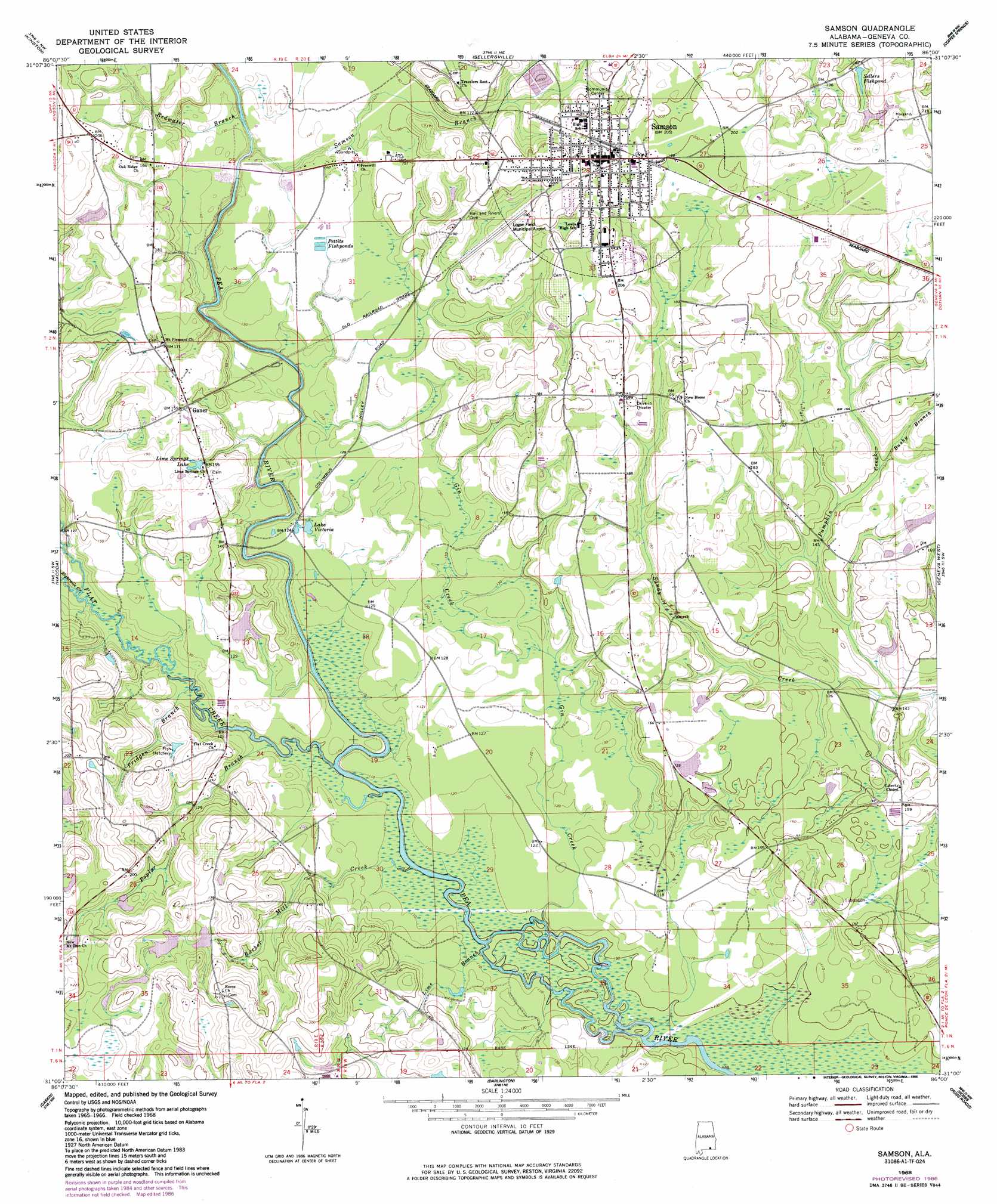
Samson Topo Map Alabama
To zoom in, hover over the map of Samson
USGS Topo Quad 31086a1 - 1:24,000 scale
| Topo Map Name: | Samson |
| USGS Topo Quad ID: | 31086a1 |
| Print Size: | ca. 21 1/4" wide x 27" high |
| Southeast Coordinates: | 31° N latitude / 86° W longitude |
| Map Center Coordinates: | 31.0625° N latitude / 86.0625° W longitude |
| U.S. State: | AL |
| Filename: | o31086a1.jpg |
| Download Map JPG Image: | Samson topo map 1:24,000 scale |
| Map Type: | Topographic |
| Topo Series: | 7.5´ |
| Map Scale: | 1:24,000 |
| Source of Map Images: | United States Geological Survey (USGS) |
| Alternate Map Versions: |
Samson AL 1968, updated 1970 Download PDF Buy paper map Samson AL 1968, updated 1986 Download PDF Buy paper map Samson AL 2011 Download PDF Buy paper map Samson AL 2014 Download PDF Buy paper map |
1:24,000 Topo Quads surrounding Samson
Opp West |
Opp East |
Ino |
Goodman |
Enterprise |
Onycha |
Kinston |
Sellersville |
Coffee Springs |
Bellwood |
Florala |
Hacoda |
Samson |
Geneva West |
Geneva East |
Paxton |
Gaskin |
Darlington |
Hobbs Crossroads |
Izagora |
New Harmony |
Liberty |
Glendale |
Prosperity |
Caryville |
> Back to 31086a1 at 1:100,000 scale
> Back to 31086a1 at 1:250,000 scale
> Back to U.S. Topo Maps home
Samson topo map: Gazetteer
Samson: Airports
Logan Field Municipal Airport (historical) elevation 52m 170′Samson: Bridges
Cooks Ferry Bridge (historical) elevation 26m 85′Hays Ferry Bridge elevation 30m 98′
Samson: Crossings
Barkers Ferry (historical) elevation 31m 101′Samson: Dams
Neal Spears Dam elevation 50m 164′Tom Davison Dam elevation 48m 157′
Samson: Lakes
Lake Victoria elevation 38m 124′Samson: Populated Places
Ganer elevation 49m 160′Samson elevation 62m 203′
Samson: Post Offices
Samson Post Office elevation 62m 203′Samson: Reservoirs
Lime Springs Lake elevation 49m 160′Neal Spears Lake elevation 50m 164′
Pettits Fishponds elevation 40m 131′
Sellers Fishpond elevation 60m 196′
Tom Davison Lake elevation 48m 157′
Samson: Streams
Barker Mill Creek elevation 30m 98′Bushy Branch elevation 45m 147′
Eightmile Creek elevation 33m 108′
Flat Creek elevation 30m 98′
Gin Creek elevation 30m 98′
Lime Branch elevation 30m 98′
Poplar Branch elevation 30m 98′
Pridgen Branch elevation 30m 98′
Pumpkin Creek elevation 34m 111′
Redwater Branch elevation 32m 104′
Samson Branch elevation 32m 104′
Samson digital topo map on disk
Buy this Samson topo map showing relief, roads, GPS coordinates and other geographical features, as a high-resolution digital map file on DVD:
Gulf Coast (LA, MS, AL, FL) & Southwestern Georgia
Buy digital topo maps: Gulf Coast (LA, MS, AL, FL) & Southwestern Georgia
 & Southwestern Georgia map DVD")