Wing Topo Map Alabama
To zoom in, hover over the map of Wing
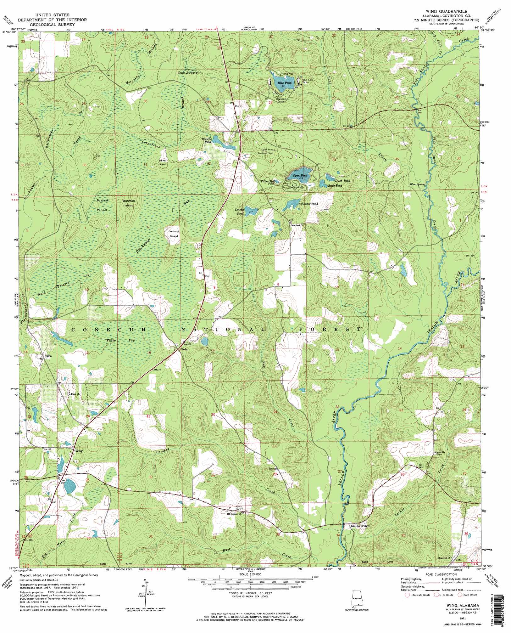
USGS Topo Quad 31086a5 - 1:24,000 scale
| Topo Map Name: | Wing |
| USGS Topo Quad ID: | 31086a5 |
| Print Size: | ca. 21 1/4" wide x 27" high |
| Southeast Coordinates: | 31° N latitude / 86.5° W longitude |
| Map Center Coordinates: | 31.0625° N latitude / 86.5625° W longitude |
| U.S. State: | AL |
| Filename: | o31086a5.jpg |
| Download Map JPG Image: | Wing topo map 1:24,000 scale |
| Map Type: | Topographic |
| Topo Series: | 7.5´ |
| Map Scale: | 1:24,000 |
| Source of Map Images: | United States Geological Survey (USGS) |
| Alternate Map Versions: |
Wing AL 1971, updated 1973 Download PDF Buy paper map Wing AL 1971, updated 1973 Download PDF Buy paper map Wing AL 2011 Download PDF Buy paper map Wing AL 2014 Download PDF Buy paper map |
| FStopo: | US Forest Service topo Wing is available: Download FStopo PDF Download FStopo TIF |
1:24,000 Topo Quads surrounding Wing
Brooklyn |
Loango |
River Falls |
Andalusia |
Opp West |
Damascus |
Dixie |
Carolina |
Libertyville |
Onycha |
Parker Springs |
Bradley |
Wing |
Watkins Bridge |
Florala |
Hurricane Lake |
Blackman |
Oak Grove |
Laurel Hill |
Paxton |
Munson |
Baker |
Crestview North |
Dorcas |
New Harmony |
> Back to 31086a1 at 1:100,000 scale
> Back to 31086a1 at 1:250,000 scale
> Back to U.S. Topo Maps home
Wing topo map: Gazetteer
Wing: Dams
J B Hendley Lake Dam elevation 73m 239′Wing: Islands
Burman Island elevation 74m 242′Dans Island elevation 76m 249′
Lenhart Island elevation 80m 262′
Wing: Lakes
Alligator Pond elevation 68m 223′Blue Lake elevation 65m 213′
Browns Pond elevation 70m 229′
Buck Pond elevation 65m 213′
Ditch Pond elevation 66m 216′
Dowdy Pond elevation 68m 223′
Open Pond elevation 67m 219′
Yellow Hill Pond elevation 76m 249′
Wing: Parks
Blue Pond Recreation Area elevation 65m 213′Open Pond Recreation Area elevation 72m 236′
Wing: Populated Places
Beda elevation 75m 246′Falco elevation 74m 242′
Wing elevation 81m 265′
Wing: Reservoirs
Hendley Lake elevation 73m 239′Wing: Springs
Blue Spring elevation 39m 127′Wing: Streams
Copperhead Branch elevation 65m 213′Crooked Creek elevation 30m 98′
Five Runs Creek elevation 35m 114′
Hog Foot Creek elevation 42m 137′
Larkin Creek elevation 30m 98′
Moccasin Branch elevation 64m 209′
Pond Creek elevation 38m 124′
Rattlesnake Branch elevation 64m 209′
Run Creek elevation 32m 104′
Wing: Swamps
Blackwater Bay elevation 66m 216′Falco Bay elevation 62m 203′
Gum Swamp elevation 71m 232′
Possum Pocket elevation 66m 216′
Wolf Thicket Bay elevation 61m 200′
Wing: Trails
Lake Shore Trail elevation 78m 255′Wing digital topo map on disk
Buy this Wing topo map showing relief, roads, GPS coordinates and other geographical features, as a high-resolution digital map file on DVD:
Gulf Coast (LA, MS, AL, FL) & Southwestern Georgia
Buy digital topo maps: Gulf Coast (LA, MS, AL, FL) & Southwestern Georgia
 & Southwestern Georgia map DVD")