Andalusia Topo Map Alabama
To zoom in, hover over the map of Andalusia
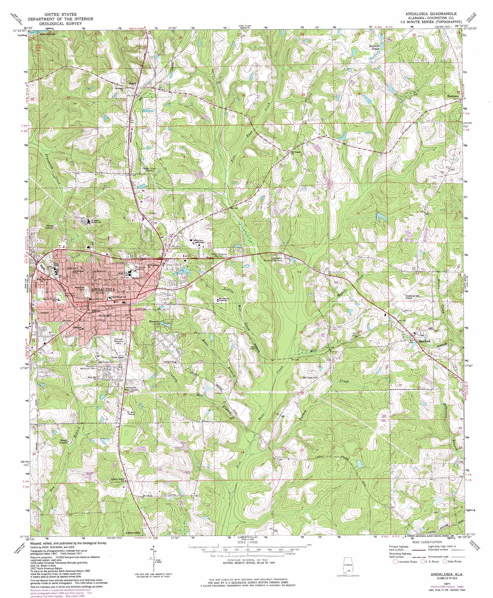
USGS Topo Quad 31086c4 - 1:24,000 scale
| Topo Map Name: | Andalusia |
| USGS Topo Quad ID: | 31086c4 |
| Print Size: | ca. 21 1/4" wide x 27" high |
| Southeast Coordinates: | 31.25° N latitude / 86.375° W longitude |
| Map Center Coordinates: | 31.3125° N latitude / 86.4375° W longitude |
| U.S. State: | AL |
| Filename: | o31086c4.jpg |
| Download Map JPG Image: | Andalusia topo map 1:24,000 scale |
| Map Type: | Topographic |
| Topo Series: | 7.5´ |
| Map Scale: | 1:24,000 |
| Source of Map Images: | United States Geological Survey (USGS) |
| Alternate Map Versions: |
Andalusia AL 1971, updated 1973 Download PDF Buy paper map Andalusia AL 1971, updated 1986 Download PDF Buy paper map Andalusia AL 2011 Download PDF Buy paper map Andalusia AL 2014 Download PDF Buy paper map |
1:24,000 Topo Quads surrounding Andalusia
Mckenzie |
Industry |
Leon |
Brantley |
Bullock |
Brooks |
Red Level |
Gantt |
Dozier |
Danleys Crossroads |
Loango |
River Falls |
Andalusia |
Opp West |
Opp East |
Dixie |
Carolina |
Libertyville |
Onycha |
Kinston |
Bradley |
Wing |
Watkins Bridge |
Florala |
Hacoda |
> Back to 31086a1 at 1:100,000 scale
> Back to 31086a1 at 1:250,000 scale
> Back to U.S. Topo Maps home
Andalusia topo map: Gazetteer
Andalusia: Airports
Andalusia-Opp Airport elevation 96m 314′Andalusia: Parks
Andalusia Commercial Historic District elevation 104m 341′Cooper Park elevation 102m 334′
Johnson Memorial Park elevation 106m 347′
Robinson Memorial Park elevation 93m 305′
Andalusia: Populated Places
Andalusia elevation 106m 347′Heath elevation 110m 360′
Sanford elevation 88m 288′
Andalusia: Post Offices
Andalusia Post Office elevation 104m 341′Andalusia: Reservoirs
Pineview Lake elevation 88m 288′Radford Ponds elevation 106m 347′
Andalusia: Streams
Knox Branch elevation 66m 216′Lindsey Mill Branch elevation 64m 209′
Littles Mill Creek elevation 67m 219′
Mancil Creek elevation 70m 229′
Mill Creek elevation 70m 229′
Turkey Creek elevation 63m 206′
Andalusia digital topo map on disk
Buy this Andalusia topo map showing relief, roads, GPS coordinates and other geographical features, as a high-resolution digital map file on DVD:
Gulf Coast (LA, MS, AL, FL) & Southwestern Georgia
Buy digital topo maps: Gulf Coast (LA, MS, AL, FL) & Southwestern Georgia
 & Southwestern Georgia map DVD")