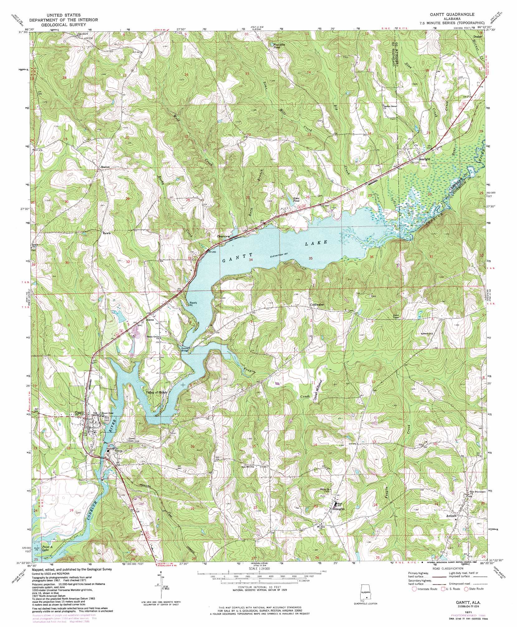
Gantt Topo Map Alabama
To zoom in, hover over the map of Gantt
USGS Topo Quad 31086d4 - 1:24,000 scale
| Topo Map Name: | Gantt |
| USGS Topo Quad ID: | 31086d4 |
| Print Size: | ca. 21 1/4" wide x 27" high |
| Southeast Coordinates: | 31.375° N latitude / 86.375° W longitude |
| Map Center Coordinates: | 31.4375° N latitude / 86.4375° W longitude |
| U.S. State: | AL |
| Filename: | o31086d4.jpg |
| Download Map JPG Image: | Gantt topo map 1:24,000 scale |
| Map Type: | Topographic |
| Topo Series: | 7.5´ |
| Map Scale: | 1:24,000 |
| Source of Map Images: | United States Geological Survey (USGS) |
| Alternate Map Versions: |
Gantt AL 1971, updated 1973 Download PDF Buy paper map Gantt AL 1971, updated 1986 Download PDF Buy paper map Gantt AL 2011 Download PDF Buy paper map Gantt AL 2014 Download PDF Buy paper map |
1:24,000 Topo Quads surrounding Gantt
Georgiana East |
Pigeon Creek |
Moodys Crossroads |
Luverne |
Glenwood |
Mckenzie |
Industry |
Leon |
Brantley |
Bullock |
Brooks |
Red Level |
Gantt |
Dozier |
Danleys Crossroads |
Loango |
River Falls |
Andalusia |
Opp West |
Opp East |
Dixie |
Carolina |
Libertyville |
Onycha |
Kinston |
> Back to 31086a1 at 1:100,000 scale
> Back to 31086a1 at 1:250,000 scale
> Back to U.S. Topo Maps home
Gantt topo map: Gazetteer
Gantt: Bridges
Dunns Bridge elevation 60m 196′Gantt: Capes
Rawls Point elevation 60m 196′Gantt: Dams
Billy Carter Lake Dam elevation 84m 275′Gantt Dam elevation 70m 229′
Roscoe Woorley Lake Dam elevation 111m 364′
Gantt: Populated Places
Antioch elevation 120m 393′Boston elevation 123m 403′
Clearview elevation 77m 252′
Coldwater elevation 105m 344′
Dunns elevation 81m 265′
Gantt elevation 71m 232′
Rawls elevation 120m 393′
Searight elevation 70m 229′
Straughn elevation 114m 374′
Valley of Shiloh elevation 66m 216′
Gantt: Post Offices
Gantt Post Office elevation 69m 226′Gantt: Reservoirs
Franklin Lake elevation 111m 364′Franklin Pond elevation 128m 419′
Gantt Lake elevation 60m 196′
Gantt Millpond elevation 73m 239′
Sims Pond elevation 76m 249′
Gantt: Streams
Bear Creek elevation 60m 196′Big Creek elevation 60m 196′
Burn Branch elevation 66m 216′
Feagin Creek elevation 60m 196′
Rocky Creek elevation 64m 209′
Sims Mill Creek elevation 66m 216′
Sina Creek elevation 63m 206′
Wolf Creek elevation 60m 196′
Gantt digital topo map on disk
Buy this Gantt topo map showing relief, roads, GPS coordinates and other geographical features, as a high-resolution digital map file on DVD:
Gulf Coast (LA, MS, AL, FL) & Southwestern Georgia
Buy digital topo maps: Gulf Coast (LA, MS, AL, FL) & Southwestern Georgia
 & Southwestern Georgia map DVD")