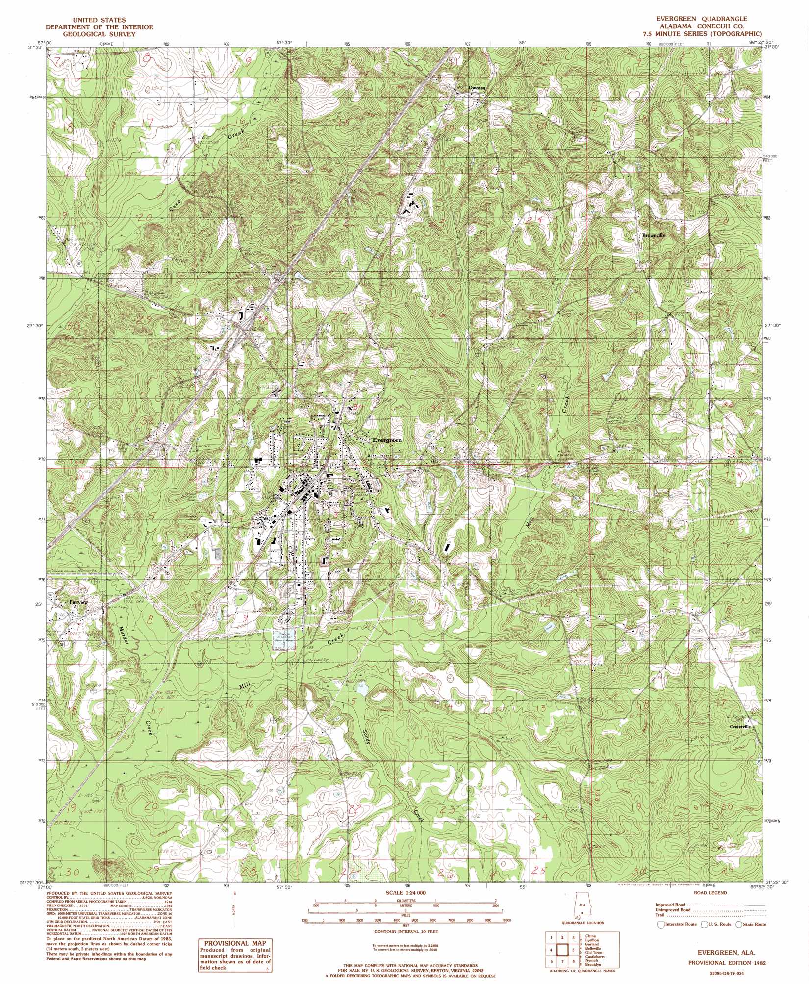
Evergreen Topo Map Alabama
To zoom in, hover over the map of Evergreen
USGS Topo Quad 31086d8 - 1:24,000 scale
| Topo Map Name: | Evergreen |
| USGS Topo Quad ID: | 31086d8 |
| Print Size: | ca. 21 1/4" wide x 27" high |
| Southeast Coordinates: | 31.375° N latitude / 86.875° W longitude |
| Map Center Coordinates: | 31.4375° N latitude / 86.9375° W longitude |
| U.S. State: | AL |
| Filename: | o31086d8.jpg |
| Download Map JPG Image: | Evergreen topo map 1:24,000 scale |
| Map Type: | Topographic |
| Topo Series: | 7.5´ |
| Map Scale: | 1:24,000 |
| Source of Map Images: | United States Geological Survey (USGS) |
| Alternate Map Versions: |
Evergreen AL 1982, updated 1982 Download PDF Buy paper map Evergreen AL 2011 Download PDF Buy paper map Evergreen AL 2014 Download PDF Buy paper map |
1:24,000 Topo Quads surrounding Evergreen
Beatrice |
Skinnerton |
Bethel |
Georgiana West |
Georgiana East |
Burnt Corn |
China |
Lyeffion |
Garland |
Mckenzie |
Repton |
Belleville |
Evergreen |
Old Town |
Brooks |
Range |
Castleberry |
Nymph |
Brooklyn |
Loango |
Wallace |
Brewton North |
Shipps Creek |
Damascus |
Dixie |
> Back to 31086a1 at 1:100,000 scale
> Back to 31086a1 at 1:250,000 scale
> Back to U.S. Topo Maps home
Evergreen topo map: Gazetteer
Evergreen: Crossings
Exit 96 elevation 106m 347′Evergreen: Dams
Evergreen Sewage Lagoon Dam elevation 59m 193′Moody Lake Dam elevation 88m 288′
Morgans Dam elevation 90m 295′
Evergreen: Populated Places
Brownville elevation 108m 354′Centerville elevation 110m 360′
Evergreen elevation 83m 272′
Owassa elevation 119m 390′
Rabb elevation 108m 354′
Evergreen: Post Offices
Evergreen Post Office elevation 90m 295′Evergreen: Reservoirs
Evergreen Sewage Lagoon elevation 59m 193′Lake Shirley elevation 81m 265′
Moody Lake elevation 88m 288′
Morgans Pond elevation 90m 295′
Evergreen: Streams
Mill Creek elevation 54m 177′Sandy Creek elevation 57m 187′
Evergreen digital topo map on disk
Buy this Evergreen topo map showing relief, roads, GPS coordinates and other geographical features, as a high-resolution digital map file on DVD:
Gulf Coast (LA, MS, AL, FL) & Southwestern Georgia
Buy digital topo maps: Gulf Coast (LA, MS, AL, FL) & Southwestern Georgia
 & Southwestern Georgia map DVD")