Bluff Springs Topo Map Alabama
To zoom in, hover over the map of Bluff Springs
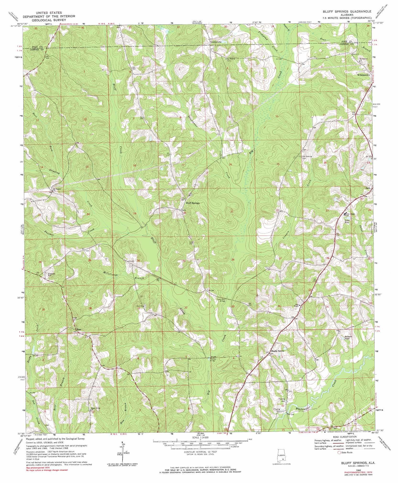
USGS Topo Quad 31086e1 - 1:24,000 scale
| Topo Map Name: | Bluff Springs |
| USGS Topo Quad ID: | 31086e1 |
| Print Size: | ca. 21 1/4" wide x 27" high |
| Southeast Coordinates: | 31.5° N latitude / 86° W longitude |
| Map Center Coordinates: | 31.5625° N latitude / 86.0625° W longitude |
| U.S. State: | AL |
| Filename: | o31086e1.jpg |
| Download Map JPG Image: | Bluff Springs topo map 1:24,000 scale |
| Map Type: | Topographic |
| Topo Series: | 7.5´ |
| Map Scale: | 1:24,000 |
| Source of Map Images: | United States Geological Survey (USGS) |
| Alternate Map Versions: |
Bluff Springs AL 1968, updated 1970 Download PDF Buy paper map Bluff Springs AL 1968, updated 1984 Download PDF Buy paper map Bluff Springs AL 2011 Download PDF Buy paper map Bluff Springs AL 2014 Download PDF Buy paper map |
1:24,000 Topo Quads surrounding Bluff Springs
Fullers Crossroads |
Petrey |
Youngblood |
Troy |
Banks |
Luverne |
Glenwood |
Goshen |
Brundidge Nw |
Brundidge |
Brantley |
Bullock |
Bluff Springs |
Victoria |
Brundidge Se |
Dozier |
Danleys Crossroads |
Elba |
New Brockton |
Enterprise Ne |
Opp West |
Opp East |
Ino |
Goodman |
Enterprise |
> Back to 31086e1 at 1:100,000 scale
> Back to 31086a1 at 1:250,000 scale
> Back to U.S. Topo Maps home
Bluff Springs topo map: Gazetteer
Bluff Springs: Bridges
Lewis Mill Bridge elevation 67m 219′Thames Bridge elevation 65m 213′
Bluff Springs: Populated Places
Bluff Springs elevation 117m 383′Jack elevation 119m 390′
Shady Grove elevation 102m 334′
Zoar elevation 136m 446′
Bluff Springs: Post Offices
Jack Post Office elevation 120m 393′Bluff Springs: Reservoirs
Jackson Pond elevation 88m 288′Lake Zion elevation 108m 354′
Bluff Springs: Streams
Bluff Creek elevation 67m 219′Cowpen Creek elevation 70m 229′
Dugans Branch elevation 79m 259′
East Fork Stinking Creek elevation 87m 285′
Fishpond Creek elevation 79m 259′
McCollough Branch elevation 73m 239′
Panther Creek elevation 80m 262′
Pridgeon Branch elevation 65m 213′
Reedy Creek elevation 79m 259′
Stinking Creek elevation 75m 246′
Sweetwater Creek elevation 74m 242′
White Springs Branch elevation 78m 255′
Yellow Bank Creek elevation 64m 209′
Bluff Springs: Summits
Coston Hill elevation 141m 462′Bluff Springs digital topo map on disk
Buy this Bluff Springs topo map showing relief, roads, GPS coordinates and other geographical features, as a high-resolution digital map file on DVD:
Gulf Coast (LA, MS, AL, FL) & Southwestern Georgia
Buy digital topo maps: Gulf Coast (LA, MS, AL, FL) & Southwestern Georgia
 & Southwestern Georgia map DVD")