Luverne Topo Map Alabama
To zoom in, hover over the map of Luverne
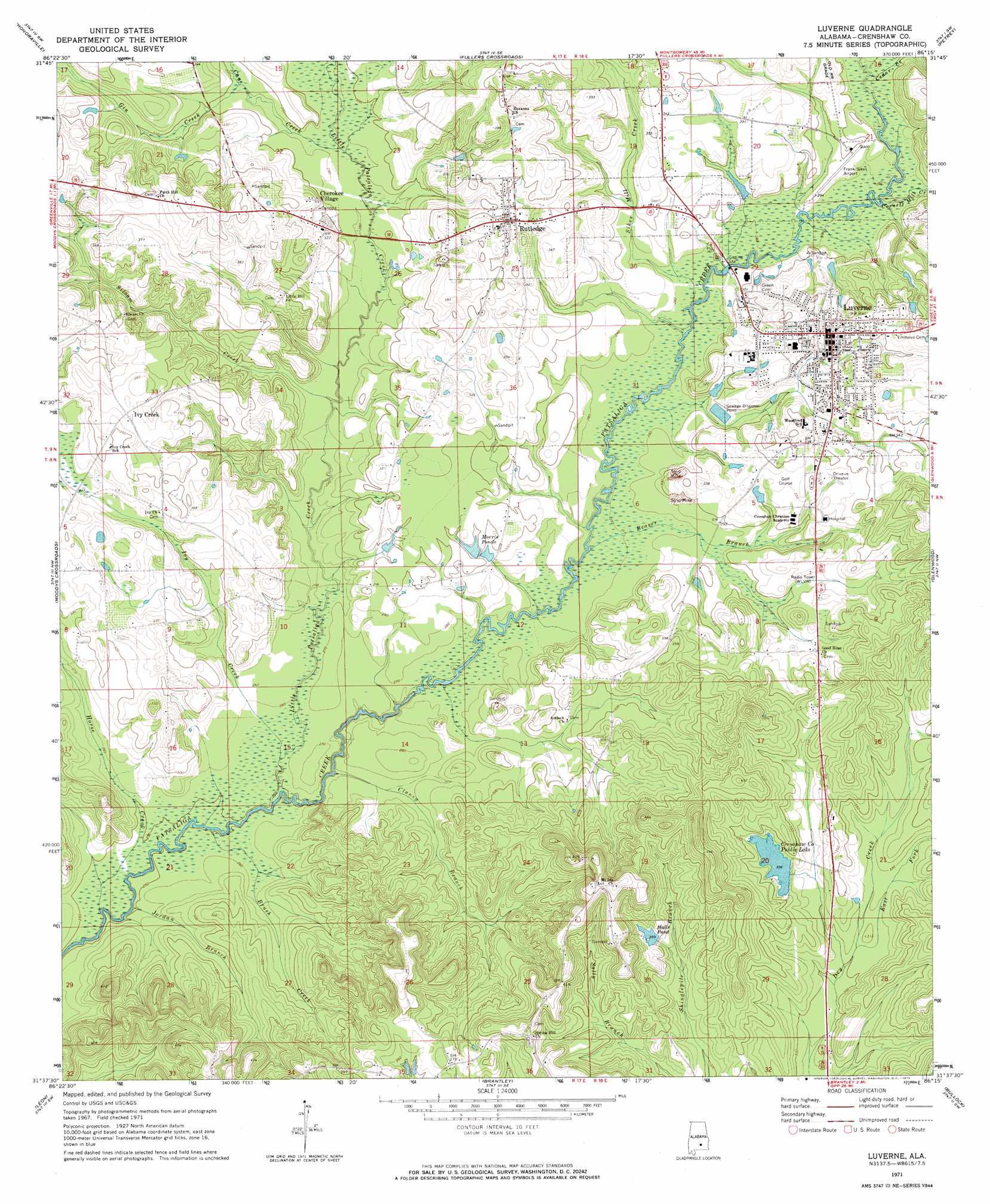
USGS Topo Quad 31086f3 - 1:24,000 scale
| Topo Map Name: | Luverne |
| USGS Topo Quad ID: | 31086f3 |
| Print Size: | ca. 21 1/4" wide x 27" high |
| Southeast Coordinates: | 31.625° N latitude / 86.25° W longitude |
| Map Center Coordinates: | 31.6875° N latitude / 86.3125° W longitude |
| U.S. State: | AL |
| Filename: | o31086f3.jpg |
| Download Map JPG Image: | Luverne topo map 1:24,000 scale |
| Map Type: | Topographic |
| Topo Series: | 7.5´ |
| Map Scale: | 1:24,000 |
| Source of Map Images: | United States Geological Survey (USGS) |
| Alternate Map Versions: |
Luverne AL 1971, updated 1973 Download PDF Buy paper map Luverne AL 2011 Download PDF Buy paper map Luverne AL 2014 Download PDF Buy paper map |
1:24,000 Topo Quads surrounding Luverne
Fort Deposit |
Danielsville |
Lapine |
Grady |
Ansley |
Greenville East |
Honoraville |
Fullers Crossroads |
Petrey |
Youngblood |
Pigeon Creek |
Moodys Crossroads |
Luverne |
Glenwood |
Goshen |
Industry |
Leon |
Brantley |
Bullock |
Bluff Springs |
Red Level |
Gantt |
Dozier |
Danleys Crossroads |
Elba |
> Back to 31086e1 at 1:100,000 scale
> Back to 31086a1 at 1:250,000 scale
> Back to U.S. Topo Maps home
Luverne topo map: Gazetteer
Luverne: Airports
Frank Sikes Airport elevation 89m 291′Luverne: Dams
Crenshaw County Lake Dam elevation 102m 334′E S Stewart Dam elevation 98m 321′
Luverne: Parks
Douglas Park elevation 101m 331′Luverne Park elevation 105m 344′
Luverne: Populated Places
Cherokee Village elevation 98m 321′Ivy Creek elevation 114m 374′
Luverne elevation 108m 354′
Rutledge elevation 105m 344′
Luverne: Reservoirs
Crenshaw County Public Lake elevation 102m 334′E S Stewart Pond elevation 98m 321′
Halls Pond elevation 105m 344′
Morris Pond elevation 90m 295′
Luverne: Streams
Beaver Branch elevation 79m 259′Brush Creek elevation 76m 249′
Cane Creek elevation 86m 282′
Cedar Creek elevation 85m 278′
Clansy Branch elevation 76m 249′
Cornett Mill Creek elevation 85m 278′
East Fork Dry Creek elevation 92m 301′
Gin Creek elevation 89m 291′
Horse Creek elevation 73m 239′
Ivy Creek elevation 76m 249′
Jordan Branch elevation 73m 239′
Little Patsaliga Creek elevation 74m 242′
Sikes Mill Creek elevation 82m 269′
Siloam Creek elevation 82m 269′
Wise Branch elevation 85m 278′
Luverne digital topo map on disk
Buy this Luverne topo map showing relief, roads, GPS coordinates and other geographical features, as a high-resolution digital map file on DVD:
Gulf Coast (LA, MS, AL, FL) & Southwestern Georgia
Buy digital topo maps: Gulf Coast (LA, MS, AL, FL) & Southwestern Georgia
 & Southwestern Georgia map DVD")