Pigeon Creek Topo Map Alabama
To zoom in, hover over the map of Pigeon Creek
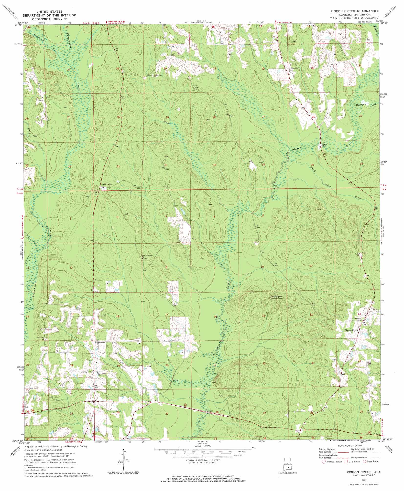
USGS Topo Quad 31086f5 - 1:24,000 scale
| Topo Map Name: | Pigeon Creek |
| USGS Topo Quad ID: | 31086f5 |
| Print Size: | ca. 21 1/4" wide x 27" high |
| Southeast Coordinates: | 31.625° N latitude / 86.5° W longitude |
| Map Center Coordinates: | 31.6875° N latitude / 86.5625° W longitude |
| U.S. State: | AL |
| Filename: | o31086f5.jpg |
| Download Map JPG Image: | Pigeon Creek topo map 1:24,000 scale |
| Map Type: | Topographic |
| Topo Series: | 7.5´ |
| Map Scale: | 1:24,000 |
| Source of Map Images: | United States Geological Survey (USGS) |
| Alternate Map Versions: |
Pigeon Creek AL 1971, updated 1973 Download PDF Buy paper map Pigeon Creek AL 2011 Download PDF Buy paper map Pigeon Creek AL 2014 Download PDF Buy paper map |
1:24,000 Topo Quads surrounding Pigeon Creek
Ridgeville |
Fort Dale |
Fort Deposit |
Danielsville |
Lapine |
Forest Home |
Greenville West |
Greenville East |
Honoraville |
Fullers Crossroads |
Georgiana West |
Georgiana East |
Pigeon Creek |
Moodys Crossroads |
Luverne |
Garland |
Mckenzie |
Industry |
Leon |
Brantley |
Old Town |
Brooks |
Red Level |
Gantt |
Dozier |
> Back to 31086e1 at 1:100,000 scale
> Back to 31086a1 at 1:250,000 scale
> Back to U.S. Topo Maps home
Pigeon Creek topo map: Gazetteer
Pigeon Creek: Bridges
Mercers Bridge (historical) elevation 81m 265′Pigeon Creek: Populated Places
Halso Mill elevation 84m 275′Pigeon Creek elevation 120m 393′
Sardis elevation 126m 413′
Pigeon Creek: Streams
Deep Step Creek elevation 83m 272′Hard Labor Creek elevation 76m 249′
Harrigan Creek elevation 80m 262′
Hawkins Creek elevation 89m 291′
Pigeon Creek digital topo map on disk
Buy this Pigeon Creek topo map showing relief, roads, GPS coordinates and other geographical features, as a high-resolution digital map file on DVD:
Gulf Coast (LA, MS, AL, FL) & Southwestern Georgia
Buy digital topo maps: Gulf Coast (LA, MS, AL, FL) & Southwestern Georgia
 & Southwestern Georgia map DVD")