Petrey Topo Map Alabama
To zoom in, hover over the map of Petrey
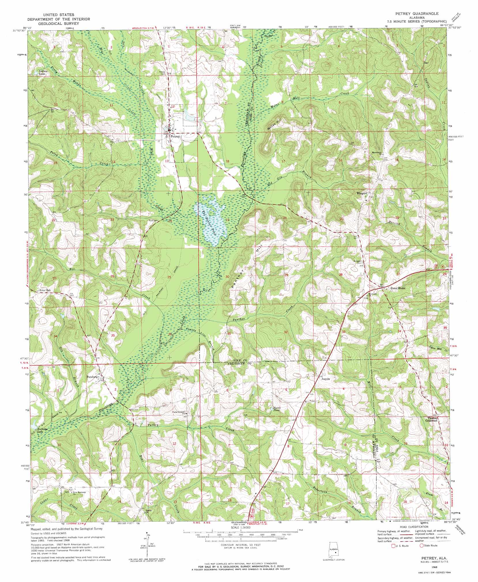
USGS Topo Quad 31086g2 - 1:24,000 scale
| Topo Map Name: | Petrey |
| USGS Topo Quad ID: | 31086g2 |
| Print Size: | ca. 21 1/4" wide x 27" high |
| Southeast Coordinates: | 31.75° N latitude / 86.125° W longitude |
| Map Center Coordinates: | 31.8125° N latitude / 86.1875° W longitude |
| U.S. State: | AL |
| Filename: | o31086g2.jpg |
| Download Map JPG Image: | Petrey topo map 1:24,000 scale |
| Map Type: | Topographic |
| Topo Series: | 7.5´ |
| Map Scale: | 1:24,000 |
| Source of Map Images: | United States Geological Survey (USGS) |
| Alternate Map Versions: |
Petrey AL 1968, updated 1971 Download PDF Buy paper map Petrey AL 2011 Download PDF Buy paper map Petrey AL 2014 Download PDF Buy paper map |
1:24,000 Topo Quads surrounding Petrey
Sandy Ridge |
Sellers |
Ramer |
Pine Level |
China Grove |
Danielsville |
Lapine |
Grady |
Ansley |
Needmore |
Honoraville |
Fullers Crossroads |
Petrey |
Youngblood |
Troy |
Moodys Crossroads |
Luverne |
Glenwood |
Goshen |
Brundidge Nw |
Leon |
Brantley |
Bullock |
Bluff Springs |
Victoria |
> Back to 31086e1 at 1:100,000 scale
> Back to 31086a1 at 1:250,000 scale
> Back to U.S. Topo Maps home
Petrey topo map: Gazetteer
Petrey: Bridges
Dyers Bridge (historical) elevation 98m 321′Wingard Bridge elevation 95m 311′
Petrey: Lakes
The Beaver Pond elevation 95m 311′Petrey: Populated Places
Joquin elevation 146m 479′Live Oak elevation 158m 518′
Patsburg elevation 104m 341′
Petrey elevation 111m 364′
Thomas Crossroad elevation 130m 426′
Wingard elevation 157m 515′
Petrey: Post Offices
Blue Creek Post Office (historical) elevation 148m 485′Patsburg Post Office (historical) elevation 103m 337′
Petrey: Reservoirs
Byrds Pond elevation 128m 419′Indian Lake elevation 117m 383′
Rutledge Lake elevation 92m 301′
Petrey: Streams
Bear Creek elevation 91m 298′Bee Creek elevation 91m 298′
Blue Creek elevation 93m 305′
County Line Branch elevation 91m 298′
Dry Creek elevation 99m 324′
Gin Branch elevation 88m 288′
Motes Mill Creek elevation 96m 314′
Old Gin Branch elevation 95m 311′
Olustee Creek elevation 101m 331′
Panther Creek elevation 91m 298′
Piney Woods Creek elevation 97m 318′
Poley Creek elevation 97m 318′
Turkey Creek elevation 88m 288′
Petrey: Summits
Motes Hill elevation 156m 511′Panther Hill elevation 153m 501′
Petrey digital topo map on disk
Buy this Petrey topo map showing relief, roads, GPS coordinates and other geographical features, as a high-resolution digital map file on DVD:
Gulf Coast (LA, MS, AL, FL) & Southwestern Georgia
Buy digital topo maps: Gulf Coast (LA, MS, AL, FL) & Southwestern Georgia
 & Southwestern Georgia map DVD")