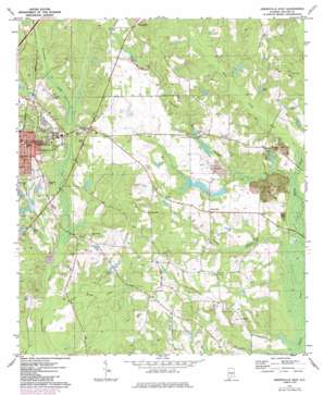
Greenville East Topo Map Alabama
To zoom in, hover over the map of Greenville East
USGS Topo Quad 31086g5 - 1:24,000 scale
| Topo Map Name: | Greenville East |
| USGS Topo Quad ID: | 31086g5 |
| Print Size: | ca. 21 1/4" wide x 27" high |
| Southeast Coordinates: | 31.75° N latitude / 86.5° W longitude |
| Map Center Coordinates: | 31.8125° N latitude / 86.5625° W longitude |
| U.S. State: | AL |
| Filename: | o31086g5.jpg |
| Download Map JPG Image: | Greenville East topo map 1:24,000 scale |
| Map Type: | Topographic |
| Topo Series: | 7.5´ |
| Map Scale: | 1:24,000 |
| Source of Map Images: | United States Geological Survey (USGS) |
| Alternate Map Versions: |
Greenville East AL 1971, updated 1973 Download PDF Buy paper map Greenville East AL 1971, updated 1986 Download PDF Buy paper map Greenville East AL 2011 Download PDF Buy paper map Greenville East AL 2014 Download PDF Buy paper map |
1:24,000 Topo Quads surrounding Greenville East
> Back to 31086e1 at 1:100,000 scale
> Back to 31086a1 at 1:250,000 scale
> Back to U.S. Topo Maps home
Greenville East topo map: Gazetteer
Greenville East: Airports
Greenville Municipal Airport elevation 135m 442′Greenville East: Dams
F H Morgan Lake Dam elevation 112m 367′Greenville Sewage Lagoon Dam elevation 101m 331′
Lake Greenville Dam elevation 113m 370′
Lake Tanner Dam elevation 102m 334′
Sportsmen Club Lake Dam elevation 132m 433′
Stirling Hamilton Lake Dam elevation 117m 383′
Greenville East: Lakes
Luckie Pond elevation 117m 383′Pyror Pond elevation 105m 344′
Greenville East: Parks
Beeland Park elevation 115m 377′Commerce Street Residential Historic District elevation 135m 442′
Confederate Park elevation 136m 446′
Day Memorial Park elevation 113m 370′
East Commerce Street Historic District elevation 135m 442′
Garfield Street Park elevation 128m 419′
Post Office Historic District elevation 135m 442′
South Greenville Historic District elevation 130m 426′
Greenville East: Populated Places
Glasgow elevation 115m 377′Greenville elevation 134m 439′
Mashville elevation 117m 383′
Spring Hill elevation 148m 485′
Greenville East: Post Offices
Greenville Post Office elevation 136m 446′Greenville East: Reservoirs
Boucher Lake elevation 106m 347′F H Morgan Lake elevation 112m 367′
Greenville Sewage Lagoon elevation 101m 331′
Jones Lake elevation 104m 341′
Lake Greenville elevation 112m 367′
Lake Tanner elevation 102m 334′
Newton Pond elevation 108m 354′
Sportsmen Club Lake elevation 132m 433′
Stirling Hamilton Lake elevation 117m 383′
Williams Pond elevation 112m 367′
Greenville East: Streams
Fourmile Mill Branch elevation 91m 298′Halls Creek elevation 89m 291′
Hatchee Branch elevation 88m 288′
Nannie Branch elevation 85m 278′
Ninemile Branch elevation 88m 288′
Piney Woods Creek elevation 92m 301′
Tanyard Branch elevation 101m 331′
Greenville East digital topo map on disk
Buy this Greenville East topo map showing relief, roads, GPS coordinates and other geographical features, as a high-resolution digital map file on DVD:
Gulf Coast (LA, MS, AL, FL) & Southwestern Georgia
Buy digital topo maps: Gulf Coast (LA, MS, AL, FL) & Southwestern Georgia


