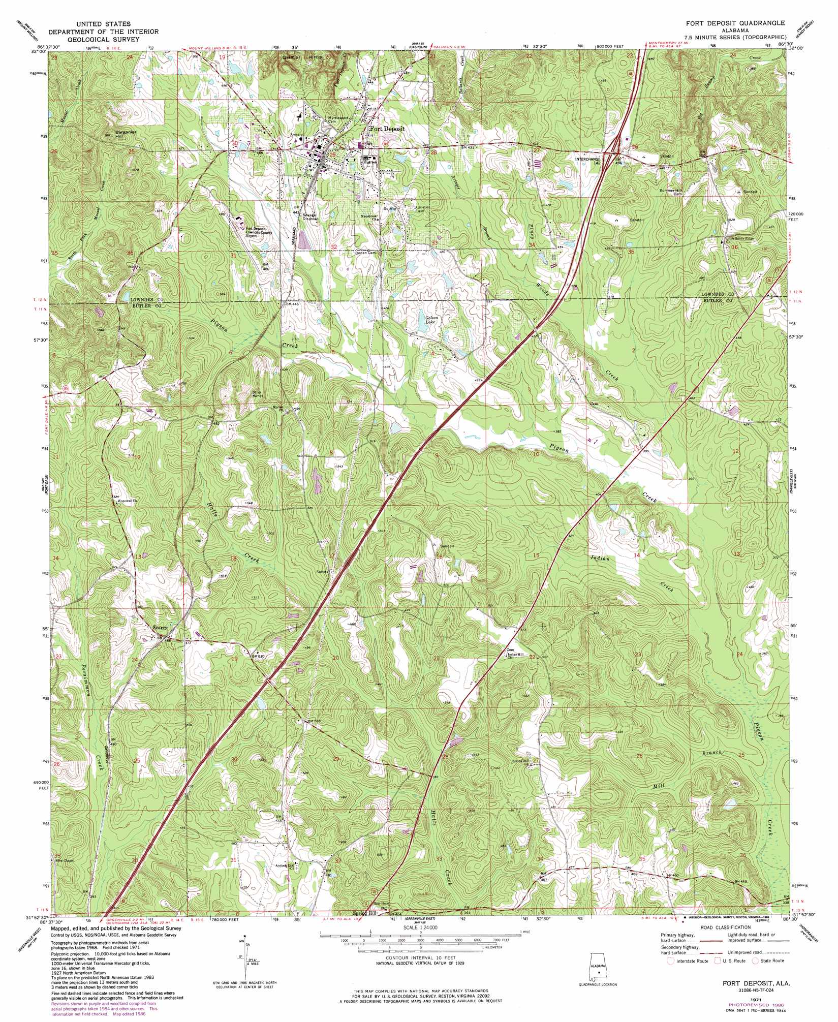
Fort Deposit Topo Map Alabama
To zoom in, hover over the map of Fort Deposit
USGS Topo Quad 31086h5 - 1:24,000 scale
| Topo Map Name: | Fort Deposit |
| USGS Topo Quad ID: | 31086h5 |
| Print Size: | ca. 21 1/4" wide x 27" high |
| Southeast Coordinates: | 31.875° N latitude / 86.5° W longitude |
| Map Center Coordinates: | 31.9375° N latitude / 86.5625° W longitude |
| U.S. State: | AL |
| Filename: | o31086h5.jpg |
| Download Map JPG Image: | Fort Deposit topo map 1:24,000 scale |
| Map Type: | Topographic |
| Topo Series: | 7.5´ |
| Map Scale: | 1:24,000 |
| Source of Map Images: | United States Geological Survey (USGS) |
| Alternate Map Versions: |
Fort Deposit AL 1971, updated 1973 Download PDF Buy paper map Fort Deposit AL 1971, updated 1986 Download PDF Buy paper map Fort Deposit AL 2011 Download PDF Buy paper map Fort Deposit AL 2014 Download PDF Buy paper map |
1:24,000 Topo Quads surrounding Fort Deposit
Collirene |
Gordonsville |
Hayneville |
Letohatchee |
Snowdoun |
Braggs |
Mount Willing |
Calhoun |
Sandy Ridge |
Sellers |
Ridgeville |
Fort Dale |
Fort Deposit |
Danielsville |
Lapine |
Forest Home |
Greenville West |
Greenville East |
Honoraville |
Fullers Crossroads |
Georgiana West |
Georgiana East |
Pigeon Creek |
Moodys Crossroads |
Luverne |
> Back to 31086e1 at 1:100,000 scale
> Back to 31086a1 at 1:250,000 scale
> Back to U.S. Topo Maps home
Fort Deposit topo map: Gazetteer
Fort Deposit: Airports
Fort Deposit-Lowndes County Airport elevation 142m 465′Fort Deposit: Crossings
Interchange 142 elevation 136m 446′Fort Deposit: Dams
Golson Pond Dam elevation 130m 426′Fort Deposit: Populated Places
Fort Deposit elevation 142m 465′Searcy elevation 143m 469′
Fort Deposit: Post Offices
Fort Deposit Post Office elevation 146m 479′Fort Deposit: Reservoirs
Golson Lake elevation 130m 426′Fort Deposit: Streams
Avinger Branch elevation 118m 387′Indian Creek elevation 105m 344′
Mill Branch elevation 103m 337′
Piney Woods Creek elevation 108m 354′
Fort Deposit: Summits
Barganier Hill elevation 178m 583′Fort Deposit digital topo map on disk
Buy this Fort Deposit topo map showing relief, roads, GPS coordinates and other geographical features, as a high-resolution digital map file on DVD:
Gulf Coast (LA, MS, AL, FL) & Southwestern Georgia
Buy digital topo maps: Gulf Coast (LA, MS, AL, FL) & Southwestern Georgia
 & Southwestern Georgia map DVD")