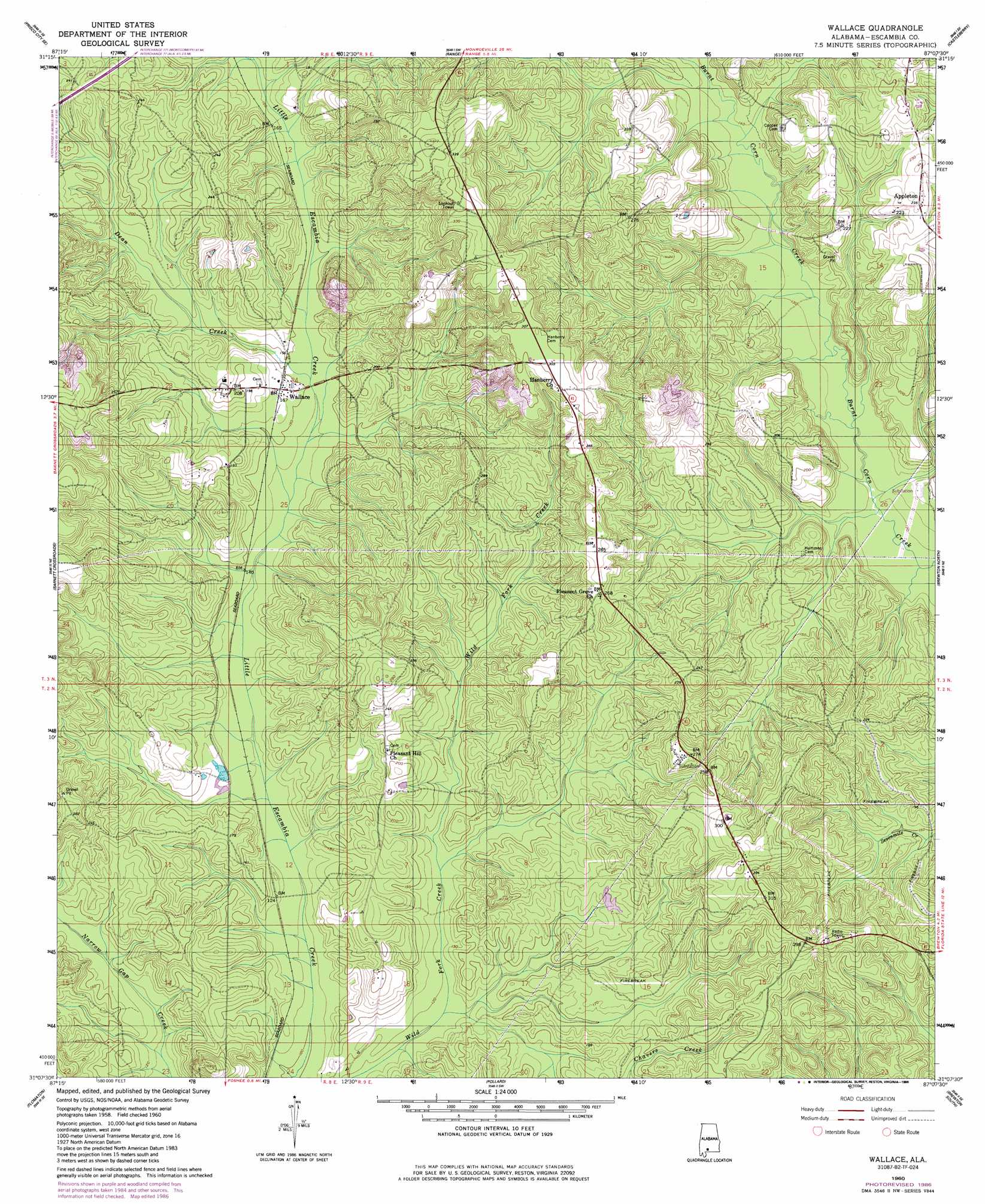
Wallace Topo Map Alabama
To zoom in, hover over the map of Wallace
USGS Topo Quad 31087b2 - 1:24,000 scale
| Topo Map Name: | Wallace |
| USGS Topo Quad ID: | 31087b2 |
| Print Size: | ca. 21 1/4" wide x 27" high |
| Southeast Coordinates: | 31.125° N latitude / 87.125° W longitude |
| Map Center Coordinates: | 31.1875° N latitude / 87.1875° W longitude |
| U.S. State: | AL |
| Filename: | o31087b2.jpg |
| Download Map JPG Image: | Wallace topo map 1:24,000 scale |
| Map Type: | Topographic |
| Topo Series: | 7.5´ |
| Map Scale: | 1:24,000 |
| Source of Map Images: | United States Geological Survey (USGS) |
| Alternate Map Versions: |
Wallace AL 1960, updated 1961 Download PDF Buy paper map Wallace AL 1960, updated 1977 Download PDF Buy paper map Wallace AL 1960, updated 1986 Download PDF Buy paper map Wallace AL 2011 Download PDF Buy paper map Wallace AL 2014 Download PDF Buy paper map |
1:24,000 Topo Quads surrounding Wallace
Frisco City |
Excel |
Repton |
Belleville |
Evergreen |
Uriah East |
Frisco City Se |
Range |
Castleberry |
Nymph |
Huxford |
Barnett Crossroads |
Wallace |
Brewton North |
Shipps Creek |
Atmore |
Flomaton |
Pollard |
Brewton South |
Roberts |
Bratt |
Century |
Jay |
Fidelis |
Mclellan |
> Back to 31087a1 at 1:100,000 scale
> Back to 31086a1 at 1:250,000 scale
> Back to U.S. Topo Maps home
Wallace topo map: Gazetteer
Wallace: Oilfields
Appleton Oil Field elevation 64m 209′Hanberry Church Oil Field elevation 55m 180′
South Burnt Corn Creek Oil Field elevation 64m 209′
Wallace Oil Field elevation 59m 193′
Wallace: Populated Places
Wallace elevation 50m 164′Wallace: Post Offices
Old Town Post Office (historical) elevation 53m 173′Wallace: Streams
Dean Creek elevation 43m 141′Wallace digital topo map on disk
Buy this Wallace topo map showing relief, roads, GPS coordinates and other geographical features, as a high-resolution digital map file on DVD:
Gulf Coast (LA, MS, AL, FL) & Southwestern Georgia
Buy digital topo maps: Gulf Coast (LA, MS, AL, FL) & Southwestern Georgia
 & Southwestern Georgia map DVD")