Gin House Island Topo Map Alabama
To zoom in, hover over the map of Gin House Island
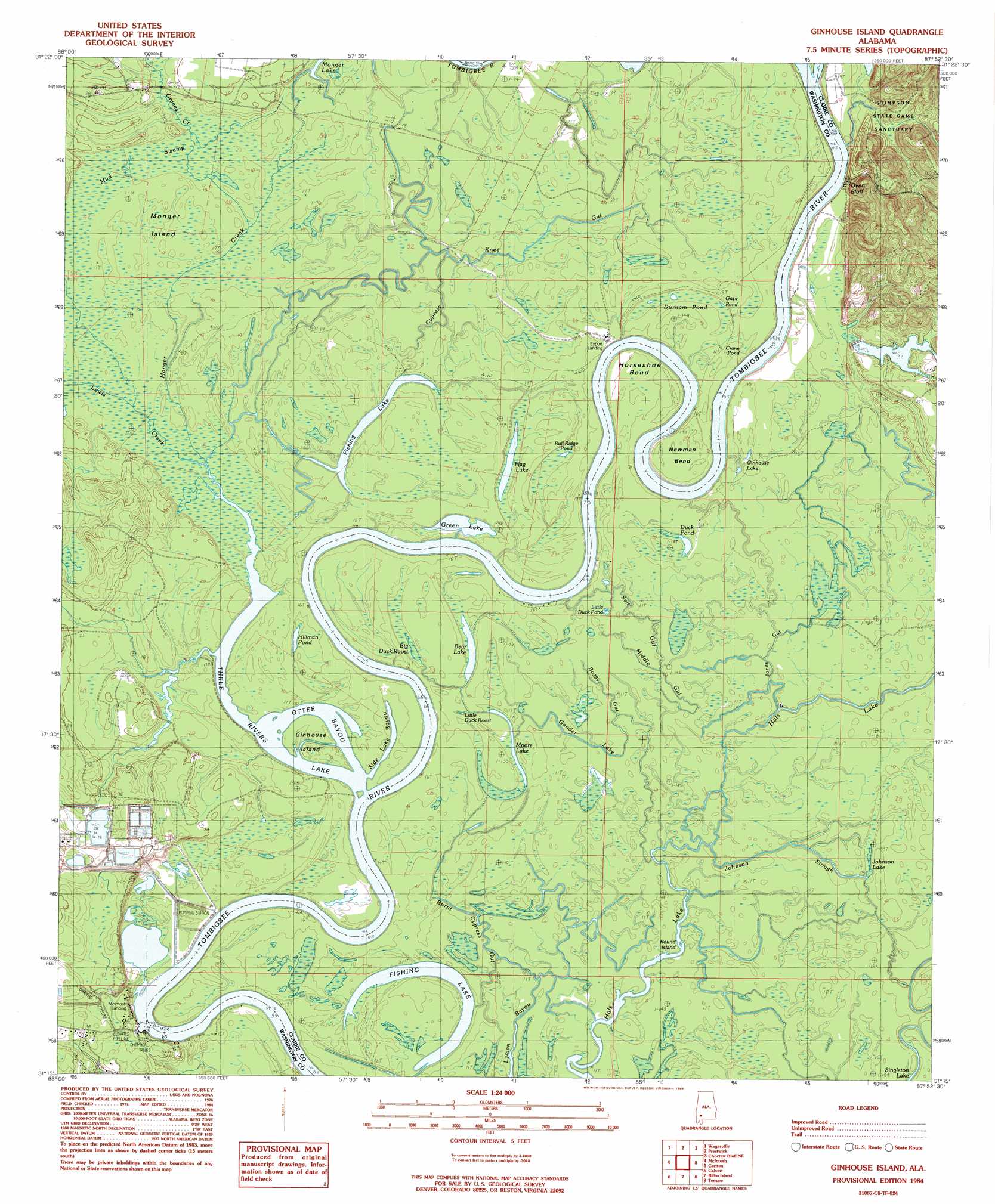
USGS Topo Quad 31087c8 - 1:24,000 scale
| Topo Map Name: | Gin House Island |
| USGS Topo Quad ID: | 31087c8 |
| Print Size: | ca. 21 1/4" wide x 27" high |
| Southeast Coordinates: | 31.25° N latitude / 87.875° W longitude |
| Map Center Coordinates: | 31.3125° N latitude / 87.9375° W longitude |
| U.S. State: | AL |
| Filename: | o31087c8.jpg |
| Download Map JPG Image: | Gin House Island topo map 1:24,000 scale |
| Map Type: | Topographic |
| Topo Series: | 7.5´ |
| Map Scale: | 1:24,000 |
| Source of Map Images: | United States Geological Survey (USGS) |
| Alternate Map Versions: |
Ginhouse Island AL 1984, updated 1984 Download PDF Buy paper map Ginhouse Island AL 2011 Download PDF Buy paper map Ginhouse Island AL 2014 Download PDF Buy paper map |
1:24,000 Topo Quads surrounding Gin House Island
Bigbee |
Saint Stephens |
Jackson |
Walker Springs |
Suggsville |
Rutan |
Wagarville |
Prestwick |
Choctaw Bluff |
Gainestown |
Seaboard |
Mcintosh |
Gin House Island |
Carlton |
Chrysler |
Sims Chapel |
Calvert |
Bilbo Island |
Tensaw |
Blacksher |
Citronelle East |
Mount Vernon |
Stiggins Lake |
Vaughn |
Perdido |
> Back to 31087a1 at 1:100,000 scale
> Back to 31086a1 at 1:250,000 scale
> Back to U.S. Topo Maps home
Gin House Island topo map: Gazetteer
Gin House Island: Bars
Days Bar elevation 1m 3′Gin House Island: Bends
Horseshoe Bend elevation 5m 16′Newman Bend elevation 4m 13′
Gin House Island: Cliffs
McIntosh Bluff elevation 6m 19′Oven Bluff elevation 32m 104′
Gin House Island: Crossings
Holders Ferry (historical) elevation 5m 16′Gin House Island: Dams
D R Dunlap Estate Dam elevation 6m 19′Gin House Island: Guts
Boggy Gut elevation 2m 6′Burnt Cypress Gut elevation 2m 6′
Cypress Knee Gut elevation 2m 6′
Gander Lake elevation 2m 6′
Johnson Lake elevation 2m 6′
Johnson Slough elevation 3m 9′
Jones Gut elevation 2m 6′
Lyman Bayou elevation 2m 6′
Middle Gut elevation 2m 6′
Otter Bayou elevation 1m 3′
Salt Gut elevation 2m 6′
Side Lake Bayou elevation 2m 6′
Gin House Island: Islands
Ginhouse Island elevation 3m 9′Monger Island elevation 3m 9′
Round Island elevation 1m 3′
Gin House Island: Lakes
Bear Lake elevation 2m 6′Bull Ridge Pond elevation 3m 9′
Crane Pond elevation 4m 13′
Duck Pond elevation 3m 9′
Fishing Lake elevation 1m 3′
Fishing Lake elevation 1m 3′
Flag Lake elevation 1m 3′
Ginhouse Lake elevation 4m 13′
Green Lake elevation 1m 3′
Hals Lake elevation 2m 6′
Hillman Pond elevation 2m 6′
Lower Duck Pond elevation 2m 6′
Moore Lake elevation 2m 6′
The Cove elevation 1m 3′
Three Rivers Lake elevation 1m 3′
Gin House Island: Reservoirs
Ciba Geigy McIntosh Plant Pond 1 elevation 9m 29′Ciba Geigy McIntosh Plant Pond 2 elevation 2m 6′
Dunlap Lake elevation 6m 19′
Gin House Island: Streams
Graves Creek elevation 3m 9′Hunters Slough elevation 2m 6′
Johnsons Creek elevation 3m 9′
Lewis Creek elevation 1m 3′
Monger Creek elevation 1m 3′
Gin House Island: Swamps
Big Duck Roost elevation 2m 6′Dunham Pond elevation 3m 9′
Gate Pond elevation 5m 16′
Little Duck Roost elevation 3m 9′
Mud Swamp elevation 4m 13′
Gin House Island digital topo map on disk
Buy this Gin House Island topo map showing relief, roads, GPS coordinates and other geographical features, as a high-resolution digital map file on DVD:
Gulf Coast (LA, MS, AL, FL) & Southwestern Georgia
Buy digital topo maps: Gulf Coast (LA, MS, AL, FL) & Southwestern Georgia
 & Southwestern Georgia map DVD")