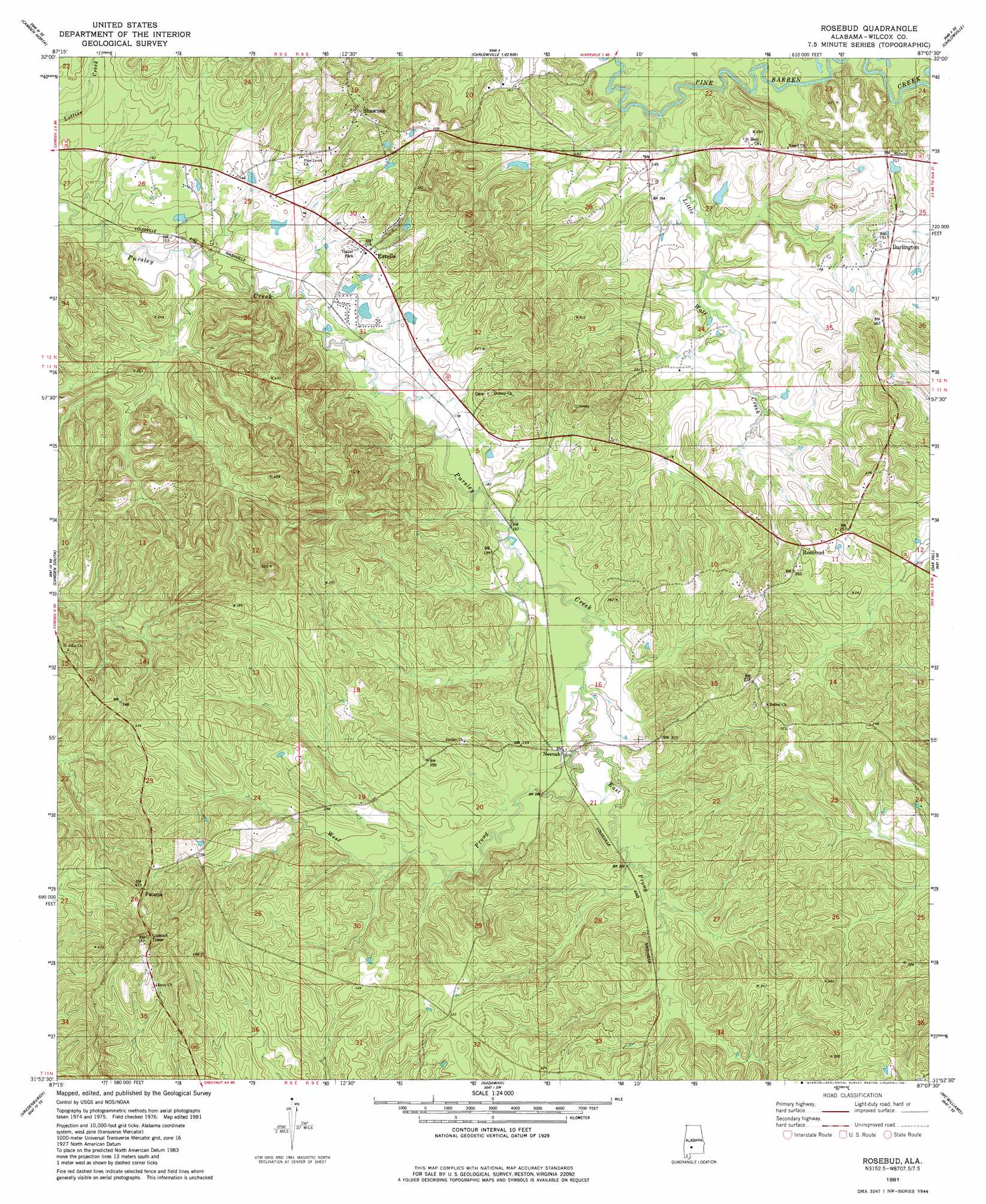
Rosebud Topo Map Alabama
To zoom in, hover over the map of Rosebud
USGS Topo Quad 31087h2 - 1:24,000 scale
| Topo Map Name: | Rosebud |
| USGS Topo Quad ID: | 31087h2 |
| Print Size: | ca. 21 1/4" wide x 27" high |
| Southeast Coordinates: | 31.875° N latitude / 87.125° W longitude |
| Map Center Coordinates: | 31.9375° N latitude / 87.1875° W longitude |
| U.S. State: | AL |
| Filename: | o31087h2.jpg |
| Download Map JPG Image: | Rosebud topo map 1:24,000 scale |
| Map Type: | Topographic |
| Topo Series: | 7.5´ |
| Map Scale: | 1:24,000 |
| Source of Map Images: | United States Geological Survey (USGS) |
| Alternate Map Versions: |
Rosebud AL 1981, updated 1981 Download PDF Buy paper map Rosebud AL 2011 Download PDF Buy paper map Rosebud AL 2014 Download PDF Buy paper map |
1:24,000 Topo Quads surrounding Rosebud
Catherine |
Crumptonia |
Tasso |
Elm Bluff |
Pleasant Hill |
Lee Long Bridge |
Camden North |
Tilden |
Carlowville |
Minter |
Coy |
Camden South |
Rosebud |
Oak Hill |
Pine Apple North |
Hybart |
Vredenburgh |
Nadawah |
Mcwilliams |
Pine Apple South |
Franklin |
Natchez |
Beatrice |
Skinnerton |
Bethel |
> Back to 31087e1 at 1:100,000 scale
> Back to 31086a1 at 1:250,000 scale
> Back to U.S. Topo Maps home
Rosebud topo map: Gazetteer
Rosebud: Populated Places
Darlington elevation 60m 196′Estelle elevation 55m 180′
Fatama elevation 121m 396′
Neenah elevation 62m 203′
Rosebud elevation 77m 252′
Shawnee elevation 97m 318′
Rosebud: Post Offices
Darlington Post Office elevation 58m 190′Rosebud: Streams
East Prong Pursley Creek elevation 58m 190′Little Wolf Creek elevation 37m 121′
West Prong Pursley Creek elevation 58m 190′
Rosebud digital topo map on disk
Buy this Rosebud topo map showing relief, roads, GPS coordinates and other geographical features, as a high-resolution digital map file on DVD:
Gulf Coast (LA, MS, AL, FL) & Southwestern Georgia
Buy digital topo maps: Gulf Coast (LA, MS, AL, FL) & Southwestern Georgia
 & Southwestern Georgia map DVD")