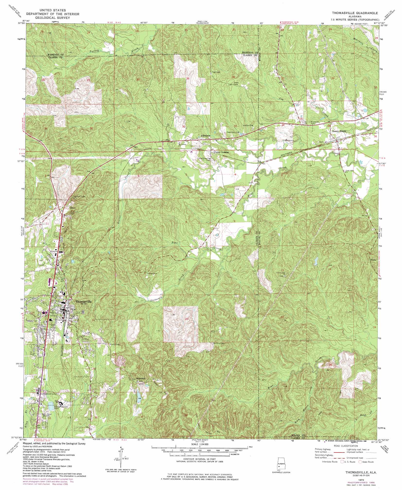
Thomasville Topo Map Alabama
To zoom in, hover over the map of Thomasville
USGS Topo Quad 31087h6 - 1:24,000 scale
| Topo Map Name: | Thomasville |
| USGS Topo Quad ID: | 31087h6 |
| Print Size: | ca. 21 1/4" wide x 27" high |
| Southeast Coordinates: | 31.875° N latitude / 87.625° W longitude |
| Map Center Coordinates: | 31.9375° N latitude / 87.6875° W longitude |
| U.S. State: | AL |
| Filename: | o31087h6.jpg |
| Download Map JPG Image: | Thomasville topo map 1:24,000 scale |
| Map Type: | Topographic |
| Topo Series: | 7.5´ |
| Map Scale: | 1:24,000 |
| Source of Map Images: | United States Geological Survey (USGS) |
| Alternate Map Versions: |
Thomasville AL 1973, updated 1977 Download PDF Buy paper map Thomasville AL 1973, updated 1986 Download PDF Buy paper map Thomasville AL 2011 Download PDF Buy paper map Thomasville AL 2014 Download PDF Buy paper map |
1:24,000 Topo Quads surrounding Thomasville
Myrtlewood South |
Miller |
Magnolia |
Flatwood |
Catherine |
Nanafalia |
Sweet Water |
Surginer |
Kimbrough |
Lee Long Bridge |
Morvin |
Bashi |
Thomasville |
Pine Hill |
Coy |
Mcentyre |
Fulton West |
Fulton East |
Lower Peach Tree |
Hybart |
Winn |
Grove Hill |
Whatley |
Chance |
Franklin |
> Back to 31087e1 at 1:100,000 scale
> Back to 31086a1 at 1:250,000 scale
> Back to U.S. Topo Maps home
Thomasville topo map: Gazetteer
Thomasville: Arches
Double Natural Bridges elevation 65m 213′Thomasville: Dams
Homer A Crow Dam elevation 127m 416′Thomasville Sewer Lagoon Dam elevation 102m 334′
Thomasville: Parks
D F Anderson Field elevation 112m 367′Thomasville: Populated Places
Atkeison elevation 71m 232′Finley Crossing elevation 65m 213′
Hestle elevation 80m 262′
Roundhill elevation 140m 459′
Sunny South elevation 50m 164′
Thomasville elevation 116m 380′
Thomasville: Post Offices
Air Mount Post Office (historical) elevation 70m 229′Sunny South Post Office elevation 47m 154′
Thomasville: Reservoirs
Lake Crow elevation 127m 416′Thomasville Sewer Lagoon elevation 102m 334′
Thomasville: Streams
Bear Creek elevation 45m 147′Lewis Creek elevation 37m 121′
Pool Creek elevation 33m 108′
Rock House Creek elevation 45m 147′
Sixteenth Creek elevation 58m 190′
Thomasville digital topo map on disk
Buy this Thomasville topo map showing relief, roads, GPS coordinates and other geographical features, as a high-resolution digital map file on DVD:
Gulf Coast (LA, MS, AL, FL) & Southwestern Georgia
Buy digital topo maps: Gulf Coast (LA, MS, AL, FL) & Southwestern Georgia
 & Southwestern Georgia map DVD")