Citronelle East Topo Map Alabama
To zoom in, hover over the map of Citronelle East
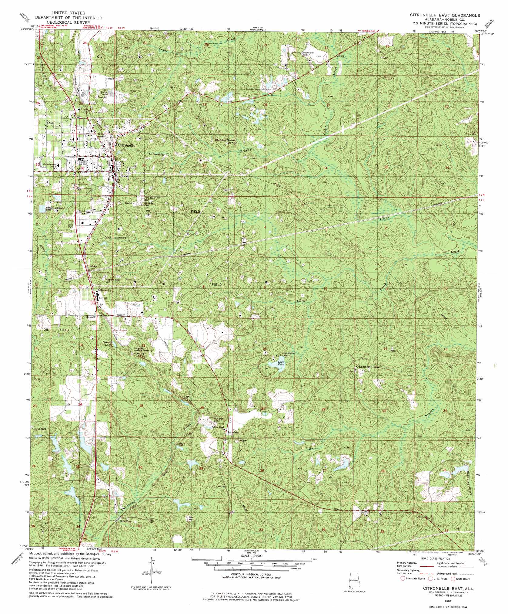
USGS Topo Quad 31088a2 - 1:24,000 scale
| Topo Map Name: | Citronelle East |
| USGS Topo Quad ID: | 31088a2 |
| Print Size: | ca. 21 1/4" wide x 27" high |
| Southeast Coordinates: | 31° N latitude / 88.125° W longitude |
| Map Center Coordinates: | 31.0625° N latitude / 88.1875° W longitude |
| U.S. State: | AL |
| Filename: | o31088a2.jpg |
| Download Map JPG Image: | Citronelle East topo map 1:24,000 scale |
| Map Type: | Topographic |
| Topo Series: | 7.5´ |
| Map Scale: | 1:24,000 |
| Source of Map Images: | United States Geological Survey (USGS) |
| Alternate Map Versions: |
Citronelle East AL 1982, updated 1982 Download PDF Buy paper map Citronelle East AL 1982, updated 1984 Download PDF Buy paper map Citronelle East AL 2011 Download PDF Buy paper map Citronelle East AL 2014 Download PDF Buy paper map |
1:24,000 Topo Quads surrounding Citronelle East
Fruitdale |
Vinegar Bend |
Seaboard |
Mcintosh |
Gin House Island |
Rounsaville |
Deer Park |
Sims Chapel |
Calvert |
Bilbo Island |
Brown Town |
Citronelle West |
Citronelle East |
Mount Vernon |
Stiggins Lake |
Earlville |
Georgetown |
Chunchula |
Creola |
The Basin |
Howell |
Semmes |
Kushla |
Chickasaw |
Hurricane |
> Back to 31088a1 at 1:100,000 scale
> Back to 31088a1 at 1:250,000 scale
> Back to U.S. Topo Maps home
Citronelle East topo map: Gazetteer
Citronelle East: Crossings
Vienna Ferry (historical) elevation 61m 200′Citronelle East: Dams
Echo Lake Dam elevation 56m 183′H G Quinnelly Dam elevation 68m 223′
Howard E Smith Dam elevation 54m 177′
Pratt Turner Dam elevation 47m 154′
Citronelle East: Parks
Cedar Creek State Park elevation 56m 183′Citronelle East: Populated Places
Citronelle elevation 94m 308′Lambert elevation 91m 298′
Lambert Grove elevation 75m 246′
Russell elevation 98m 321′
Scoutshire Woods elevation 52m 170′
Sidney elevation 97m 318′
Citronelle East: Reservoirs
Echo Lake elevation 56m 183′H G Quinnelly Lake elevation 68m 223′
Howard E Smith Lake elevation 54m 177′
Spring Lake elevation 78m 255′
Citronelle East: Springs
Cherokee Mineral Springs elevation 36m 118′Citronelle East: Streams
Citronelle Branch elevation 27m 88′Little Creek elevation 17m 55′
Citronelle East digital topo map on disk
Buy this Citronelle East topo map showing relief, roads, GPS coordinates and other geographical features, as a high-resolution digital map file on DVD:
Gulf Coast (LA, MS, AL, FL) & Southwestern Georgia
Buy digital topo maps: Gulf Coast (LA, MS, AL, FL) & Southwestern Georgia
 & Southwestern Georgia map DVD")