Mclain Topo Map Mississippi
To zoom in, hover over the map of Mclain
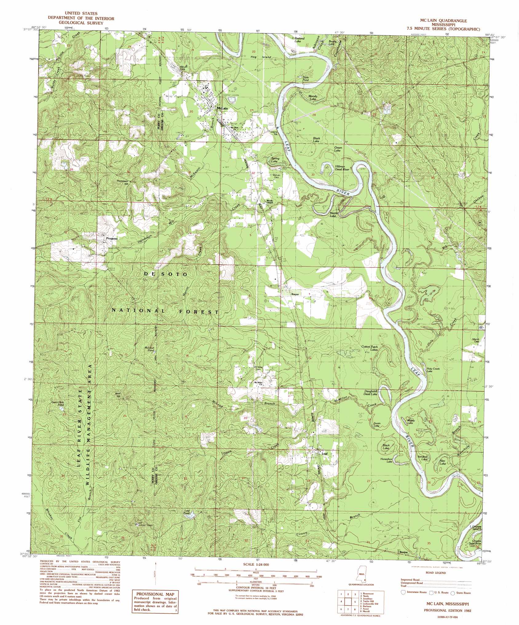
USGS Topo Quad 31088a7 - 1:24,000 scale
| Topo Map Name: | Mclain |
| USGS Topo Quad ID: | 31088a7 |
| Print Size: | ca. 21 1/4" wide x 27" high |
| Southeast Coordinates: | 31° N latitude / 88.75° W longitude |
| Map Center Coordinates: | 31.0625° N latitude / 88.8125° W longitude |
| U.S. State: | MS |
| Filename: | o31088a7.jpg |
| Download Map JPG Image: | Mclain topo map 1:24,000 scale |
| Map Type: | Topographic |
| Topo Series: | 7.5´ |
| Map Scale: | 1:24,000 |
| Source of Map Images: | United States Geological Survey (USGS) |
| Alternate Map Versions: |
McLain MS 1982, updated 1983 Download PDF Buy paper map McLain MS 2000, updated 2003 Download PDF Buy paper map McLain MS 2012 Download PDF Buy paper map McLain MS 2015 Download PDF Buy paper map |
| FStopo: | US Forest Service topo McLain is available: Download FStopo PDF Download FStopo TIF |
1:24,000 Topo Quads surrounding Mclain
Ovett Se |
Richton |
Brewer |
Avera |
Clark |
New Augusta |
Beaumont |
Neely |
Jonathan |
Leakesville |
Janice |
Taylor Hill |
Mclain |
Leakesville Sw |
Vernal |
Bond Pond |
Barbara |
Avent |
Merrill |
Lucedale |
Whites Crossing |
Ramsey Springs |
Benndale |
Basin |
Agricola |
> Back to 31088a1 at 1:100,000 scale
> Back to 31088a1 at 1:250,000 scale
> Back to U.S. Topo Maps home
Mclain topo map: Gazetteer
Mclain: Dams
Harvison Lake Dam elevation 33m 108′McLain Sewage Lagoon Dam elevation 20m 65′
Mclain: Flats
Dunnam Field elevation 21m 68′Mclain: Islands
Hog Island elevation 22m 72′Mclain: Lakes
Alec Lake elevation 13m 42′Black Lake elevation 15m 49′
Black Lake elevation 18m 59′
Breland Lake elevation 21m 68′
Brushy Lake elevation 23m 75′
Cotton Patch Lakes elevation 15m 49′
Daughdrill Dead Lake elevation 15m 49′
Duck Pond elevation 18m 59′
Green Lake elevation 18m 59′
Hillman Dead River elevation 17m 55′
Holy Creek Lake elevation 15m 49′
Horseshoe Lake elevation 15m 49′
Little Cowans Dead River elevation 15m 49′
Makay Lake elevation 15m 49′
Merritt Lake elevation 15m 49′
Moody Lake elevation 18m 59′
Sandbar Lake elevation 15m 49′
Spring Lake elevation 18m 59′
Swan Lake elevation 15m 49′
Mclain: Populated Places
Benjoe elevation 18m 59′Leaf elevation 29m 95′
McLain elevation 22m 72′
Progress elevation 43m 141′
Royce elevation 23m 75′
Mclain: Reservoirs
Gator Hole Pond elevation 46m 150′Leaf Pond elevation 52m 170′
McLeod Pond elevation 52m 170′
Mclain: Streams
Atkinson Creek elevation 18m 59′Big Oktibee Creek elevation 14m 45′
Courthouse Creek elevation 30m 98′
Cowart Branch elevation 13m 42′
Davis Creek elevation 17m 55′
Flat Branch elevation 34m 111′
Harverson Mill Creek elevation 21m 68′
Holy Creek elevation 15m 49′
McLeod Branch elevation 18m 59′
McMillan Creek elevation 15m 49′
McSwain Branch elevation 18m 59′
Merritt Creek elevation 15m 49′
Waterhole Branch elevation 20m 65′
Weldy Creek elevation 27m 88′
Mclain: Summits
Thompson Hill elevation 71m 232′Wolf Hill elevation 61m 200′
Mclain digital topo map on disk
Buy this Mclain topo map showing relief, roads, GPS coordinates and other geographical features, as a high-resolution digital map file on DVD:
Gulf Coast (LA, MS, AL, FL) & Southwestern Georgia
Buy digital topo maps: Gulf Coast (LA, MS, AL, FL) & Southwestern Georgia
 & Southwestern Georgia map DVD")