Calvert Topo Map Alabama
To zoom in, hover over the map of Calvert
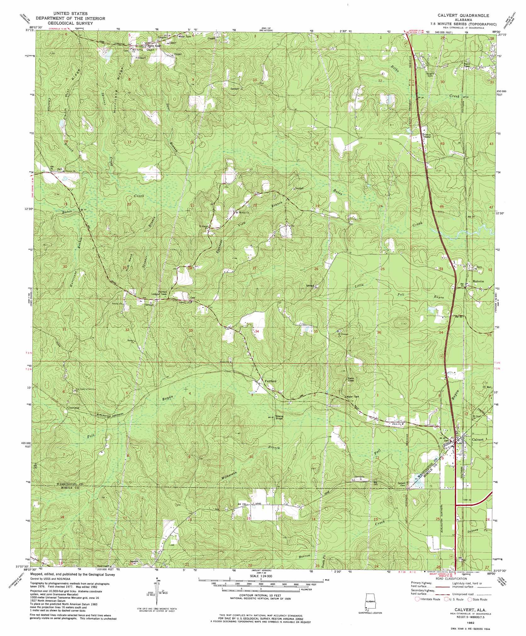
USGS Topo Quad 31088b1 - 1:24,000 scale
| Topo Map Name: | Calvert |
| USGS Topo Quad ID: | 31088b1 |
| Print Size: | ca. 21 1/4" wide x 27" high |
| Southeast Coordinates: | 31.125° N latitude / 88° W longitude |
| Map Center Coordinates: | 31.1875° N latitude / 88.0625° W longitude |
| U.S. State: | AL |
| Filename: | o31088b1.jpg |
| Download Map JPG Image: | Calvert topo map 1:24,000 scale |
| Map Type: | Topographic |
| Topo Series: | 7.5´ |
| Map Scale: | 1:24,000 |
| Source of Map Images: | United States Geological Survey (USGS) |
| Alternate Map Versions: |
Calvert AL 1982, updated 1982 Download PDF Buy paper map Calvert AL 2011 Download PDF Buy paper map Calvert AL 2014 Download PDF Buy paper map |
1:24,000 Topo Quads surrounding Calvert
Chatom |
Rutan |
Wagarville |
Prestwick |
Choctaw Bluff |
Vinegar Bend |
Seaboard |
Mcintosh |
Gin House Island |
Carlton |
Deer Park |
Sims Chapel |
Calvert |
Bilbo Island |
Tensaw |
Citronelle West |
Citronelle East |
Mount Vernon |
Stiggins Lake |
Vaughn |
Georgetown |
Chunchula |
Creola |
The Basin |
Bay Minette North |
> Back to 31088a1 at 1:100,000 scale
> Back to 31088a1 at 1:250,000 scale
> Back to U.S. Topo Maps home
Calvert topo map: Gazetteer
Calvert: Bridges
Bowing Bridge elevation 20m 65′Calvert: Capes
Hub Neck elevation 59m 193′Calvert: Crossings
Manns Ferry (historical) elevation 5m 16′Calvert: Populated Places
Calvert elevation 14m 45′Chestang elevation 34m 111′
Fairford elevation 24m 78′
Happy Hill elevation 56m 183′
Malcolm elevation 12m 39′
Reid Settlement elevation 76m 249′
Calvert: Post Offices
Calvert Post Office elevation 13m 42′Malcolm Post Office elevation 12m 39′
Calvert: Ridges
Coon Hill Ridge elevation 43m 141′Hurricane Ridge elevation 45m 147′
Calvert: Streams
Choctaw Branch elevation 14m 45′Deer Branch elevation 12m 39′
Hurricane Branch elevation 14m 45′
Johnston Branch elevation 14m 45′
Skinner Branch elevation 16m 52′
Skinner Creek elevation 23m 75′
South Fork Borrow Creek elevation 27m 88′
Wilkerson Branch elevation 19m 62′
Calvert: Summits
Dove Roost Hill elevation 78m 255′Calvert digital topo map on disk
Buy this Calvert topo map showing relief, roads, GPS coordinates and other geographical features, as a high-resolution digital map file on DVD:
Gulf Coast (LA, MS, AL, FL) & Southwestern Georgia
Buy digital topo maps: Gulf Coast (LA, MS, AL, FL) & Southwestern Georgia
 & Southwestern Georgia map DVD")