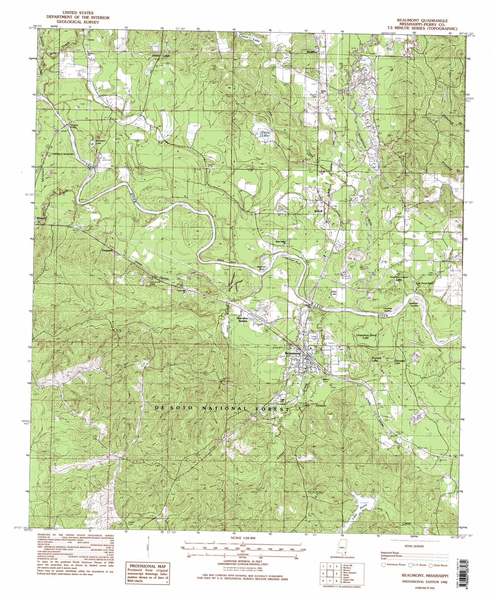
Beaumont Topo Map Mississippi
To zoom in, hover over the map of Beaumont
USGS Topo Quad 31088b8 - 1:24,000 scale
| Topo Map Name: | Beaumont |
| USGS Topo Quad ID: | 31088b8 |
| Print Size: | ca. 21 1/4" wide x 27" high |
| Southeast Coordinates: | 31.125° N latitude / 88.875° W longitude |
| Map Center Coordinates: | 31.1875° N latitude / 88.9375° W longitude |
| U.S. State: | MS |
| Filename: | o31088b8.jpg |
| Download Map JPG Image: | Beaumont topo map 1:24,000 scale |
| Map Type: | Topographic |
| Topo Series: | 7.5´ |
| Map Scale: | 1:24,000 |
| Source of Map Images: | United States Geological Survey (USGS) |
| Alternate Map Versions: |
Beaumont MS 1982, updated 1982 Download PDF Buy paper map Beaumont MS 1982, updated 1982 Download PDF Buy paper map Beaumont MS 2000, updated 2003 Download PDF Buy paper map Beaumont MS 2012 Download PDF Buy paper map Beaumont MS 2015 Download PDF Buy paper map |
| FStopo: | US Forest Service topo Beaumont is available: Download FStopo PDF Download FStopo TIF |
1:24,000 Topo Quads surrounding Beaumont
Barrontown |
Ovett |
Rhodes |
Mulberry |
Piave |
Carterville |
Ovett Se |
Richton |
Brewer |
Avera |
Mclaurin |
New Augusta |
Beaumont |
Neely |
Jonathan |
Brooklyn |
Janice |
Taylor Hill |
Mclain |
Leakesville Sw |
Bond |
Bond Pond |
Barbara |
Avent |
Merrill |
> Back to 31088a1 at 1:100,000 scale
> Back to 31088a1 at 1:250,000 scale
> Back to U.S. Topo Maps home
Beaumont topo map: Gazetteer
Beaumont: Bars
Breakover Sandbar elevation 23m 75′Longfield Sandbar elevation 19m 62′
Beaumont: Bends
Racetrack Bend elevation 22m 72′Beaumont: Bridges
Wingate Bridge elevation 23m 75′Beaumont: Cliffs
Bland Bluff elevation 21m 68′Fairhope Bluff elevation 19m 62′
Reeds Bluff elevation 28m 91′
Beaumont: Dams
Crane Lake Dam elevation 48m 157′Lake Perry Dam elevation 38m 124′
Perry Lake Dam elevation 40m 131′
Beaumont: Lakes
American Legion Lake elevation 21m 68′Breland Lake elevation 24m 78′
Deitz Lake elevation 24m 78′
Horseshoe Bend Lake elevation 22m 72′
Lott Dead River elevation 25m 82′
McSwain Lake elevation 21m 68′
Moffett Lake elevation 19m 62′
Palmetto Lake elevation 24m 78′
Perry Lake elevation 37m 121′
Beaumont: Populated Places
Beaumont elevation 28m 91′Benmore elevation 42m 137′
Ferguson elevation 30m 98′
Hercules Station elevation 28m 91′
Kittrell elevation 30m 98′
Beaumont: Reservoirs
Crane Lake elevation 49m 160′Inland Lakes elevation 40m 131′
Lake Perry elevation 43m 141′
Beaumont: Streams
Bogue Homo elevation 22m 72′Carter Creek elevation 25m 82′
Coleman Creek elevation 20m 65′
Crane Creek elevation 24m 78′
Mill Creek elevation 25m 82′
Thompson Creek elevation 19m 62′
Beaumont digital topo map on disk
Buy this Beaumont topo map showing relief, roads, GPS coordinates and other geographical features, as a high-resolution digital map file on DVD:
Gulf Coast (LA, MS, AL, FL) & Southwestern Georgia
Buy digital topo maps: Gulf Coast (LA, MS, AL, FL) & Southwestern Georgia
 & Southwestern Georgia map DVD")