Hattiesburg Sw Topo Map Mississippi
To zoom in, hover over the map of Hattiesburg Sw
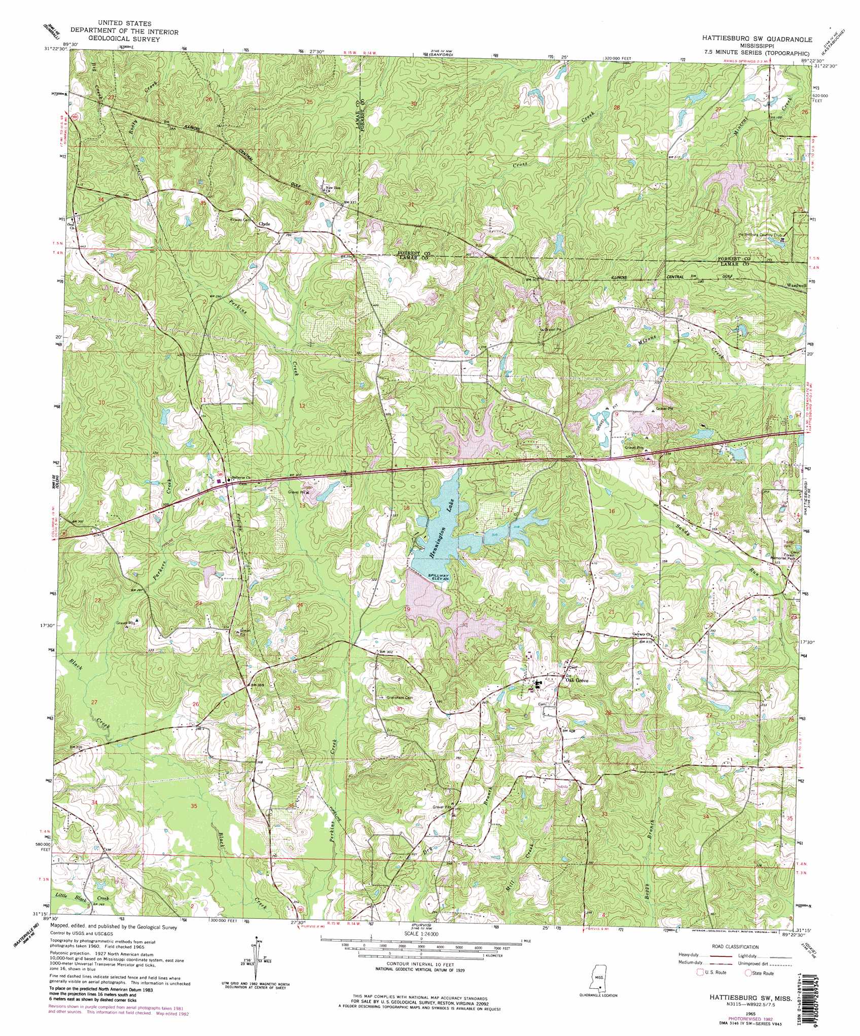
USGS Topo Quad 31089c4 - 1:24,000 scale
| Topo Map Name: | Hattiesburg Sw |
| USGS Topo Quad ID: | 31089c4 |
| Print Size: | ca. 21 1/4" wide x 27" high |
| Southeast Coordinates: | 31.25° N latitude / 89.375° W longitude |
| Map Center Coordinates: | 31.3125° N latitude / 89.4375° W longitude |
| U.S. State: | MS |
| Filename: | o31089c4.jpg |
| Download Map JPG Image: | Hattiesburg Sw topo map 1:24,000 scale |
| Map Type: | Topographic |
| Topo Series: | 7.5´ |
| Map Scale: | 1:24,000 |
| Source of Map Images: | United States Geological Survey (USGS) |
| Alternate Map Versions: |
Hattiesburg SW MS 1965, updated 1966 Download PDF Buy paper map Hattiesburg SW MS 1965, updated 1977 Download PDF Buy paper map Hattiesburg SW MS 1965, updated 1982 Download PDF Buy paper map Hattiesburg SW MS 1965, updated 1982 Download PDF Buy paper map Hattiesburg SW MS 2012 Download PDF Buy paper map Hattiesburg SW MS 2015 Download PDF Buy paper map |
1:24,000 Topo Quads surrounding Hattiesburg Sw
Lake Mike Connor |
Williamsburg |
Seminary |
Moselle |
Ellisville |
Bassfield |
Sumrall |
Sanford |
Eastabuchie |
Barrontown |
Improve |
Oloh |
Hattiesburg Sw |
Hattiesburg |
Carterville |
Pinebur |
Baxterville Ne |
Purvis |
Dixie |
Mclaurin |
Baxterville Sw |
Baxterville |
Lumberton |
Rock Hill |
Brooklyn |
> Back to 31089a1 at 1:100,000 scale
> Back to 31088a1 at 1:250,000 scale
> Back to U.S. Topo Maps home
Hattiesburg Sw topo map: Gazetteer
Hattiesburg Sw: Dams
A G McInturff Dam elevation 88m 288′Bennett York Dam elevation 105m 344′
Lake Serene Dam elevation 90m 295′
Lake Serene East Dam elevation 94m 308′
Lake Serene North Dam elevation 94m 308′
Lake Serene South Dam elevation 90m 295′
Lake Serene Southeast Dam elevation 103m 337′
Leon Eubanks Pond Dam elevation 85m 278′
W J Morris Pond Dam elevation 91m 298′
Hattiesburg Sw: Populated Places
Breland elevation 99m 324′Clyde elevation 129m 423′
Country Club Estates elevation 76m 249′
East Lakewood elevation 63m 206′
Lake Serene North elevation 111m 364′
Lake Serene South elevation 101m 331′
Oak Forrest elevation 104m 341′
Oak Grove elevation 125m 410′
Wardwell elevation 64m 209′
West Hattiesburg elevation 77m 252′
Hattiesburg Sw: Reservoirs
Cole Lake elevation 98m 321′Hennington Lake elevation 90m 295′
Hattiesburg Sw: Streams
Parkers Creek elevation 80m 262′Hattiesburg Sw digital topo map on disk
Buy this Hattiesburg Sw topo map showing relief, roads, GPS coordinates and other geographical features, as a high-resolution digital map file on DVD:
Gulf Coast (LA, MS, AL, FL) & Southwestern Georgia
Buy digital topo maps: Gulf Coast (LA, MS, AL, FL) & Southwestern Georgia
 & Southwestern Georgia map DVD")