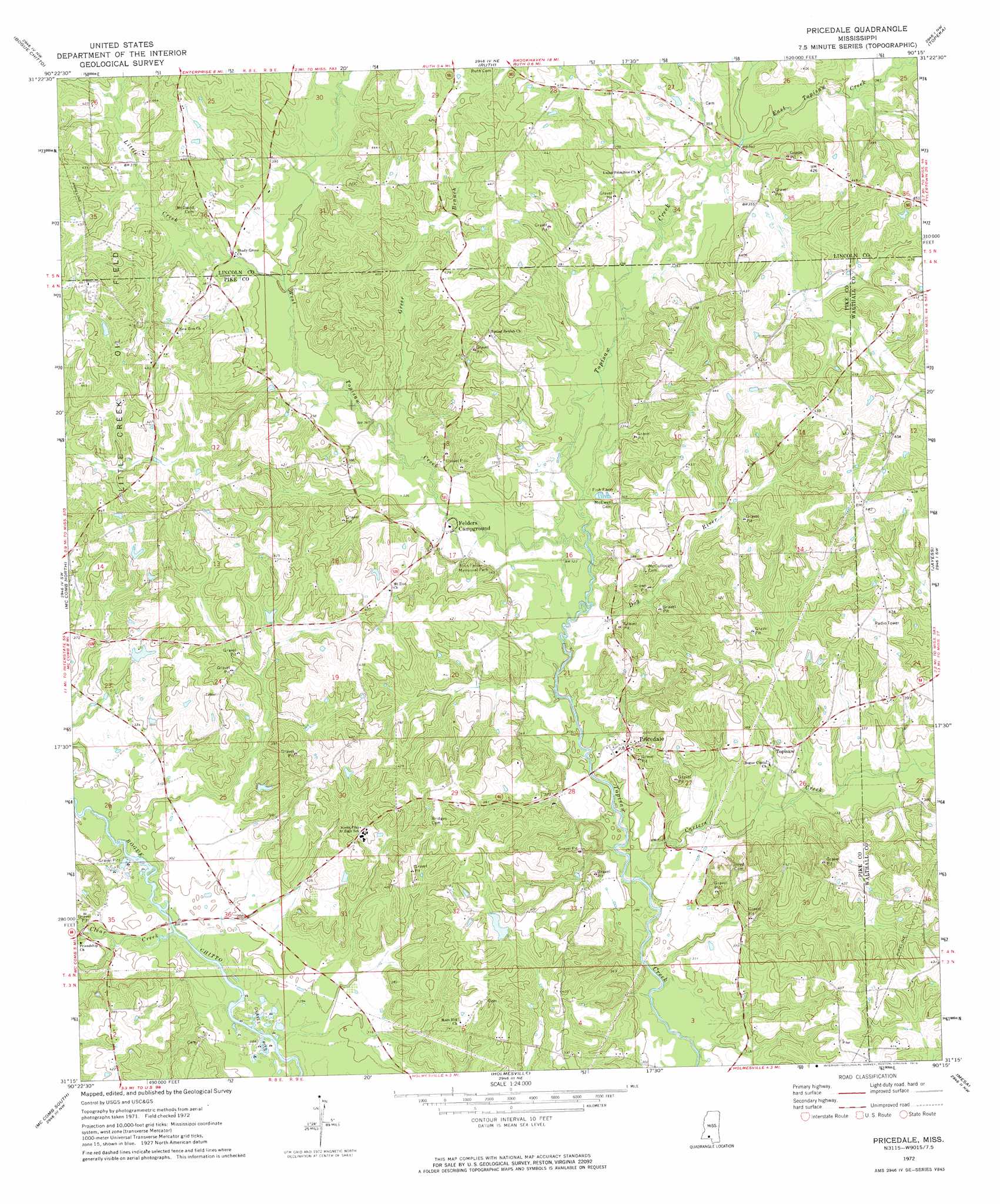
Pricedale Topo Map Mississippi
To zoom in, hover over the map of Pricedale
USGS Topo Quad 31090c3 - 1:24,000 scale
| Topo Map Name: | Pricedale |
| USGS Topo Quad ID: | 31090c3 |
| Print Size: | ca. 21 1/4" wide x 27" high |
| Southeast Coordinates: | 31.25° N latitude / 90.25° W longitude |
| Map Center Coordinates: | 31.3125° N latitude / 90.3125° W longitude |
| U.S. State: | MS |
| Filename: | o31090c3.jpg |
| Download Map JPG Image: | Pricedale topo map 1:24,000 scale |
| Map Type: | Topographic |
| Topo Series: | 7.5´ |
| Map Scale: | 1:24,000 |
| Source of Map Images: | United States Geological Survey (USGS) |
| Alternate Map Versions: |
Pricedale MS 1972, updated 1974 Download PDF Buy paper map Pricedale MS 2012 Download PDF Buy paper map Pricedale MS 2015 Download PDF Buy paper map |
1:24,000 Topo Quads surrounding Pricedale
Zetus |
Brookhaven |
Fair Oak Springs |
Nola |
Monticello |
West Lincoln |
Bogue Chitto |
Ruth |
Topeka |
Tilton |
Auburn |
Mccomb North |
Pricedale |
Jayess |
Darbun |
Lake Tangipahoa |
Mccomb South |
Holmesville |
Mesa |
Kokomo |
Terrys Creek |
Osyka |
Progress |
Tylertown |
Tylertown Se |
> Back to 31090a1 at 1:100,000 scale
> Back to 31090a1 at 1:250,000 scale
> Back to U.S. Topo Maps home
Pricedale topo map: Gazetteer
Pricedale: Bridges
Quinns Bridge elevation 87m 285′Pricedale: Dams
Guy Lake Dam elevation 122m 400′Nunnery Lake Dam elevation 116m 380′
Pinehaven Lake Dam elevation 122m 400′
Spring Lake Dam elevation 129m 423′
Pricedale: Oilfields
Little Creek Oil Field elevation 133m 436′Pricedale: Populated Places
Pricedale elevation 102m 334′Topisaw elevation 108m 354′
Pricedale: Streams
Carters Creek elevation 86m 282′Clear Creek elevation 89m 291′
Dog River elevation 91m 298′
East Topisaw Creek elevation 105m 344′
Greer Branch elevation 100m 328′
Little Creek elevation 105m 344′
West Topisaw Creek elevation 94m 308′
Pricedale digital topo map on disk
Buy this Pricedale topo map showing relief, roads, GPS coordinates and other geographical features, as a high-resolution digital map file on DVD: