Brookhaven Topo Map Mississippi
To zoom in, hover over the map of Brookhaven
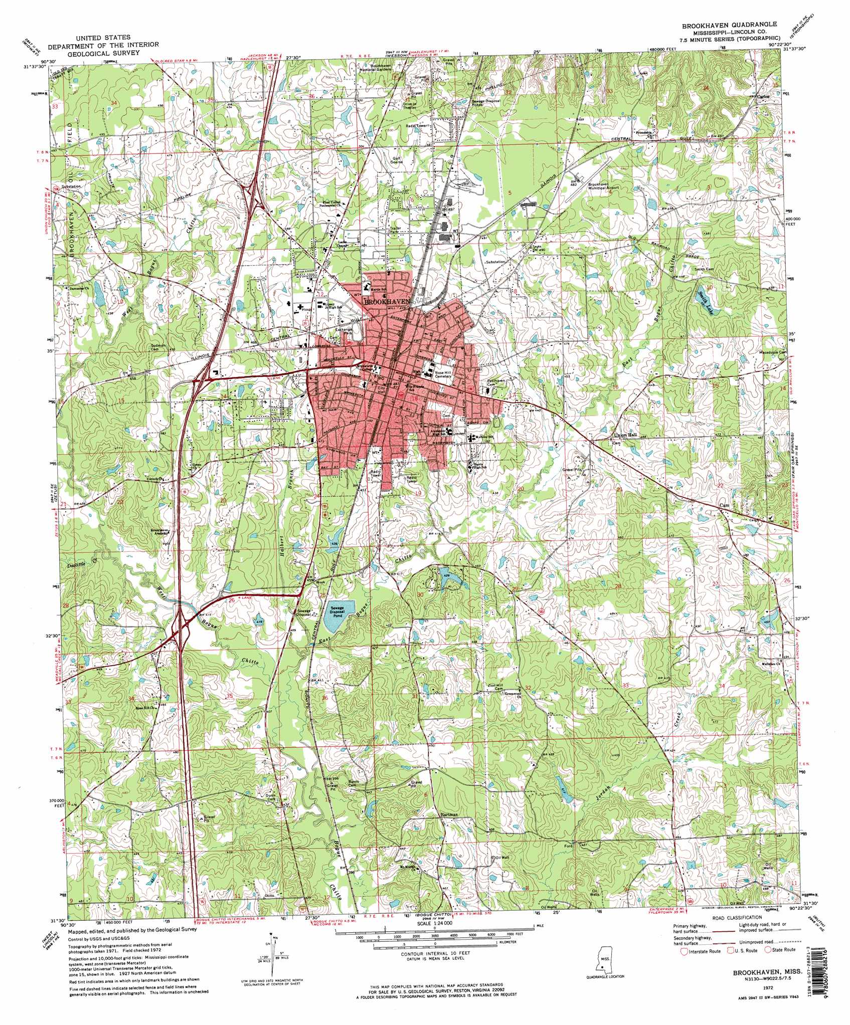
USGS Topo Quad 31090e4 - 1:24,000 scale
| Topo Map Name: | Brookhaven |
| USGS Topo Quad ID: | 31090e4 |
| Print Size: | ca. 21 1/4" wide x 27" high |
| Southeast Coordinates: | 31.5° N latitude / 90.375° W longitude |
| Map Center Coordinates: | 31.5625° N latitude / 90.4375° W longitude |
| U.S. State: | MS |
| Filename: | o31090e4.jpg |
| Download Map JPG Image: | Brookhaven topo map 1:24,000 scale |
| Map Type: | Topographic |
| Topo Series: | 7.5´ |
| Map Scale: | 1:24,000 |
| Source of Map Images: | United States Geological Survey (USGS) |
| Alternate Map Versions: |
Brookhaven MS 1972, updated 1974 Download PDF Buy paper map Brookhaven MS 1972, updated 1974 Download PDF Buy paper map Brookhaven MS 2012 Download PDF Buy paper map Brookhaven MS 2015 Download PDF Buy paper map |
1:24,000 Topo Quads surrounding Brookhaven
Barlow |
Smyrna |
Hazlehurst |
Shady Grove |
Georgetown |
Caseyville |
Midway |
Wesson |
Stronghope |
Oma |
Mccall Creek |
Zetus |
Brookhaven |
Fair Oak Springs |
Nola |
Little Springs |
West Lincoln |
Bogue Chitto |
Ruth |
Topeka |
Smithdale |
Auburn |
Mccomb North |
Pricedale |
Jayess |
> Back to 31090e1 at 1:100,000 scale
> Back to 31090a1 at 1:250,000 scale
> Back to U.S. Topo Maps home
Brookhaven topo map: Gazetteer
Brookhaven: Airports
Brookhaven-Lincoln County Airport elevation 147m 482′Brookhaven: Crossings
Interchange 38 elevation 130m 426′Interchange 40 elevation 152m 498′
Interchange 42 elevation 147m 482′
Brookhaven: Dams
Bes Arrington Lake Dam elevation 133m 436′Brookhaven Sewage Lagoon Dam elevation 128m 419′
C C Clarke Lake Dam elevation 128m 419′
Davis Lake Dam elevation 131m 429′
Frank Hartman Lake Dam elevation 143m 469′
Lakewood Village Lake Dam elevation 131m 429′
Smith Lake Dam elevation 141m 462′
Brookhaven: Parks
Brookhaven City Park elevation 150m 492′Exchange Park elevation 146m 479′
Brookhaven: Populated Places
Brookhaven elevation 149m 488′Cam elevation 153m 501′
Carlos elevation 150m 492′
Friendship elevation 152m 498′
Hartman elevation 142m 465′
Pearlhaven elevation 149m 488′
Brookhaven: Reservoirs
Smith Lake elevation 141m 462′Brookhaven: Streams
Doolittle Creek elevation 124m 406′East Bogue Chitto elevation 118m 387′
Halbert Branch elevation 121m 396′
West Bogue Chitto elevation 118m 387′
Brookhaven digital topo map on disk
Buy this Brookhaven topo map showing relief, roads, GPS coordinates and other geographical features, as a high-resolution digital map file on DVD: