Moreauville Topo Map Louisiana
To zoom in, hover over the map of Moreauville
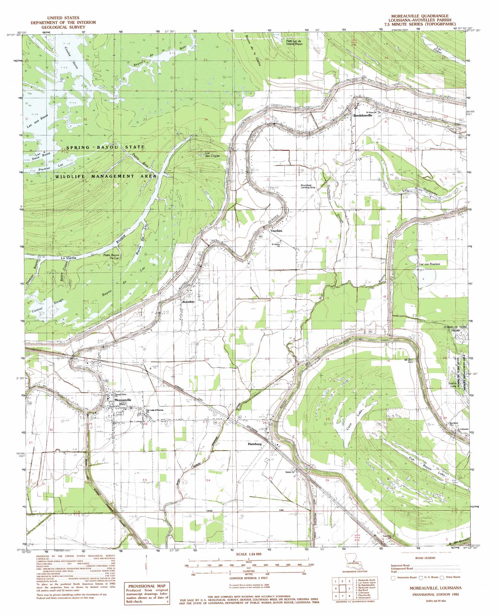
USGS Topo Quad 31091a8 - 1:24,000 scale
| Topo Map Name: | Moreauville |
| USGS Topo Quad ID: | 31091a8 |
| Print Size: | ca. 21 1/4" wide x 27" high |
| Southeast Coordinates: | 31° N latitude / 91.875° W longitude |
| Map Center Coordinates: | 31.0625° N latitude / 91.9375° W longitude |
| U.S. State: | LA |
| Filename: | o31091a8.jpg |
| Download Map JPG Image: | Moreauville topo map 1:24,000 scale |
| Map Type: | Topographic |
| Topo Series: | 7.5´ |
| Map Scale: | 1:24,000 |
| Source of Map Images: | United States Geological Survey (USGS) |
| Alternate Map Versions: |
Moreauville LA 1982, updated 1983 Download PDF Buy paper map Moreauville LA 1996, updated 1999 Download PDF Buy paper map Moreauville LA 2012 Download PDF Buy paper map Moreauville LA 2015 Download PDF Buy paper map |
1:24,000 Topo Quads surrounding Moreauville
Buckeye |
Powell Point |
Larto Lake South |
Acme |
Slocum |
Effie |
Marksville North |
Lac Sainte Agnes |
Ile Natchitoches |
Shaw |
Belle D'Eau |
Marksville South |
Moreauville |
Big Bend |
Turnbull Island |
Bunkie |
Cottonport |
Plaucheville |
Simmesport |
Innis |
Whiteville |
Morrow |
Bayou Jack |
Bayou Current |
Batchelor |
> Back to 31091a1 at 1:100,000 scale
> Back to 31090a1 at 1:250,000 scale
> Back to U.S. Topo Maps home
Moreauville topo map: Gazetteer
Moreauville: Airports
Brumfield Landing Strip elevation 16m 52′Parham Strip elevation 15m 49′
Moreauville: Canals
Bayou Roseau Drainage Canal elevation 13m 42′Moreauville: Channels
Bayou du Lac elevation 13m 42′Moreauville: Guts
Bayou Creux elevation 12m 39′Bayou Du Lac elevation 13m 42′
Petite Baie elevation 12m 39′
Petite Bayou du Lac elevation 12m 39′
Premier Bayou elevation 12m 39′
Moreauville: Lakes
Bayou Creux elevation 12m 39′Bayou du Lac elevation 13m 42′
Central Slough elevation 13m 42′
Coco Lake elevation 13m 42′
Coulee Noire elevation 13m 42′
Fish Bayou Lake elevation 12m 39′
Lac aux Cygnes elevation 13m 42′
Lac aux Roseaux elevation 11m 36′
Lac Bec Croche elevation 13m 42′
Lac Didier elevation 12m 39′
Lac François elevation 12m 39′
Lac Gabriel elevation 13m 42′
Lac Tête de Boeuf elevation 13m 42′
Moreauville: Parks
Spring Bayou State Wildlife Management Area elevation 13m 42′Moreauville: Populated Places
Bordelonville elevation 16m 52′Borodino elevation 16m 52′
Hamburg elevation 15m 49′
Moreauville elevation 16m 52′
Voorhies elevation 16m 52′
Moreauville: Post Offices
Bordelonville Post Office elevation 17m 55′Moreauville: Streams
Bayou de la Baie elevation 13m 42′Bayou Grande Écore elevation 16m 52′
Guillaume Slough elevation 14m 45′
Mill Bayou elevation 15m 49′
Moreauville digital topo map on disk
Buy this Moreauville topo map showing relief, roads, GPS coordinates and other geographical features, as a high-resolution digital map file on DVD: