Buck Island Topo Map Mississippi
To zoom in, hover over the map of Buck Island
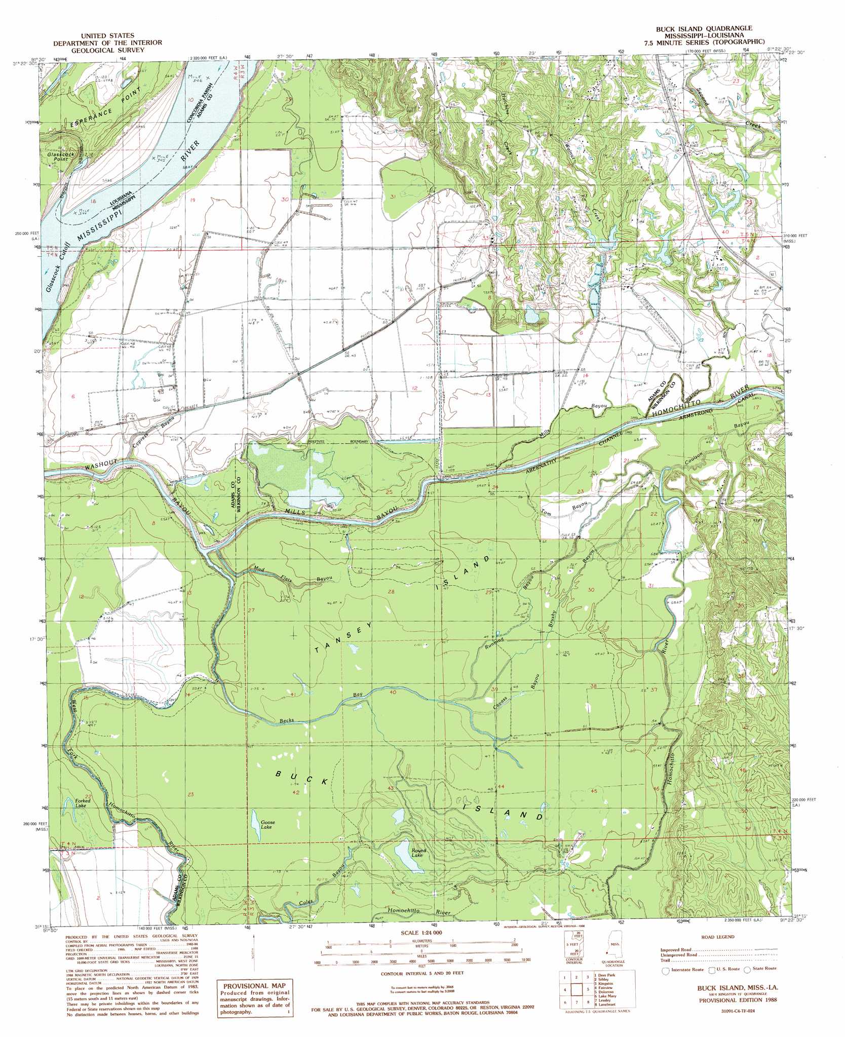
USGS Topo Quad 31091c4 - 1:24,000 scale
| Topo Map Name: | Buck Island |
| USGS Topo Quad ID: | 31091c4 |
| Print Size: | ca. 21 1/4" wide x 27" high |
| Southeast Coordinates: | 31.25° N latitude / 91.375° W longitude |
| Map Center Coordinates: | 31.3125° N latitude / 91.4375° W longitude |
| U.S. States: | MS, LA |
| Filename: | o31091c4.jpg |
| Download Map JPG Image: | Buck Island topo map 1:24,000 scale |
| Map Type: | Topographic |
| Topo Series: | 7.5´ |
| Map Scale: | 1:24,000 |
| Source of Map Images: | United States Geological Survey (USGS) |
| Alternate Map Versions: |
Buck Island MS 1988, updated 1988 Download PDF Buy paper map Buck Island MS 2012 Download PDF Buy paper map Buck Island MS 2015 Download PDF Buy paper map |
1:24,000 Topo Quads surrounding Buck Island
Frogmore |
Ferriday South |
Natchez |
Washington |
Cranfield |
Monterey |
Deer Park |
Sibley |
Kingston |
Jeannette |
Slocum |
Fairview |
Buck Island |
Doloroso |
Garden City |
Shaw |
Lake Mary |
Lessley |
Laneheart |
Wilkinson |
Turnbull Island |
Fort Adams |
Pinckneyville |
Woodville |
Newtonia |
> Back to 31091a1 at 1:100,000 scale
> Back to 31090a1 at 1:250,000 scale
> Back to U.S. Topo Maps home
Buck Island topo map: Gazetteer
Buck Island: Canals
Armstrong Canal elevation 17m 55′Buck Island: Channels
Abernathy Channel elevation 12m 39′Buck Island: Dams
Armstrong Lake Dam elevation 39m 127′D C Barksdale Lake Dam elevation 37m 121′
Hutchins Creek Dam elevation 23m 75′
Second Creek Watershed Structure One Dam elevation 31m 101′
T K Armstrong Catfish Ponds Dam elevation 21m 68′
Buck Island: Islands
Buck Island elevation 13m 42′Tansey Island elevation 13m 42′
Buck Island: Lakes
Forked Lake elevation 13m 42′Gaillards Lake elevation 15m 49′
Round Lake elevation 14m 45′
Buck Island: Oilfields
Buckhurst Oil Field elevation 45m 147′East Fairview Oil Field elevation 16m 52′
Ellis Lake Oil Field elevation 15m 49′
Gilliard Lake Oil Field elevation 16m 52′
Glasscock Oil Field elevation 16m 52′
Hutchins Landing Oil Field elevation 18m 59′
Lake Lucille Oil Field elevation 15m 49′
Mills Bayou Oil Field elevation 15m 49′
North Ellis Lake Oil Field elevation 15m 49′
North Lake Lucille Oil Field elevation 15m 49′
Rose Hill Oil Field elevation 46m 150′
Shieldsboro Oil Field elevation 19m 62′
Sibley Oil Field elevation 29m 95′
South Glen Aubin Oil Field elevation 47m 154′
Southeast Fairview Oil Field elevation 13m 42′
Washout Bayou Oil Field elevation 17m 55′
Buck Island: Streams
Becks Bay elevation 19m 62′Brushy Bayou elevation 12m 39′
Cavass Bayou elevation 12m 39′
Coles Bayou elevation 13m 42′
Coulson Bayou elevation 17m 55′
Cypress Bayou elevation 16m 52′
Hutchins Creek elevation 18m 59′
Mills Bayou elevation 9m 29′
Mud Flats Bayou elevation 11m 36′
Running Bayou elevation 13m 42′
Tom Bayou elevation 15m 49′
Walnut Creek elevation 17m 55′
Buck Island: Swamps
Goose Lake elevation 13m 42′Lake Lucile elevation 15m 49′
Buck Island digital topo map on disk
Buy this Buck Island topo map showing relief, roads, GPS coordinates and other geographical features, as a high-resolution digital map file on DVD: