Sibley Topo Map Mississippi
To zoom in, hover over the map of Sibley
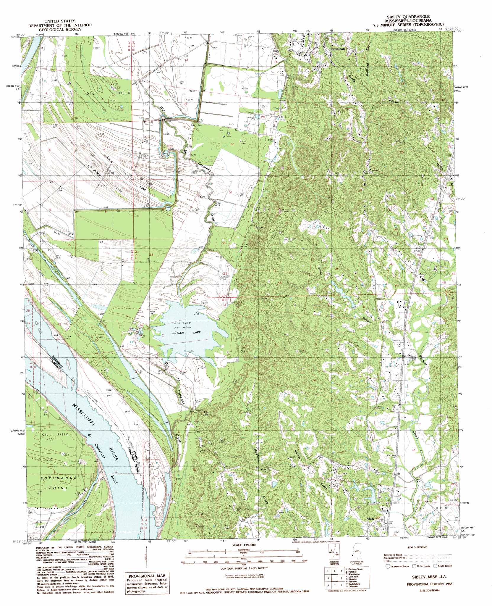
USGS Topo Quad 31091d4 - 1:24,000 scale
| Topo Map Name: | Sibley |
| USGS Topo Quad ID: | 31091d4 |
| Print Size: | ca. 21 1/4" wide x 27" high |
| Southeast Coordinates: | 31.375° N latitude / 91.375° W longitude |
| Map Center Coordinates: | 31.4375° N latitude / 91.4375° W longitude |
| U.S. States: | MS, LA |
| Filename: | o31091d4.jpg |
| Download Map JPG Image: | Sibley topo map 1:24,000 scale |
| Map Type: | Topographic |
| Topo Series: | 7.5´ |
| Map Scale: | 1:24,000 |
| Source of Map Images: | United States Geological Survey (USGS) |
| Alternate Map Versions: |
Sibley MS 1988, updated 1988 Download PDF Buy paper map Sibley MS 2012 Download PDF Buy paper map Sibley MS 2015 Download PDF Buy paper map |
1:24,000 Topo Quads surrounding Sibley
Dunbarton |
Ferriday North |
Spokane |
Pine Ridge |
Church Hill |
Frogmore |
Ferriday South |
Natchez |
Washington |
Cranfield |
Monterey |
Deer Park |
Sibley |
Kingston |
Jeannette |
Slocum |
Fairview |
Buck Island |
Doloroso |
Garden City |
Shaw |
Lake Mary |
Lessley |
Laneheart |
Wilkinson |
> Back to 31091a1 at 1:100,000 scale
> Back to 31090a1 at 1:250,000 scale
> Back to U.S. Topo Maps home
Sibley topo map: Gazetteer
Sibley: Bends
Saint Catherine Bend elevation 6m 19′Sibley: Cliffs
Ellis Cliffs elevation 59m 193′Sibley: Dams
Mrs Roland Stacy Lake Dam elevation 48m 157′Robbins Lake Dam elevation 62m 203′
Sibley: Lakes
Butler Lake elevation 12m 39′Long Lake elevation 14m 45′
Sibley: Oilfields
Anchorage Oil Field elevation 60m 196′Beverly Oil Field elevation 43m 141′
Bourbon Oil Field elevation 17m 55′
Butler Lake Oil Field elevation 16m 52′
Carthage Point Oil Field elevation 15m 49′
Cloverdale Oil Field elevation 19m 62′
Ellis Cliffs Oil Field elevation 55m 180′
Glen Aubin Oil Field elevation 62m 203′
Hilo Oil Field elevation 16m 52′
Ivanhoe Oil Field elevation 20m 65′
Laurel Hill Oil Field elevation 84m 275′
Long Lake Oil Field elevation 15m 49′
New Era Oil Field elevation 63m 206′
Ogden Bayou Oil Field elevation 74m 242′
Robbins Bayou Oil Field elevation 56m 183′
Southeast Woodlands Oil Field elevation 18m 59′
Willow Glen Oil Field elevation 16m 52′
Woodlands Oil Field elevation 18m 59′
Sibley: Populated Places
Cloverdale elevation 41m 134′Ellis Cliffs elevation 22m 72′
Esperance Landing elevation 6m 19′
Hutchins Landing elevation 10m 32′
Sibley elevation 49m 160′
Sibley: Streams
Old Saint Catherine Creek elevation 15m 49′Robins Bayou elevation 37m 121′
Sibley: Swamps
Willow Lake elevation 15m 49′Sibley digital topo map on disk
Buy this Sibley topo map showing relief, roads, GPS coordinates and other geographical features, as a high-resolution digital map file on DVD: