Washington Topo Map Mississippi
To zoom in, hover over the map of Washington
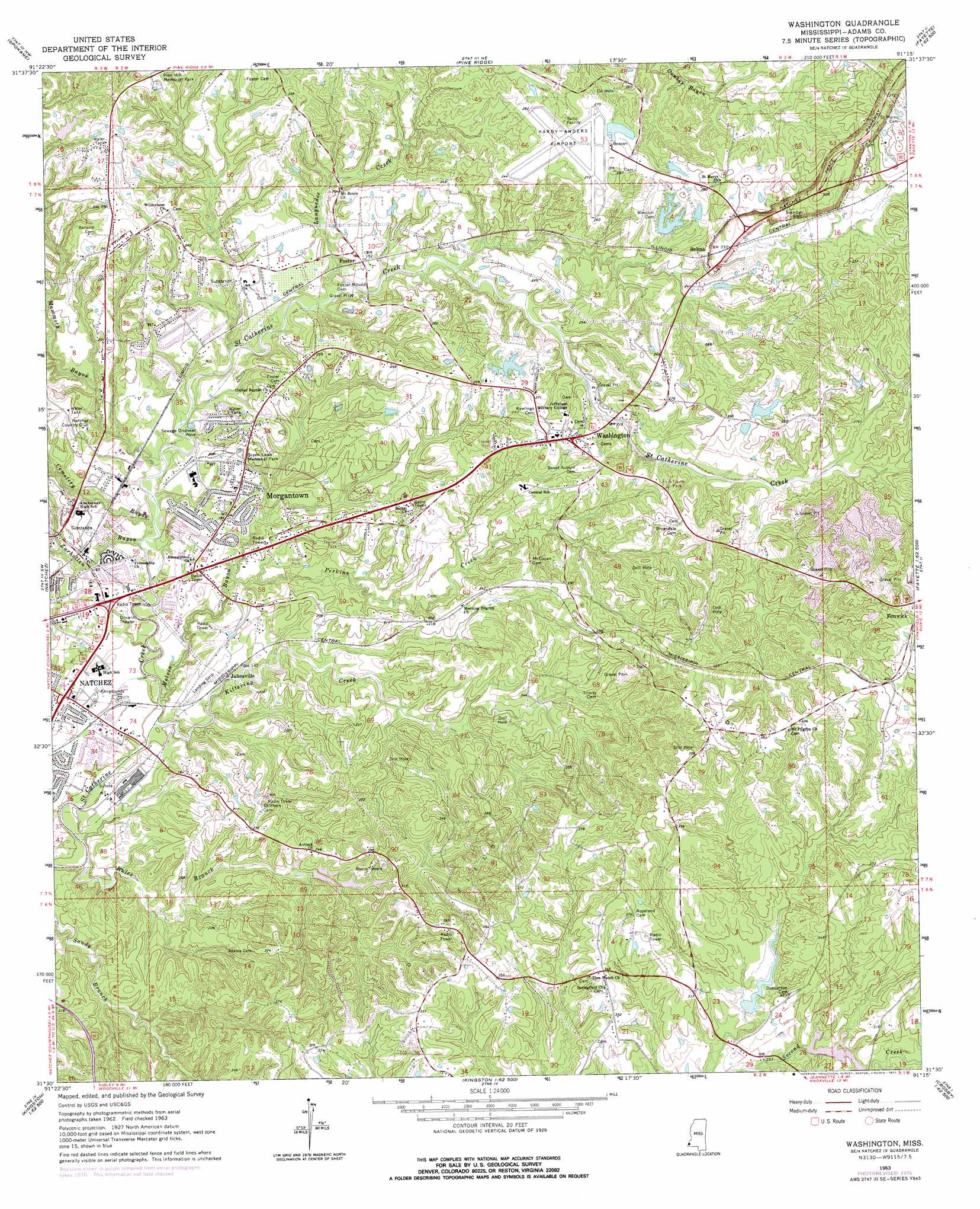
USGS Topo Quad 31091e3 - 1:24,000 scale
| Topo Map Name: | Washington |
| USGS Topo Quad ID: | 31091e3 |
| Print Size: | ca. 21 1/4" wide x 27" high |
| Southeast Coordinates: | 31.5° N latitude / 91.25° W longitude |
| Map Center Coordinates: | 31.5625° N latitude / 91.3125° W longitude |
| U.S. State: | MS |
| Filename: | o31091e3.jpg |
| Download Map JPG Image: | Washington topo map 1:24,000 scale |
| Map Type: | Topographic |
| Topo Series: | 7.5´ |
| Map Scale: | 1:24,000 |
| Source of Map Images: | United States Geological Survey (USGS) |
| Alternate Map Versions: |
Washington MS 1963, updated 1964 Download PDF Buy paper map Washington MS 1963, updated 1977 Download PDF Buy paper map Washington MS 2012 Download PDF Buy paper map Washington MS 2015 Download PDF Buy paper map |
1:24,000 Topo Quads surrounding Washington
Foules |
Waterproof |
Chamblee |
Rodney |
Lorman |
Ferriday North |
Spokane |
Pine Ridge |
Church Hill |
Fayette |
Ferriday South |
Natchez |
Washington |
Cranfield |
Roxie |
Deer Park |
Sibley |
Kingston |
Jeannette |
Knoxville |
Fairview |
Buck Island |
Doloroso |
Garden City |
Crosby |
> Back to 31091e1 at 1:100,000 scale
> Back to 31090a1 at 1:250,000 scale
> Back to U.S. Topo Maps home
Washington topo map: Gazetteer
Washington: Airports
Hardy-Anders Field Natchez-Adams County Airport elevation 81m 265′Washington: Dams
Callon Lake Dam elevation 67m 219′Callon Lake Dam elevation 77m 252′
Callon Lake Dam elevation 85m 278′
Junkin Gravel Company Lake Dam elevation 90m 295′
Kaiser-Carlton Lake Dam elevation 85m 278′
Risher Lake Dam elevation 80m 262′
Second Creek Watershed Structure 6a Dam elevation 77m 252′
Second Creek Watershed Structure 6b Dam elevation 92m 301′
Tully Seale Lake Dam elevation 71m 232′
Washington: Oilfields
Grafton Oil Field elevation 75m 246′Lagrange Oil Field elevation 79m 259′
Mistletoe Oil Field elevation 80m 262′
Morgantown Oil Field elevation 76m 249′
North Lagrange Oil Field elevation 99m 324′
Pleasant Hill Oil Field elevation 63m 206′
Springfield Oil Field elevation 87m 285′
Washington: Parks
Natchez Trace Parkway elevation 87m 285′Washington: Populated Places
Foster elevation 55m 180′Johnsville elevation 43m 141′
Morgantown elevation 59m 193′
Saint Catherine elevation 37m 121′
Selma elevation 73m 239′
Washington elevation 85m 278′
Washington: Streams
Cemetery Bayou elevation 35m 114′Kittering Creek elevation 25m 82′
Languedoc Creek elevation 37m 121′
Mammoth Bayou elevation 32m 104′
Melvin Bayou elevation 25m 82′
Perkins Creek elevation 33m 108′
Rules Branch elevation 24m 78′
Zurhellen Bayou elevation 30m 98′
Washington: Summits
Foster Mounds elevation 56m 183′Washington digital topo map on disk
Buy this Washington topo map showing relief, roads, GPS coordinates and other geographical features, as a high-resolution digital map file on DVD: