Natchez Topo Map Mississippi
To zoom in, hover over the map of Natchez
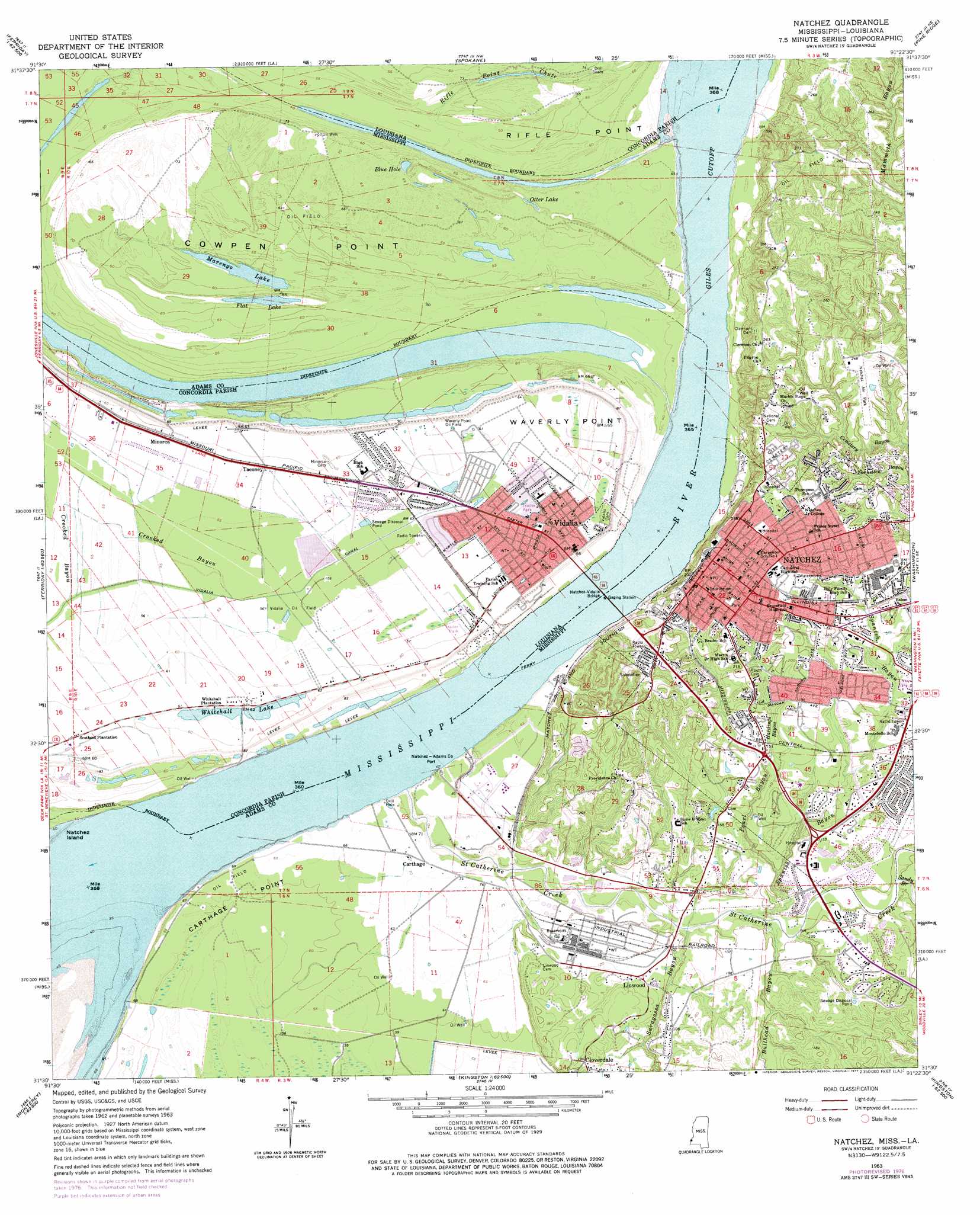
USGS Topo Quad 31091e4 - 1:24,000 scale
| Topo Map Name: | Natchez |
| USGS Topo Quad ID: | 31091e4 |
| Print Size: | ca. 21 1/4" wide x 27" high |
| Southeast Coordinates: | 31.5° N latitude / 91.375° W longitude |
| Map Center Coordinates: | 31.5625° N latitude / 91.4375° W longitude |
| U.S. States: | MS, LA |
| Filename: | o31091e4.jpg |
| Download Map JPG Image: | Natchez topo map 1:24,000 scale |
| Map Type: | Topographic |
| Topo Series: | 7.5´ |
| Map Scale: | 1:24,000 |
| Source of Map Images: | United States Geological Survey (USGS) |
| Alternate Map Versions: |
Vidalia MS 1909 Download PDF Buy paper map Natchez MS 1963, updated 1964 Download PDF Buy paper map Natchez MS 1963, updated 1972 Download PDF Buy paper map Natchez MS 1963, updated 1977 Download PDF Buy paper map Natchez MS 2012 Download PDF Buy paper map Natchez MS 2015 Download PDF Buy paper map |
1:24,000 Topo Quads surrounding Natchez
Sicily Island |
Foules |
Waterproof |
Chamblee |
Rodney |
Dunbarton |
Ferriday North |
Spokane |
Pine Ridge |
Church Hill |
Frogmore |
Ferriday South |
Natchez |
Washington |
Cranfield |
Monterey |
Deer Park |
Sibley |
Kingston |
Jeannette |
Slocum |
Fairview |
Buck Island |
Doloroso |
Garden City |
> Back to 31091e1 at 1:100,000 scale
> Back to 31090a1 at 1:250,000 scale
> Back to U.S. Topo Maps home
Natchez topo map: Gazetteer
Natchez: Bars
Carthage Upper Bar elevation 8m 26′Natchez Island Bar elevation 9m 29′
Natchez: Bends
Giles Bend elevation 7m 22′Giles Bend elevation 8m 26′
Natchez: Bridges
Natchez-Vidalia Bridge elevation 8m 26′Natchez-Vidalia Bridge elevation 8m 26′
Natchez: Canals
Vidalia Canal elevation 15m 49′Natchez: Capes
Carthage Point elevation 18m 59′Cowpen Point elevation 22m 72′
Rifle Point elevation 17m 55′
Waverly Point elevation 19m 62′
Natchez: Channels
Giles Cutoff elevation 8m 26′Natchez: Crossings
Vidalia Ferry elevation 6m 19′Natchez: Guts
Crooked Bayou elevation 17m 55′Rifle Point Chute elevation 18m 59′
Natchez: Lakes
Blue Hole elevation 17m 55′Flat Lake elevation 14m 45′
Marengo Lake elevation 16m 52′
Otter Lake elevation 14m 45′
Whitehall Lake elevation 16m 52′
Natchez: Levees
Carthage Revetment elevation 12m 39′Natchez Front Revetment elevation 6m 19′
Natchez Island Revetment (historical) elevation 9m 29′
Natchez: Oilfields
Belwood Oil Field elevation 24m 78′Cowpen Point Oil Field elevation 18m 59′
East Carthage Point Oil Field elevation 18m 59′
Flat Lake Oil Field elevation 16m 52′
Gardens Oil Field elevation 64m 209′
Giles Bend Oil Field elevation 23m 75′
Homewood Oil Field elevation 67m 219′
Linwood Oil Field elevation 44m 144′
Majorca Oil Field elevation 51m 167′
Natchez Ferry Oil Field elevation 21m 68′
Natchez Island Gas Field elevation 18m 59′
North Carthage Point Oil Field elevation 20m 65′
North Cowpen Point Oil Field elevation 20m 65′
North Gardens Oil Field elevation 69m 226′
North Natchez Oil Field elevation 62m 203′
Otter Lake Oil Field elevation 17m 55′
Vidalia Oil Field elevation 15m 49′
Waverly Point Oil Field elevation 20m 65′
West Carthage Point Oil Field elevation 20m 65′
Natchez: Parks
Natchez National Historical Park elevation 51m 167′Natchez: Populated Places
Carthage elevation 22m 72′Hawthorne elevation 56m 183′
Linwood elevation 36m 118′
Minorca elevation 20m 65′
Natchez elevation 66m 216′
Natchez Under the Hill (historical) elevation 5m 16′
Scotland (historical) elevation 18m 59′
Taconey elevation 18m 59′
Vidalia elevation 21m 68′
White Hall (historical) elevation 18m 59′
Natchez: Post Offices
Natchez Post Office elevation 64m 209′Vidalia Post Office elevation 19m 62′
Natchez: Streams
Bullhead Bayou elevation 19m 62′Hardings Bayou elevation 30m 98′
Pearl Bayou elevation 22m 72′
Saint Catherine Creek elevation 10m 32′
Sandy Branch elevation 21m 68′
Saragossa Bayou elevation 17m 55′
Spanish Bayou elevation 19m 62′
Natchez: Summits
Fatherland Mounds elevation 33m 108′Natchez digital topo map on disk
Buy this Natchez topo map showing relief, roads, GPS coordinates and other geographical features, as a high-resolution digital map file on DVD: