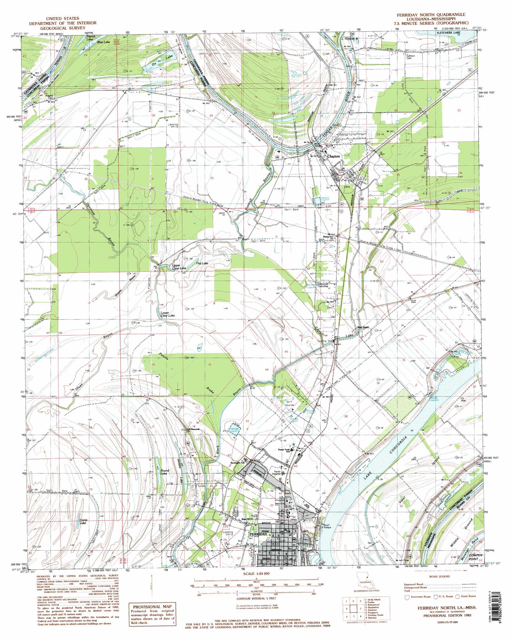
Ferriday North Topo Map Louisiana
To zoom in, hover over the map of Ferriday North
USGS Topo Quad 31091f5 - 1:24,000 scale
| Topo Map Name: | Ferriday North |
| USGS Topo Quad ID: | 31091f5 |
| Print Size: | ca. 21 1/4" wide x 27" high |
| Southeast Coordinates: | 31.625° N latitude / 91.5° W longitude |
| Map Center Coordinates: | 31.6875° N latitude / 91.5625° W longitude |
| U.S. States: | LA, MS |
| Filename: | o31091f5.jpg |
| Download Map JPG Image: | Ferriday North topo map 1:24,000 scale |
| Map Type: | Topographic |
| Topo Series: | 7.5´ |
| Map Scale: | 1:24,000 |
| Source of Map Images: | United States Geological Survey (USGS) |
| Alternate Map Versions: |
Ferriday North LA 1983, updated 1984 Download PDF Buy paper map Ferriday North LA 1983, updated 1984 Download PDF Buy paper map Ferriday North LA 1995, updated 1997 Download PDF Buy paper map Ferriday North LA 1999, updated 2000 Download PDF Buy paper map Ferriday North LA 2012 Download PDF Buy paper map Ferriday North LA 2015 Download PDF Buy paper map |
1:24,000 Topo Quads surrounding Ferriday North
Extension |
Wisner |
Oakley |
Gretna Green |
Lake Bruin |
Harrisonburg |
Sicily Island |
Foules |
Waterproof |
Chamblee |
Jonesville North |
Dunbarton |
Ferriday North |
Spokane |
Pine Ridge |
Jonesville South |
Frogmore |
Ferriday South |
Natchez |
Washington |
Mayna |
Monterey |
Deer Park |
Sibley |
Kingston |
> Back to 31091e1 at 1:100,000 scale
> Back to 31090a1 at 1:250,000 scale
> Back to U.S. Topo Maps home
Ferriday North topo map: Gazetteer
Ferriday North: Airports
Dunns Airport elevation 17m 55′Ferriday North: Guts
Black Bayou elevation 13m 42′Carroll Lake elevation 15m 49′
Dicen Bayou elevation 13m 42′
Kimball Bayou elevation 15m 49′
Opossum Bayou elevation 16m 52′
Shavins Bayou elevation 15m 49′
Ferriday North: Islands
Middle Ground elevation 20m 65′Vidal Island elevation 20m 65′
Ferriday North: Lakes
Blue Lake elevation 17m 55′Camp Lake elevation 13m 42′
Flat Lake elevation 14m 45′
Fletchers Lake elevation 13m 42′
Jenkins Lake elevation 15m 49′
Lake Concordia elevation 15m 49′
Lower Clear Lake elevation 14m 45′
Ox Lake elevation 16m 52′
Round Lake elevation 15m 49′
Shavins Lake elevation 17m 55′
Upper Clear Lake elevation 14m 45′
Ferriday North: Oilfields
Vidal Island Oil Field elevation 15m 49′Ferriday North: Parks
Learned Park elevation 17m 55′Ferriday North: Populated Places
Clayton elevation 17m 55′Ferriday elevation 16m 52′
Red Gum elevation 17m 55′
West Ferriday elevation 16m 52′
Ferriday North: Post Offices
Ferriday Post Office elevation 16m 52′Ferriday North: Streams
Little Tensas River elevation 11m 36′Ferriday North: Swamps
Panola Brake elevation 13m 42′Ferriday North digital topo map on disk
Buy this Ferriday North topo map showing relief, roads, GPS coordinates and other geographical features, as a high-resolution digital map file on DVD: