Jonesville North Topo Map Louisiana
To zoom in, hover over the map of Jonesville North
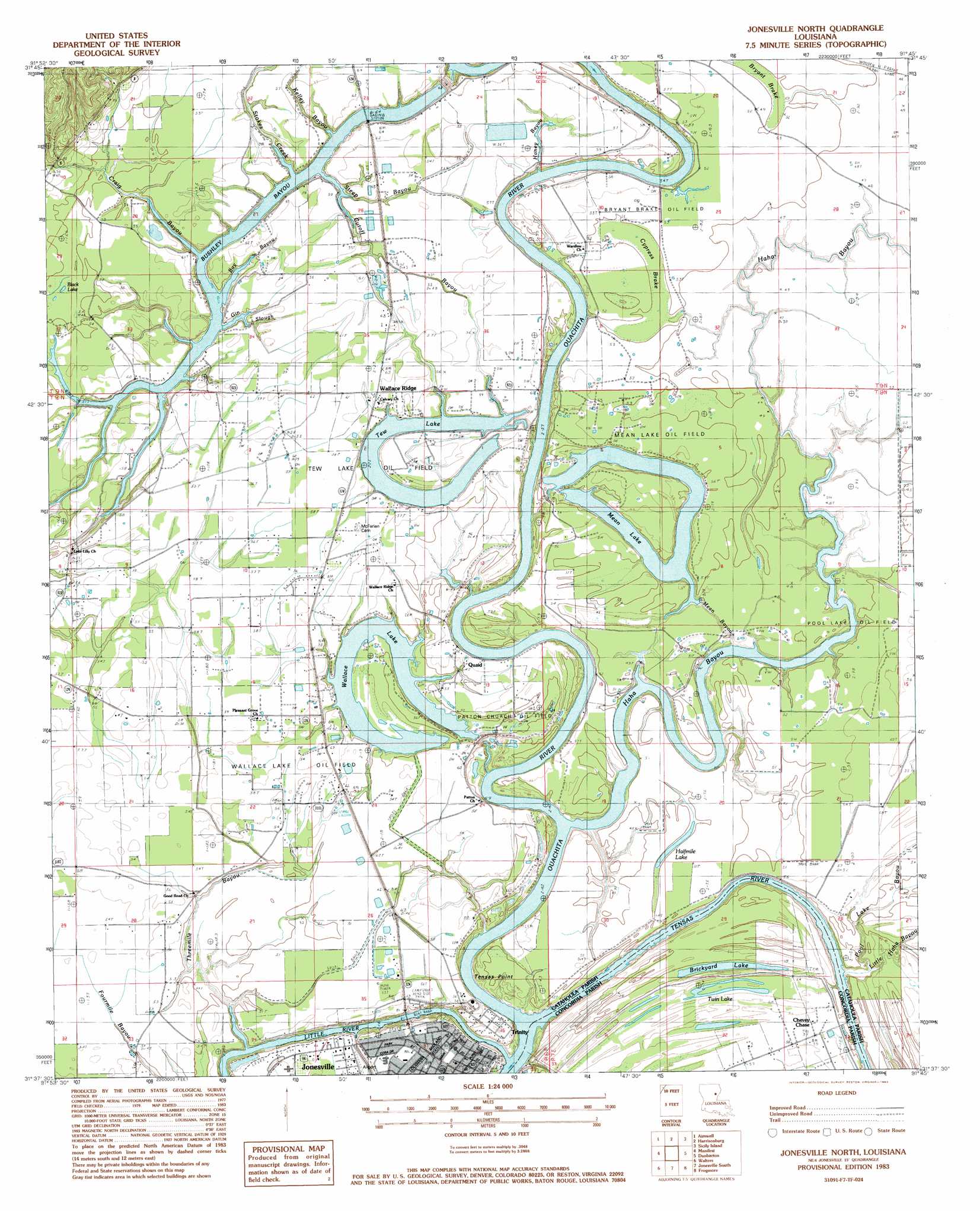
USGS Topo Quad 31091f7 - 1:24,000 scale
| Topo Map Name: | Jonesville North |
| USGS Topo Quad ID: | 31091f7 |
| Print Size: | ca. 21 1/4" wide x 27" high |
| Southeast Coordinates: | 31.625° N latitude / 91.75° W longitude |
| Map Center Coordinates: | 31.6875° N latitude / 91.8125° W longitude |
| U.S. State: | LA |
| Filename: | o31091f7.jpg |
| Download Map JPG Image: | Jonesville North topo map 1:24,000 scale |
| Map Type: | Topographic |
| Topo Series: | 7.5´ |
| Map Scale: | 1:24,000 |
| Source of Map Images: | United States Geological Survey (USGS) |
| Alternate Map Versions: |
Jonesville North LA 1983, updated 1983 Download PDF Buy paper map Jonesville North LA 2012 Download PDF Buy paper map Jonesville North LA 2015 Download PDF Buy paper map |
1:24,000 Topo Quads surrounding Jonesville North
Holum |
Enterprise |
Extension |
Wisner |
Oakley |
Nickel |
Aimwell |
Harrisonburg |
Sicily Island |
Foules |
Jena East |
Manifest |
Jonesville North |
Dunbarton |
Ferriday North |
Bird Island Point |
Walters |
Jonesville South |
Frogmore |
Ferriday South |
Buckeye Ne |
Larto Lake North |
Mayna |
Monterey |
Deer Park |
> Back to 31091e1 at 1:100,000 scale
> Back to 31090a1 at 1:250,000 scale
> Back to U.S. Topo Maps home
Jonesville North topo map: Gazetteer
Jonesville North: Airports
Jonesville Airport elevation 16m 52′Jonesville North: Capes
Tensas Point elevation 16m 52′Jonesville North: Guts
Cutoff Bayou elevation 16m 52′Mean Bayou elevation 12m 39′
Jonesville North: Lakes
Black Lake elevation 15m 49′Brickyard Lake elevation 14m 45′
Halfmile Lake elevation 15m 49′
Mean Lake elevation 11m 36′
Tew Lake elevation 14m 45′
Twin Lake elevation 16m 52′
Wallace Lake elevation 13m 42′
Jonesville North: Oilfields
Brickyard Lake Oil Field elevation 16m 52′Bryant Brake Oil Field elevation 16m 52′
Mean Lake Oil Field elevation 15m 49′
Patton Church Oil Field elevation 15m 49′
Pool Lake Oil Field elevation 16m 52′
Tew Lake Oil Field elevation 17m 55′
Tew Lake Oil Field elevation 16m 52′
Wallace Lake Oil Field elevation 17m 55′
Jonesville North: Populated Places
Black River (historical) elevation 17m 55′Chevey Chase elevation 17m 55′
Jonesville elevation 18m 59′
Quaid elevation 17m 55′
Trinity elevation 18m 59′
Wallace Ridge elevation 18m 59′
Jonesville North: Streams
Bay Bayou elevation 13m 42′Bushley Bayou elevation 10m 32′
Craig Bayou elevation 13m 42′
Gin Slough elevation 13m 42′
Haha Bayou elevation 9m 29′
Honey Bayou elevation 12m 39′
Kelley Bayou elevation 13m 42′
Little River elevation 9m 29′
Ouachita River elevation 9m 29′
Steep Bayou elevation 13m 42′
Stokes Creek elevation 13m 42′
Tensas River elevation 9m 29′
Threemile Bayou elevation 12m 39′
Jonesville North: Swamps
Bryant Brake elevation 15m 49′Cypress Brake elevation 15m 49′
Jonesville North digital topo map on disk
Buy this Jonesville North topo map showing relief, roads, GPS coordinates and other geographical features, as a high-resolution digital map file on DVD: