Oakley Topo Map Louisiana
To zoom in, hover over the map of Oakley
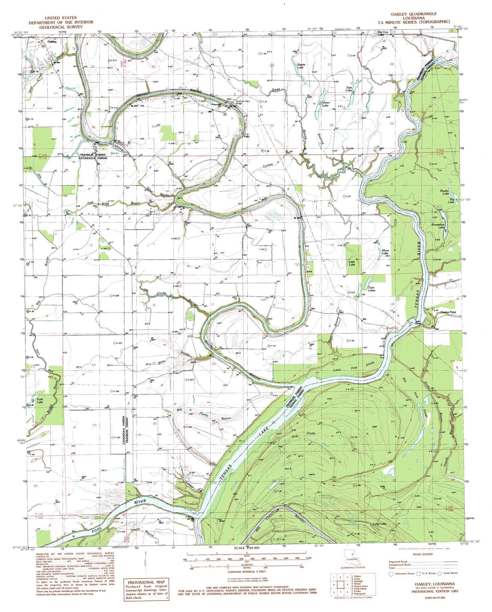
USGS Topo Quad 31091h5 - 1:24,000 scale
| Topo Map Name: | Oakley |
| USGS Topo Quad ID: | 31091h5 |
| Print Size: | ca. 21 1/4" wide x 27" high |
| Southeast Coordinates: | 31.875° N latitude / 91.5° W longitude |
| Map Center Coordinates: | 31.9375° N latitude / 91.5625° W longitude |
| U.S. State: | LA |
| Filename: | o31091h5.jpg |
| Download Map JPG Image: | Oakley topo map 1:24,000 scale |
| Map Type: | Topographic |
| Topo Series: | 7.5´ |
| Map Scale: | 1:24,000 |
| Source of Map Images: | United States Geological Survey (USGS) |
| Alternate Map Versions: |
Oakley LA 1983, updated 1984 Download PDF Buy paper map Oakley LA 2012 Download PDF Buy paper map Oakley LA 2015 Download PDF Buy paper map |
1:24,000 Topo Quads surrounding Oakley
Liddieville |
Winnsboro |
Crowville |
Tensas Bluff |
Westwood |
Fort Necessity |
Gilbert |
Como |
Newlight |
Saranac |
Extension |
Wisner |
Oakley |
Gretna Green |
Lake Bruin |
Harrisonburg |
Sicily Island |
Foules |
Waterproof |
Chamblee |
Jonesville North |
Dunbarton |
Ferriday North |
Spokane |
Pine Ridge |
> Back to 31091e1 at 1:100,000 scale
> Back to 31090a1 at 1:250,000 scale
> Back to U.S. Topo Maps home
Oakley topo map: Gazetteer
Oakley: Bends
Deer Creek Cutoff elevation 18m 59′Oakley: Bridges
Kendrick Ferry Bridge elevation 11m 36′Oakley: Capes
Cooter Point elevation 11m 36′Oakley: Flats
Hog Glade elevation 18m 59′Oakley: Guts
Big Bayou elevation 17m 55′Black Bayou elevation 16m 52′
Clarks Bayou elevation 16m 52′
Deep Bayou elevation 17m 55′
Fish Bayou elevation 18m 59′
Gin Bayou elevation 19m 62′
Glade Bayou elevation 11m 36′
Hayes Bayou elevation 18m 59′
Luster Bayou elevation 12m 39′
Oak Bluff Bayou elevation 17m 55′
Wolf Bayou elevation 18m 59′
Oakley: Lakes
Batese Lake elevation 17m 55′Big Lake elevation 16m 52′
Brushy Lake elevation 17m 55′
East Lake elevation 16m 52′
Green Lake elevation 16m 52′
Horseshoe Lake elevation 14m 45′
Little Lake elevation 18m 59′
Moon Lake elevation 17m 55′
Tensas Lake elevation 11m 36′
Twin Lakes elevation 16m 52′
York Lake elevation 16m 52′
Oakley: Populated Places
Big A Plenty Landing elevation 19m 62′Cooters Landing elevation 14m 45′
Craig Landing elevation 20m 65′
Cut Off Landing elevation 20m 65′
Oakley elevation 23m 75′
Oakley: Streams
Bayou Macon elevation 11m 36′Bens Bayou elevation 13m 42′
Big a Plenty Bayou elevation 12m 39′
Dean Bayou elevation 11m 36′
Fool River elevation 11m 36′
Lighting Bayou elevation 11m 36′
Otter Bayou elevation 14m 45′
Roaring Bayou elevation 11m 36′
Turkey Bayou elevation 13m 42′
Oakley: Swamps
Big Hog Glade elevation 11m 36′Little Hog Glade elevation 11m 36′
Long Lake elevation 15m 49′
Oakley digital topo map on disk
Buy this Oakley topo map showing relief, roads, GPS coordinates and other geographical features, as a high-resolution digital map file on DVD: