Lecompte Topo Map Louisiana
To zoom in, hover over the map of Lecompte
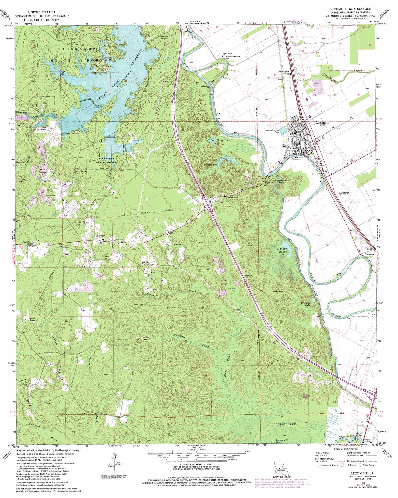
USGS Topo Quad 31092a4 - 1:24,000 scale
| Topo Map Name: | Lecompte |
| USGS Topo Quad ID: | 31092a4 |
| Print Size: | ca. 21 1/4" wide x 27" high |
| Southeast Coordinates: | 31° N latitude / 92.375° W longitude |
| Map Center Coordinates: | 31.0625° N latitude / 92.4375° W longitude |
| U.S. State: | LA |
| Filename: | o31092a4.jpg |
| Download Map JPG Image: | Lecompte topo map 1:24,000 scale |
| Map Type: | Topographic |
| Topo Series: | 7.5´ |
| Map Scale: | 1:24,000 |
| Source of Map Images: | United States Geological Survey (USGS) |
| Alternate Map Versions: |
Lecompte LA 1972, updated 1974 Download PDF Buy paper map Lecompte LA 1972, updated 1979 Download PDF Buy paper map Lecompte LA 1972, updated 1992 Download PDF Buy paper map Lecompte LA 2012 Download PDF Buy paper map Lecompte LA 2015 Download PDF Buy paper map |
1:24,000 Topo Quads surrounding Lecompte
Gardner |
Rapides |
Alexandria |
Libuse |
Buckeye |
Elmer |
Woodworth West |
Woodworth East |
Latanier |
Effie |
Melder |
Forest Hill |
Lecompte |
Cheneyville |
Belle D'Eau |
Pawnee |
Glenmora |
Cocodrie Lake |
Lone Pine |
Bunkie |
Oakdale |
Beaver |
Pine Prairie |
Saint Landry |
Whiteville |
> Back to 31092a1 at 1:100,000 scale
> Back to 31092a1 at 1:250,000 scale
> Back to U.S. Topo Maps home
Lecompte topo map: Gazetteer
Lecompte: Dams
Bayou Cocodrie Dam elevation 17m 55′Lecompte: Forests
Alexander State Forest elevation 34m 111′Lecompte: Lakes
Freeman Lake elevation 22m 72′Hardy Lake elevation 21m 68′
Mathews Brake elevation 21m 68′
Weems Lake elevation 21m 68′
Lecompte: Populated Places
Hobson (historical) elevation 29m 95′Lecompte elevation 21m 68′
Meeker elevation 22m 72′
Midway elevation 49m 160′
Sartori (historical) elevation 21m 68′
Lecompte: Reservoirs
Indian Creek Reservoir elevation 26m 85′Lecompte: Streams
Beaver Creek elevation 19m 62′Burgess Creek elevation 27m 88′
Carr Creek elevation 20m 65′
Carrs Creek elevation 26m 85′
Cheney Creek elevation 25m 82′
Chinquapin Creek elevation 26m 85′
Cockrell Creek elevation 18m 59′
Indian Creek elevation 26m 85′
Marshall Creek elevation 16m 52′
Soap Creek elevation 23m 75′
Lecompte: Swamps
Beaver Creek Swamp elevation 17m 55′Lecompte digital topo map on disk
Buy this Lecompte topo map showing relief, roads, GPS coordinates and other geographical features, as a high-resolution digital map file on DVD: