Marksville North Topo Map Louisiana
To zoom in, hover over the map of Marksville North
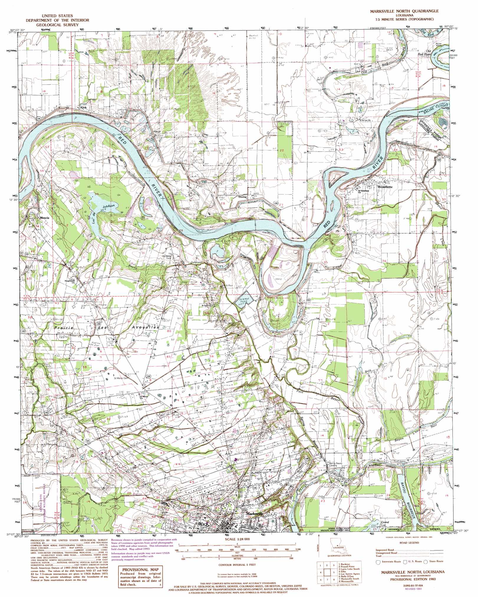
USGS Topo Quad 31092b1 - 1:24,000 scale
| Topo Map Name: | Marksville North |
| USGS Topo Quad ID: | 31092b1 |
| Print Size: | ca. 21 1/4" wide x 27" high |
| Southeast Coordinates: | 31.125° N latitude / 92° W longitude |
| Map Center Coordinates: | 31.1875° N latitude / 92.0625° W longitude |
| U.S. State: | LA |
| Filename: | o31092b1.jpg |
| Download Map JPG Image: | Marksville North topo map 1:24,000 scale |
| Map Type: | Topographic |
| Topo Series: | 7.5´ |
| Map Scale: | 1:24,000 |
| Source of Map Images: | United States Geological Survey (USGS) |
| Alternate Map Versions: |
Marksville North LA 1983, updated 1983 Download PDF Buy paper map Marksville North LA 1983, updated 1984 Download PDF Buy paper map Marksville North LA 1983, updated 1993 Download PDF Buy paper map Marksville North LA 2012 Download PDF Buy paper map Marksville North LA 2015 Download PDF Buy paper map |
1:24,000 Topo Quads surrounding Marksville North
Green Gables |
Holloway |
Buckeye Ne |
Larto Lake North |
Mayna |
Libuse |
Buckeye |
Powell Point |
Larto Lake South |
Acme |
Latanier |
Effie |
Marksville North |
Lac Sainte Agnes |
Ile Natchitoches |
Cheneyville |
Belle D'Eau |
Marksville South |
Moreauville |
Big Bend |
Lone Pine |
Bunkie |
Cottonport |
Plaucheville |
Simmesport |
> Back to 31092a1 at 1:100,000 scale
> Back to 31092a1 at 1:250,000 scale
> Back to U.S. Topo Maps home
Marksville North topo map: Gazetteer
Marksville North: Airports
Humana Hospital Heliport elevation 25m 82′Marksville North: Channels
Saline Cutoff elevation 12m 39′Marksville North: Flats
Prairie des Avoyelles elevation 22m 72′Marksville North: Lakes
Bayou Bourbeux elevation 13m 42′Heifer Lake (historical) elevation 15m 49′
Lac Bois Sec elevation 13m 42′
Lac de Johnson elevation 17m 55′
Marksville North: Oilfields
Marksville Oil Field elevation 23m 75′Marksville Townsite Oil Field elevation 23m 75′
South Vick Oil Field elevation 15m 49′
Marksville North: Populated Places
Belleville elevation 22m 72′Brouillette elevation 17m 55′
Dunlap elevation 17m 55′
Marksville elevation 25m 82′
Moncla elevation 23m 75′
Montcla elevation 22m 72′
Spring Bayou Landing elevation 13m 42′
Vick elevation 19m 62′
Marksville North: Post Offices
Marksville Post Office elevation 25m 82′Vick Post Office elevation 18m 59′
Marksville North: Streams
Bayou Johnson elevation 14m 45′Bayou L'Eau Noire elevation 14m 45′
Petit Bayou Rouge elevation 14m 45′
Spring Bayou elevation 13m 42′
Marksville North digital topo map on disk
Buy this Marksville North topo map showing relief, roads, GPS coordinates and other geographical features, as a high-resolution digital map file on DVD: