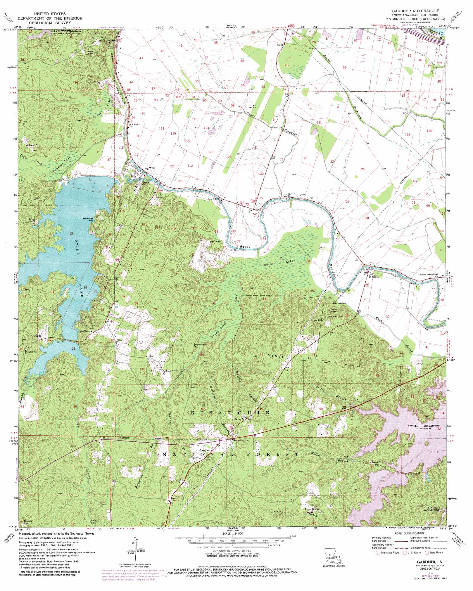
Gardner Topo Map Louisiana
To zoom in, hover over the map of Gardner
USGS Topo Quad 31092c6 - 1:24,000 scale
| Topo Map Name: | Gardner |
| USGS Topo Quad ID: | 31092c6 |
| Print Size: | ca. 21 1/4" wide x 27" high |
| Southeast Coordinates: | 31.25° N latitude / 92.625° W longitude |
| Map Center Coordinates: | 31.3125° N latitude / 92.6875° W longitude |
| U.S. State: | LA |
| Filename: | o31092c6.jpg |
| Download Map JPG Image: | Gardner topo map 1:24,000 scale |
| Map Type: | Topographic |
| Topo Series: | 7.5´ |
| Map Scale: | 1:24,000 |
| Source of Map Images: | United States Geological Survey (USGS) |
| Alternate Map Versions: |
Gardner LA 1971, updated 1974 Download PDF Buy paper map Gardner LA 1971, updated 1984 Download PDF Buy paper map Gardner LA 1971, updated 1992 Download PDF Buy paper map Gardner LA 2003, updated 2005 Download PDF Buy paper map Gardner LA 2012 Download PDF Buy paper map Gardner LA 2015 Download PDF Buy paper map |
| FStopo: | US Forest Service topo Gardner is available: Download FStopo PDF Download FStopo TIF |
1:24,000 Topo Quads surrounding Gardner
Cloutierville |
Aloha |
Colfax |
Dry Prong |
Pollock |
Gorum |
Lena |
Boyce |
Rock Hill |
Ball |
Temple |
Jericho |
Gardner |
Rapides |
Alexandria |
Lacamp |
Sieper |
Elmer |
Woodworth West |
Woodworth East |
Fullerton Lake |
Afeman |
Melder |
Forest Hill |
Lecompte |
> Back to 31092a1 at 1:100,000 scale
> Back to 31092a1 at 1:250,000 scale
> Back to U.S. Topo Maps home
Gardner topo map: Gazetteer
Gardner: Dams
Cotile Lake Dam elevation 28m 91′Gardner: Lakes
Flag Lake (historical) elevation 25m 82′Gardner: Parks
Kincaid Recreation Area elevation 38m 124′McNutt Rural Historic District elevation 27m 88′
Gardner: Populated Places
Crane elevation 27m 88′Gardner elevation 56m 183′
Hot Wells elevation 25m 82′
McNutt elevation 27m 88′
Milford (historical) elevation 54m 177′
Quadrate elevation 28m 91′
Wilda elevation 38m 124′
Gardner: Post Offices
Gardner Post Office elevation 49m 160′Gardner: Reservoirs
Cotile Lake elevation 28m 91′Gardner: Streams
Alligator Slough elevation 23m 75′Bayou Cocodrie elevation 24m 78′
Brown Creek elevation 28m 91′
Burney Branch elevation 31m 101′
Dyer Creek elevation 31m 101′
Hemphill Creek elevation 31m 101′
Indian Creek elevation 33m 108′
Jacks Creek elevation 25m 82′
Patterson Branch elevation 34m 111′
Sibley Branch elevation 28m 91′
Walker Branch elevation 28m 91′
Whitley Branch elevation 29m 95′
Williamson Branch elevation 28m 91′
Gardner: Summits
McNutt Hill elevation 56m 183′Gardner: Swamps
Brown Creek Lake elevation 27m 88′Crane Lake elevation 25m 82′
Gourney Lake elevation 25m 82′
Hunter Lake elevation 25m 82′
Gardner digital topo map on disk
Buy this Gardner topo map showing relief, roads, GPS coordinates and other geographical features, as a high-resolution digital map file on DVD: