Fishville Topo Map Louisiana
To zoom in, hover over the map of Fishville
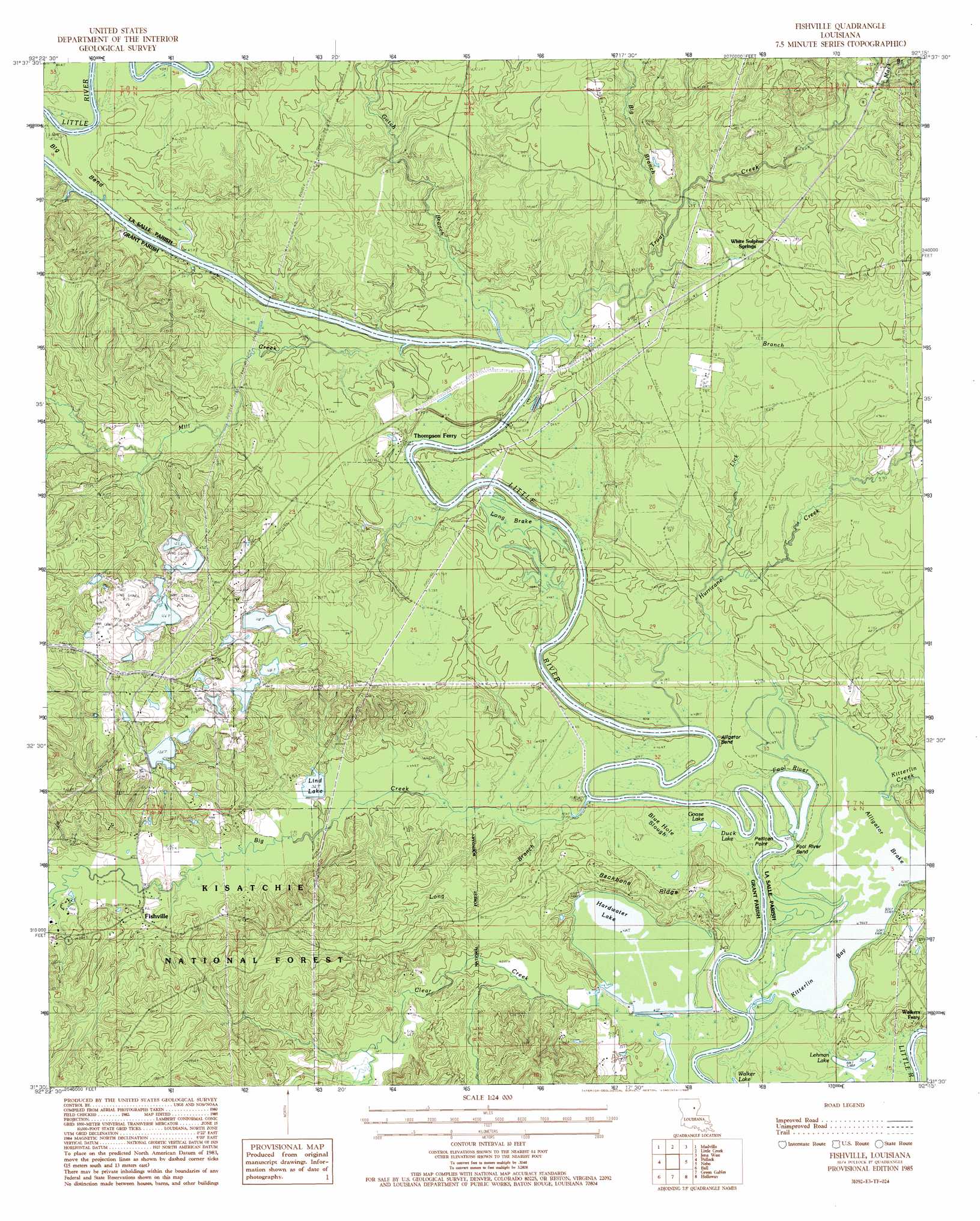
USGS Topo Quad 31092e3 - 1:24,000 scale
| Topo Map Name: | Fishville |
| USGS Topo Quad ID: | 31092e3 |
| Print Size: | ca. 21 1/4" wide x 27" high |
| Southeast Coordinates: | 31.5° N latitude / 92.25° W longitude |
| Map Center Coordinates: | 31.5625° N latitude / 92.3125° W longitude |
| U.S. State: | LA |
| Filename: | o31092e3.jpg |
| Download Map JPG Image: | Fishville topo map 1:24,000 scale |
| Map Type: | Topographic |
| Topo Series: | 7.5´ |
| Map Scale: | 1:24,000 |
| Source of Map Images: | United States Geological Survey (USGS) |
| Alternate Map Versions: |
Fishville LA 1985, updated 1985 Download PDF Buy paper map Fishville LA 2003, updated 2005 Download PDF Buy paper map Fishville LA 2012 Download PDF Buy paper map Fishville LA 2015 Download PDF Buy paper map |
| FStopo: | US Forest Service topo Fishville is available: Download FStopo PDF Download FStopo TIF |
1:24,000 Topo Quads surrounding Fishville
Packton |
Georgetown |
Tullas |
Summerville |
Nickel |
Williana |
Mudville |
Little Creek |
Jena West |
Jena East |
Dry Prong |
Pollock |
Fishville |
Nebo |
Bird Island Point |
Rock Hill |
Ball |
Green Gables |
Holloway |
Buckeye Ne |
Rapides |
Alexandria |
Libuse |
Buckeye |
Powell Point |
> Back to 31092e1 at 1:100,000 scale
> Back to 31092a1 at 1:250,000 scale
> Back to U.S. Topo Maps home
Fishville topo map: Gazetteer
Fishville: Bays
Kitterlin Bay elevation 11m 36′Fishville: Bends
Alligator Bend elevation 11m 36′Big Bend elevation 15m 49′
Fool River Bend elevation 11m 36′
Fool River Bend elevation 12m 39′
Fishville: Capes
Pelican Point elevation 12m 39′Fishville: Crossings
Thompsons Ferry (historical) elevation 12m 39′Fishville: Dams
Lynn Lake Dam elevation 16m 52′Fishville: Lakes
Blue Hole Slough elevation 12m 39′Duck Lake elevation 12m 39′
Fool River elevation 12m 39′
Goose Lake elevation 12m 39′
Hardwater Lake elevation 12m 39′
Lehman Lake elevation 12m 39′
Fishville: Populated Places
Fishville elevation 25m 82′Manistee (historical) elevation 29m 95′
White Sulphur Springs elevation 29m 95′
Fishville: Post Offices
Fishville Post Office (historical) elevation 25m 82′Fishville: Reservoirs
Lind Lake elevation 16m 52′Fishville: Ridges
Backbone Ridge elevation 12m 39′Fishville: Springs
White Sulphur Spring elevation 24m 78′Fishville: Streams
Big Branch elevation 16m 52′Big Creek elevation 12m 39′
Gotch Branch elevation 12m 39′
Hurricane Creek elevation 12m 39′
Kitterlin Creek elevation 11m 36′
Lick Branch Hurricane Creek elevation 12m 39′
Long Branch elevation 12m 39′
Mack Branch elevation 21m 68′
Mill Creek elevation 11m 36′
Trout Creek elevation 12m 39′
Fishville: Swamps
Alligator Brake elevation 11m 36′Blue Hole Slough elevation 12m 39′
Long Brake elevation 14m 45′
Long Brake elevation 14m 45′
Fishville digital topo map on disk
Buy this Fishville topo map showing relief, roads, GPS coordinates and other geographical features, as a high-resolution digital map file on DVD: