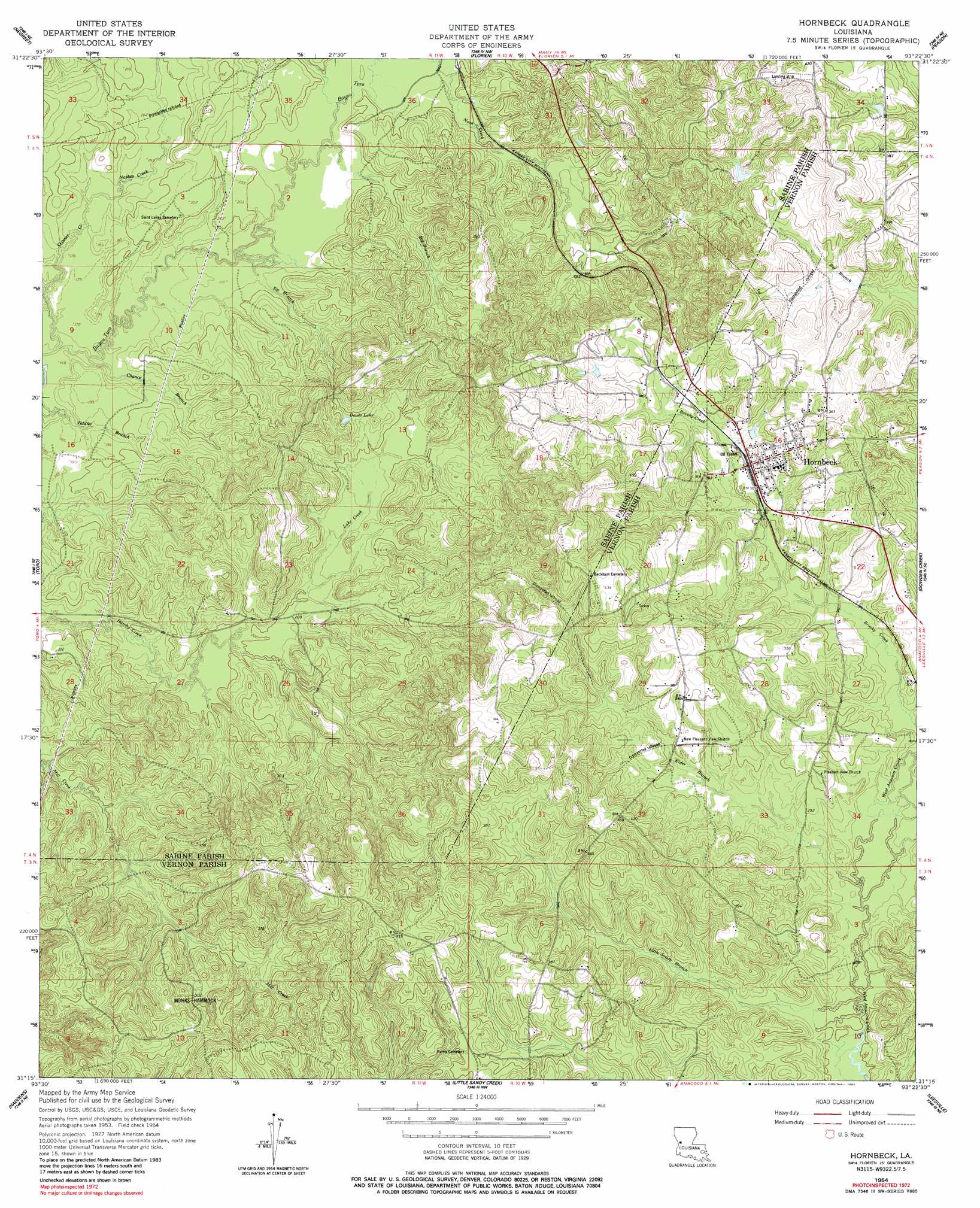
Hornbeck Topo Map Louisiana
To zoom in, hover over the map of Hornbeck
USGS Topo Quad 31093c4 - 1:24,000 scale
| Topo Map Name: | Hornbeck |
| USGS Topo Quad ID: | 31093c4 |
| Print Size: | ca. 21 1/4" wide x 27" high |
| Southeast Coordinates: | 31.25° N latitude / 93.375° W longitude |
| Map Center Coordinates: | 31.3125° N latitude / 93.4375° W longitude |
| U.S. State: | LA |
| Filename: | o31093c4.jpg |
| Download Map JPG Image: | Hornbeck topo map 1:24,000 scale |
| Map Type: | Topographic |
| Topo Series: | 7.5´ |
| Map Scale: | 1:24,000 |
| Source of Map Images: | United States Geological Survey (USGS) |
| Alternate Map Versions: |
Hornbeck LA 1954, updated 1958 Download PDF Buy paper map Hornbeck LA 1954, updated 1982 Download PDF Buy paper map Hornbeck LA 1994, updated 1996 Download PDF Buy paper map Hornbeck LA 2012 Download PDF Buy paper map Hornbeck LA 2015 Download PDF Buy paper map |
1:24,000 Topo Quads surrounding Hornbeck
Beech Bayou |
Loring |
Many |
Vowells Mill |
Bellwood |
Salter Creek |
Negreet |
Florien |
Peason |
Kisatchie |
Negreet Sw |
Toro |
Hornbeck |
Dowden Creek |
Kurthwood |
Fairmount |
Haddens |
Little Sandy Creek |
Leesville |
Slagle |
Wiergate |
Wiergate Se |
Burr Ferry |
Newllano |
Fort Polk |
> Back to 31093a1 at 1:100,000 scale
> Back to 31092a1 at 1:250,000 scale
> Back to U.S. Topo Maps home
Hornbeck topo map: Gazetteer
Hornbeck: Dams
Westbrook Pond Dam elevation 103m 337′Hornbeck: Lakes
Devils Lake elevation 87m 285′Hornbeck: Populated Places
Barham elevation 107m 351′Hornbeck elevation 99m 324′
Monks Hammock elevation 91m 298′
Hornbeck: Streams
Big Branch elevation 55m 180′Big Skinner Creek elevation 48m 157′
Chance Branch elevation 47m 154′
Elder Branch elevation 78m 255′
Lake Creek elevation 59m 193′
Little Sandy Branch elevation 76m 249′
Nashes Creek elevation 51m 167′
Sip Branch elevation 51m 167′
Skinner Creek elevation 47m 154′
Hornbeck digital topo map on disk
Buy this Hornbeck topo map showing relief, roads, GPS coordinates and other geographical features, as a high-resolution digital map file on DVD: