Peason Topo Map Louisiana
To zoom in, hover over the map of Peason
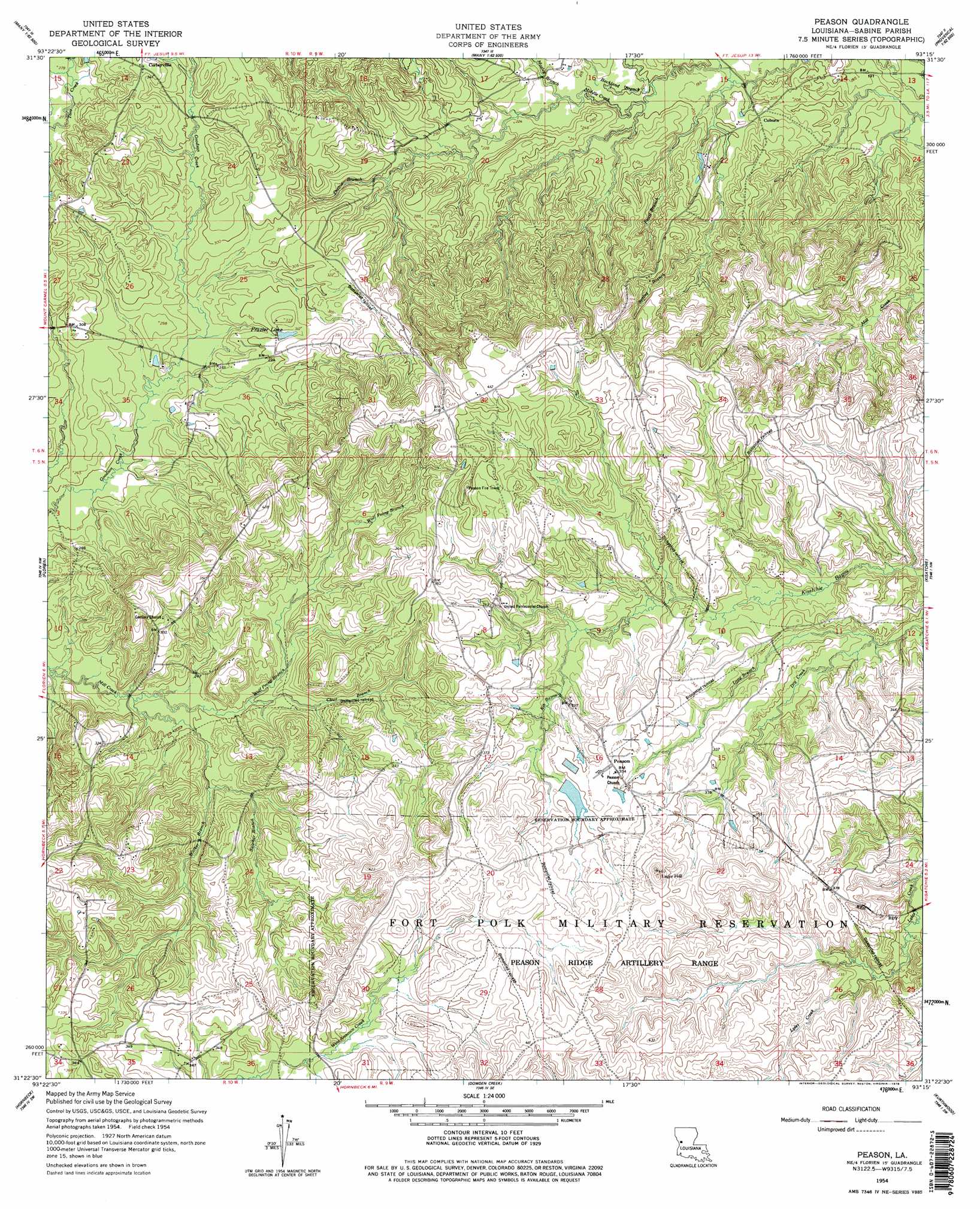
USGS Topo Quad 31093d3 - 1:24,000 scale
| Topo Map Name: | Peason |
| USGS Topo Quad ID: | 31093d3 |
| Print Size: | ca. 21 1/4" wide x 27" high |
| Southeast Coordinates: | 31.375° N latitude / 93.25° W longitude |
| Map Center Coordinates: | 31.4375° N latitude / 93.3125° W longitude |
| U.S. State: | LA |
| Filename: | o31093d3.jpg |
| Download Map JPG Image: | Peason topo map 1:24,000 scale |
| Map Type: | Topographic |
| Topo Series: | 7.5´ |
| Map Scale: | 1:24,000 |
| Source of Map Images: | United States Geological Survey (USGS) |
| Alternate Map Versions: |
Peason LA 1954, updated 1958 Download PDF Buy paper map Peason LA 1954, updated 1958 Download PDF Buy paper map Peason LA 1954, updated 1978 Download PDF Buy paper map Peason LA 1998, updated 2003 Download PDF Buy paper map Peason LA 2012 Download PDF Buy paper map Peason LA 2015 Download PDF Buy paper map |
1:24,000 Topo Quads surrounding Peason
Belmont |
Marthaville |
Robeline |
Provencal |
Flora |
Loring |
Many |
Vowells Mill |
Bellwood |
Natchitoches South |
Negreet |
Florien |
Peason |
Kisatchie |
Bayou Livrogne |
Toro |
Hornbeck |
Dowden Creek |
Kurthwood |
Simpson North |
Haddens |
Little Sandy Creek |
Leesville |
Slagle |
Simpson South |
> Back to 31093a1 at 1:100,000 scale
> Back to 31092a1 at 1:250,000 scale
> Back to U.S. Topo Maps home
Peason topo map: Gazetteer
Peason: Parks
Peason Ridge State Wildlife Management Area elevation 93m 305′Peason: Populated Places
Coburn elevation 66m 216′Corleyville elevation 105m 344′
Peason elevation 108m 354′
Peason: Reservoirs
Frazier Lake elevation 91m 298′Peason: Streams
Blackland Branch elevation 58m 190′Blue Lick Branch elevation 61m 200′
Clear Branch elevation 75m 246′
Faust Branch elevation 56m 183′
Kib Bayou elevation 93m 305′
Lone Star Branch elevation 52m 170′
Long Branch elevation 82m 269′
Mosley Branch elevation 63m 206′
Murphy Branch elevation 66m 216′
Prairie Branch elevation 72m 236′
Spring Branch elevation 55m 180′
Sulphur Branch elevation 77m 252′
Tynes Branch elevation 68m 223′
Walker Branch elevation 73m 239′
Wolf Prong Branch elevation 73m 239′
Peason: Summits
Eagle Hill elevation 115m 377′Peason digital topo map on disk
Buy this Peason topo map showing relief, roads, GPS coordinates and other geographical features, as a high-resolution digital map file on DVD: