Flora Topo Map Louisiana
To zoom in, hover over the map of Flora
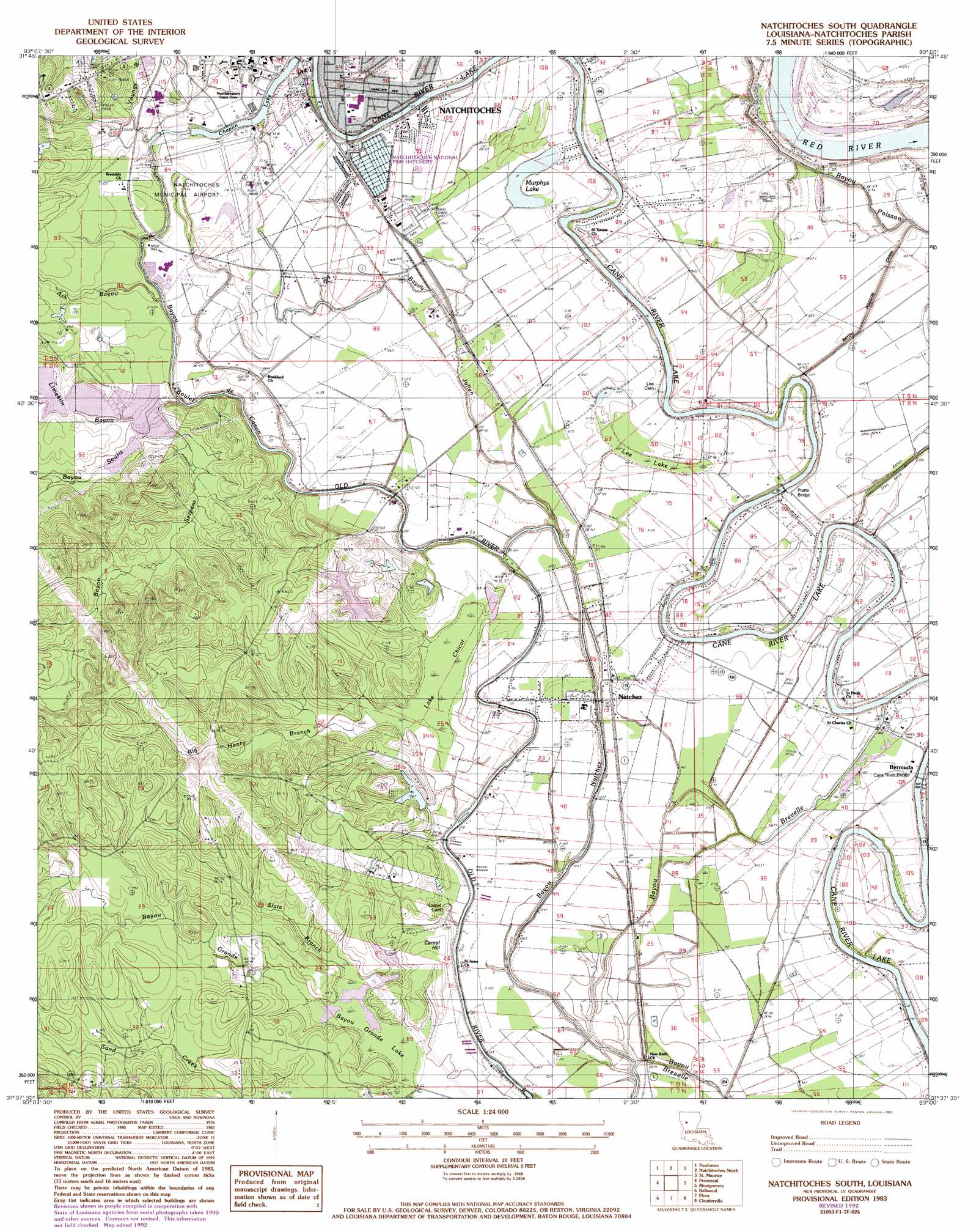
USGS Topo Quad 31093f1 - 1:24,000 scale
| Topo Map Name: | Flora |
| USGS Topo Quad ID: | 31093f1 |
| Print Size: | ca. 21 1/4" wide x 27" high |
| Southeast Coordinates: | 31.625° N latitude / 93° W longitude |
| Map Center Coordinates: | 31.6875° N latitude / 93.0625° W longitude |
| U.S. State: | LA |
| Filename: | o31093f1.jpg |
| Download Map JPG Image: | Flora topo map 1:24,000 scale |
| Map Type: | Topographic |
| Topo Series: | 7.5´ |
| Map Scale: | 1:24,000 |
| Source of Map Images: | United States Geological Survey (USGS) |
| Alternate Map Versions: |
Natchitoches South LA 1983, updated 1984 Download PDF Buy paper map Natchitoches South LA 1983, updated 1992 Download PDF Buy paper map Natchitoches South LA 2012 Download PDF Buy paper map Natchitoches South LA 2015 Download PDF Buy paper map |
1:24,000 Topo Quads surrounding Flora
Hanna |
Messick |
Campti |
Coup Point |
Calvin |
Allen |
Powhatan |
Natchitoches North |
Saint Maurice |
Coochie Brake |
Robeline |
Provencal |
Flora |
Montgomery |
Verda |
Vowells Mill |
Bellwood |
Natchitoches South |
Cloutierville |
Aloha |
Peason |
Kisatchie |
Bayou Livrogne |
Gorum |
Lena |
> Back to 31093e1 at 1:100,000 scale
> Back to 31092a1 at 1:250,000 scale
> Back to U.S. Topo Maps home
Flora topo map: Gazetteer
Flora: Airports
Natchitoches Regional Airport elevation 35m 114′Flora: Areas
Isle Brevelle elevation 30m 98′Natchitoches Island elevation 33m 108′
Flora: Bridges
Cane River Bridge elevation 30m 98′Pratts Bridge elevation 29m 95′
Flora: Canals
Bayou Poisson Canal elevation 32m 104′Flora: Guts
Bayou Natchez elevation 29m 95′Bayou Poisson elevation 32m 104′
Flora: Lakes
Cane River Lake elevation 34m 111′Chaplin Lake elevation 31m 101′
Murphys Lake elevation 32m 104′
Flora: Parks
Manning Memorial Park elevation 36m 118′Natchitoches National Fish Hatchery elevation 34m 111′
Turpin Stadium elevation 37m 121′
Flora: Populated Places
Bermuda elevation 34m 111′Natchez elevation 32m 104′
Point Place elevation 35m 114′
Vienna Bend elevation 34m 111′
Flora: Streams
Ash Bayou elevation 28m 91′Bayou Boulet De Canon elevation 33m 108′
Bayou Grande elevation 29m 95′
Bayou Julien elevation 30m 98′
Bayou Serpent elevation 29m 95′
Bayou Souris elevation 28m 91′
Big Henry Branch elevation 30m 98′
Limekiln Bayou elevation 29m 95′
Slate Branch elevation 48m 157′
Youngs Bayou elevation 32m 104′
Flora: Summits
Camel Hill elevation 40m 131′Flora: Swamps
Bayou Grande Lake elevation 29m 95′Bayou Grande Lake elevation 29m 95′
Lake Chicot elevation 30m 98′
Lee Lake elevation 33m 108′
Flora digital topo map on disk
Buy this Flora topo map showing relief, roads, GPS coordinates and other geographical features, as a high-resolution digital map file on DVD: